For Spring Break 2007 I thought I would try taking my family on a roadtrip of the Southwest. The main objective was to show them Boulder, Colorado, which I'd fallen in love with and was thinking of trying to find a way to live there for a couple years. I wanted to see if they liked it too and would be willing to do that. Or else maybe we could just spend a summer or two there in the near future. Spring isn't the ideal time to visit Colorado as we'd have to restrict our hiking to lower elevations, but it would be the ideal time to visit the Southwest, which otherwise would be much too hot. It seemed a good compromise. I'd bicycled to Las Vegas from the Bay Area, and we'd driven to Tucson during the last Thanksgiving break, but otherwise none of us had really seen the Southwest before. The plan was to drive first to Las Vegas, which I'd never really looked around (I bicycled straight to the airport and flew home) and which Kyoko was particularly interested in, and then continue through Utah visiting some national parks there and then onto Colorado. The return trip would be through Albuquerque and Tucson, so a nice big loop. I asked friends for recommendations of parks in Utah, and most said Zion was the best. So I definitely wanted to stop there, and perhaps also Arches (the second favorite) or Bryce Canyon, but it wasn't clear we could realistically see more than one this trip.
Sometime over the summer when surfing the web I ran across someone saying his two favorite hikes in the US were Half Dome and Angels Landing. As Half Dome is by far my favorite hike, I immediately looked up Angels Landing and was delighted to find it's in Zion! I'd never heard of it before but it's apparently very famous and popular. A couple good pages with information are here and here. It seemed similar to Half Dome in that it climbs up a major feature in the park, and the end has a sort of climbing/adventure aspect with chains added for safety. It seemed much easier than Half Dome, though, being only 5 miles roundtrip (versus 14) with around 1500 feet elevation gain (versus 4800 feet), and the last segment was only exposed, not really strenuous. Still although the last half mile was sure to be the highlight, I was a bit worried about taking Kyle (who recently turned 6) on it. Several pages mentioned it was not good to take young children on it, and although Kyle has some rock climbing experience in Joshua Tree (roped) and Malibu Creek (unroped), he has a tendency to not be very careful when he hikes. He does seem to concentrate enough when it counts. Also 5 miles could be a bit long for him depending on his mood. I figured we'd try it out and see how far up we could make it and turn back early if necessary.
Saturday we drove to Las Vegas, got caught in terrible traffic on the Strip, and finally parked somewhere and walked up the Strip. It wasn't very hot but still felt hot and Kyle got into a very bad mood and didn't want to do anything, even play games at Circus Circus when we finally arrived there. Kyoko thought Las Vegas was pretty interesting and especially loved the water show in front of the Bellagio, but although I liked some aspects of the Strip I must say overall I really disliked the place and have no desire to return. We couldn't find a decent hotel that would only let us stay one night there when we were planning the trip, and it's a good thing because after a few hours we just continued on to Saint George, Utah, which was a much more beautiful and pleasant place. It also had the advantage that we were only an hour or so from Zion. In fact driving to Zion the next morning we found plenty of hotels even closer that I would consider staying at in the future. But Saint George was a really nice place to stay as well.
I wanted to leave for Zion fairly early but Kyoko and Kyle like to sleep in late and we didn't leave until maybe 9am or so. We started the hike sometime before 10am. I think I recall seeing 9:53 on my watch but I may have misremembered. We finished around 1:53, meaning four hours later, which is the stated time for hike (on my map; the first website above says 5 hours!) but we went very slow and took some side trips, as I'll describe. Alone I'm sure I would have finished in under two hours.
It was still quite chilly when we started although I knew it would warm up soon. Kyoko and Kyle wanted to wear wool caps and gloves, but very soon into the hike, especially once we got into the sun, it got quite warm and I ended up carrying all their extra clothes in my backpack. I carried everything for everyone, including all liquids (a small bottle of Gatorade, one of Hawaiian Punch, and one liter of water, which were plenty for the three of us) and some snacks. We waited until we got into the sun and warmth to put on sunblock, which happened sometime in the middle of the switchbacks. We were in the sun for most of the hike so sunblock was critical.
The end of March is perhaps an ideal time to go, as not only was the weather great but it's just before the shuttle service starts in April, which means we could drive to the trailhead directly rather than worrying about taking a shuttle. We arrived at the Grotto only to find many cars already there--clearly this is a popular hike. Of course it was a Sunday, and we would share the trail with many other people--indeed we were still starting on the early side. Not quite the zoo that Half Dome becomes in the summer, but still very crowded. Of course it's popular for a reason!
The hike starts at around 4300 feet, and the summit according to the National Geographic map is at 5790; the stated elevation gain is 1488 feet. One gains this in 2.5 miles, but it's quite uneven. The hike starts off fairly gently, and then transitions into some steep and strenuous switchbacks. Then one reaches "Refridgerator Canyon", apparently about a mile long, which is mostly flat and a nice break. Then there are the steep but not difficult "Walter's Wiggles", another series of switchbacks, up to Scout Lookout at around 5000 feet. Finally there is the highlight of the hike, the final scramble to the summit, in which one gains the last 800 or so feet in one half mile. Even there there are some flat spots alternating with 2nd and easy 3rd class climbing.
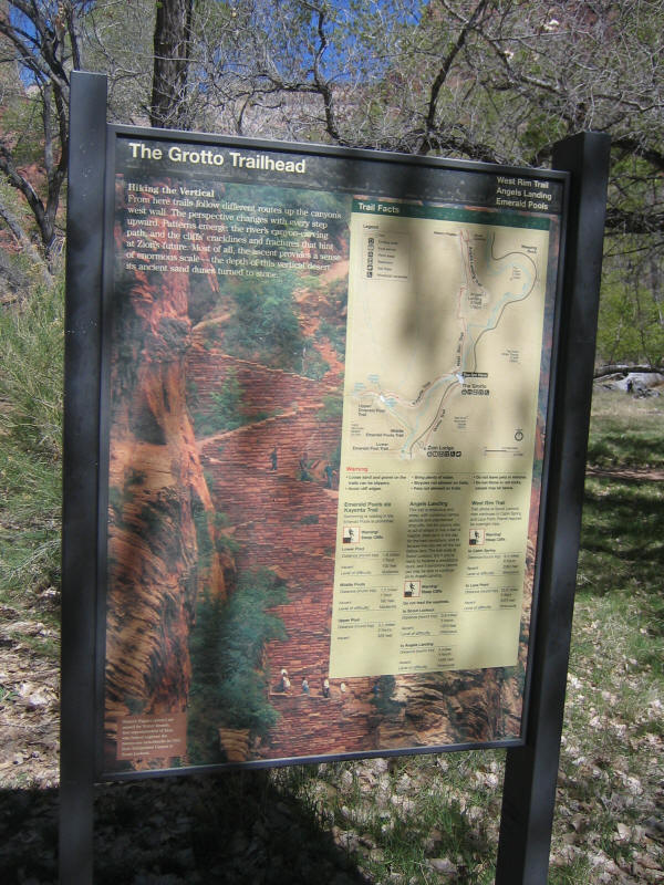
Now let's finally start with the pictures. The first three were actually the last three I took (in reverse order) at the end of the hike since the light was better then. Indeed most of the good pictures were taken on the way down and placed here out of order. Here's the sign at the trailhead.
Another sign just past it. I wasn't worried about myself this hike, but I was worried about Kyle. I'd recently read that a 29 year old woman had fallen to her death from this trail just last August.
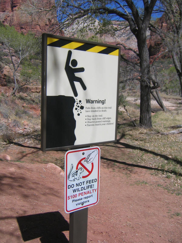
Here's the third sign. This was also worrisome and certainly if we ran into some ice we'd turn back. However I didn't even see a hint of ice the whole hike. Of course this trailhead leads to other trails and locations as well, so it's possible it was referring to something else, but more likely it was put up a while ago and no one bothered to take it down yet.

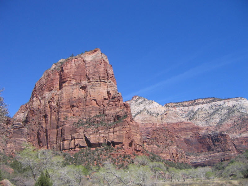
Angels Landing from near the start of the trail. This picture like the ones before it and after it were taken on the way down when the light was better. The trail goes up switchbacks near the far left, and the final trail to the top follows the visible ridge.
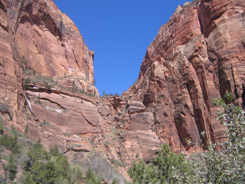
View to the left of the one above, showing the switchback section up the cliff. At full resolution (these pictures are all reduced 1/4) you can see some people on the trail.
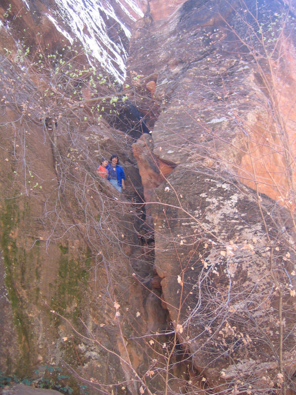
Kyle had no trouble on the switchbacks but Kyoko wore out very quickly. She recovered during the flat section through Refridgerator Canyon. During that section Kyle found a cool cave that you had to climb up a bit to get to, and it looked safe enough so I climbed up with him. He really loves to climb and explore, which is wonderful. The cave was small but had a secret passage that led to a narrow cliff fairly high up above the path. I didn't take any pictures at the time but there's one later in this report.
At some point, either the switchbacks or the flat section, we passed a father with two children around Kyle's age or maybe a little older, who were heading down. Kyle was running around with lots of energy, but these two kids looked completely exhausted. The girl told Kyle "you're going to be really tired!" and I wondered indeed how he'd feel at that point of the hike. It was good to see other kids doing it, in any case.
After the flat section you arrive at Walter's Wiggles, a series of very high-quality steep but short switchbacks. The picture below was taken from the bottom of them, I think, and again on the way down.
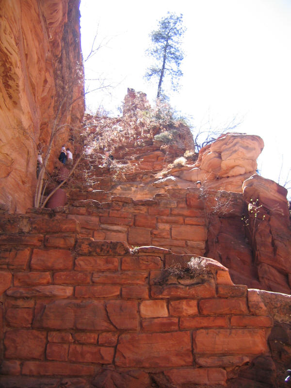
From here the pictures are in chronological order. We arrived at Scout Lookout, which I didn't take a picture of, and this is a common place for people to relax and also for many people to turn back, as this is the start of the final exposed half mile. Kyoko decided to wait here and not go on, but Kyle wanted to reach the top to see where the angels would land. Kyoko said many other people turned back or waited for others there, scared to go on, and I ran into one guy who said he couldn't go past a certain point because he got too scared. I'm a little surprised because I'm quite scared of heights and exposure yet I had no trouble on the trial. Perhaps years of rock climbing has numbed me to fear a bit, and also I was too worried about Kyle to worry about being scared myself. I will say, though, that the trail was a lot less scary and exposed than I feared. There were only a very few places that seemed at all dangerous, where you felt like you really had to be careful.
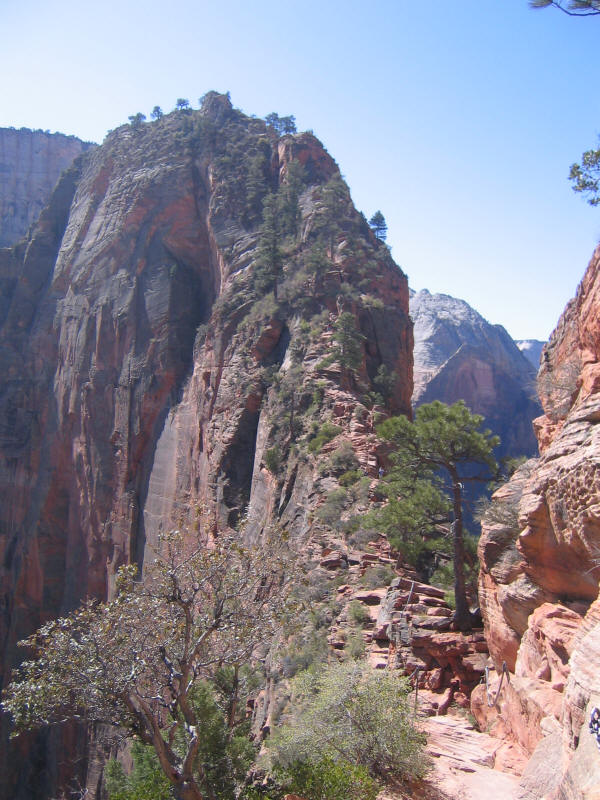
The picture below shows the start of the Angels Landing trail. The first of 22 chains can be seen at the bottom.
The chains certainly did help a lot to make one feel safer, although they usually were not necessary. I tried to get Kyle to hold onto them but he often held loosely or would let go. Sometimes they were too high for him to reach and I held his hand and then held the chain myself. He was careful when he needed to be, though, and I never felt he was in any danger. He's learned how to climb carefully both up and down and I was impressed by his ability. He impressed other people as well and many people complimented him. I think the word "trooper" was the most used, and many people asked how old he was or said they wished they had his energy. He seemed oblivious to all this during the hike, but toward the end told Kyoko that many people had complimented him, and was clearly proud of this. He wasn't the youngest person on the hike--we saw one couple on the final section guiding their son, who must have only been around 3 years old or even younger, down, but they were doing most of the work. There were quite a few other kids as well, but Kyle was certainly the youngest that day doing everything himself. People also commented on Kyle having no fear, which is true. Maybe he's just too young to have developed fear yet, at least this kind of fear. But I'll be worried if he doesn't start to develop some soon....
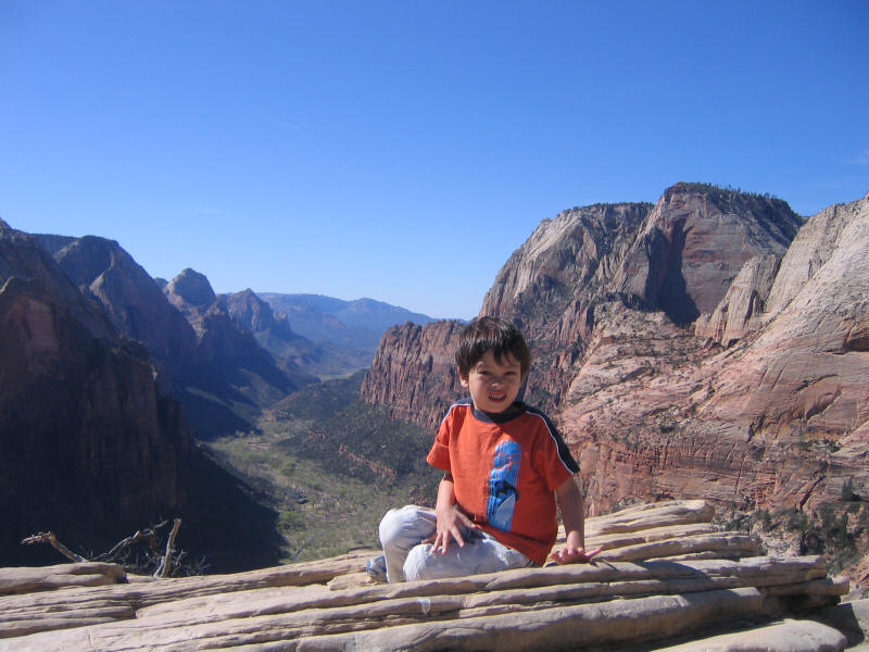
I didn't take any pictures as we made our way up, but we finally reached a flat wide section near the top and I took Kyle's picture here.
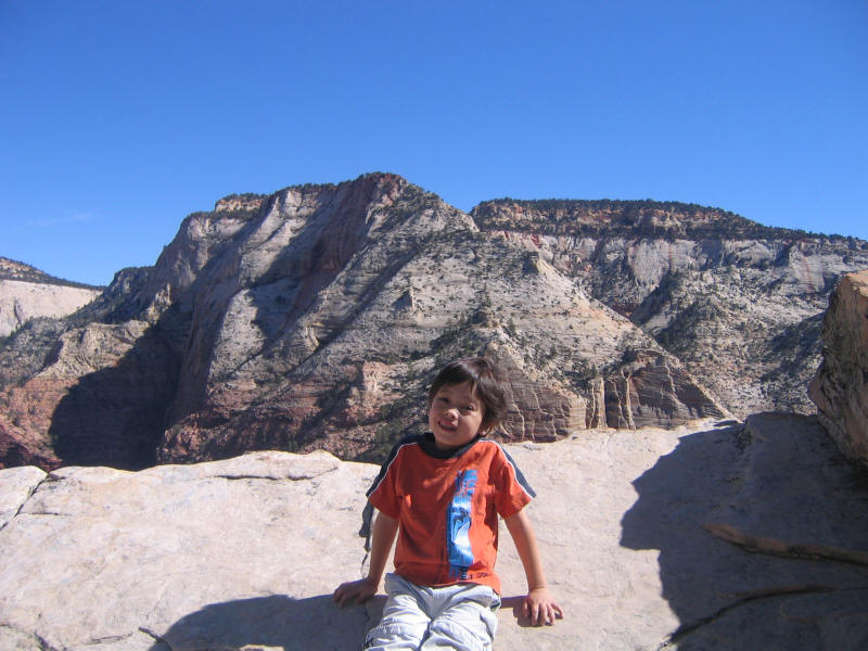
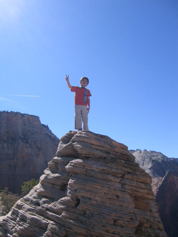
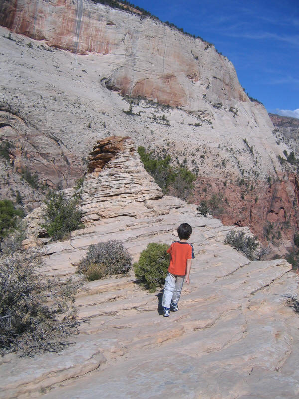
Soon after we reached the top and found a sort of "summit monument" there which I'm not sure is natural or artificial. Surprisingly Kyle started to climb it right away, without any thought. He went up a harder way, up the center of the front face in the picture, but then came down an easier way to the left. He seems to be a real peak-bagger, and this is so far his highest peak. I didn't want to get too far from him to take a picture so it's a little tough to understand the surroundings, but here is Kyle at the highest point.
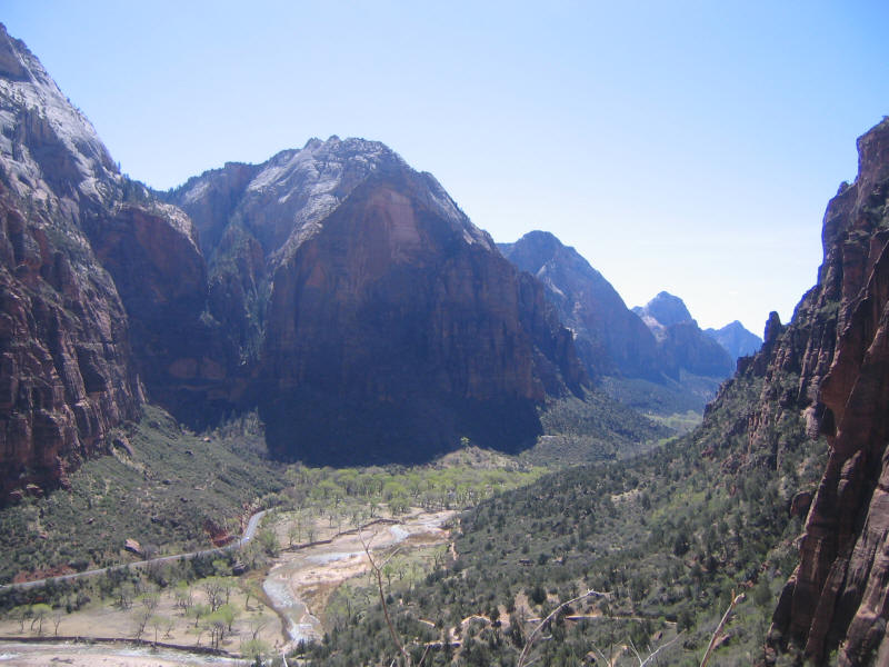
You can walk a bit behind this summit monument and things start sloping down rapidly and you get great views into Zion Canyon. Here is Kyle at this location.
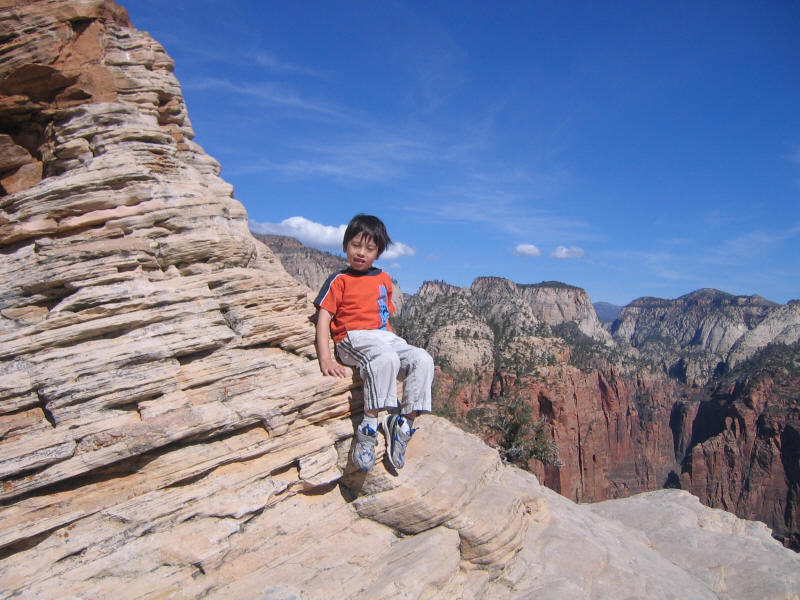
Here he is walking back toward the summit monument.
Kyle at the base of summit monument.
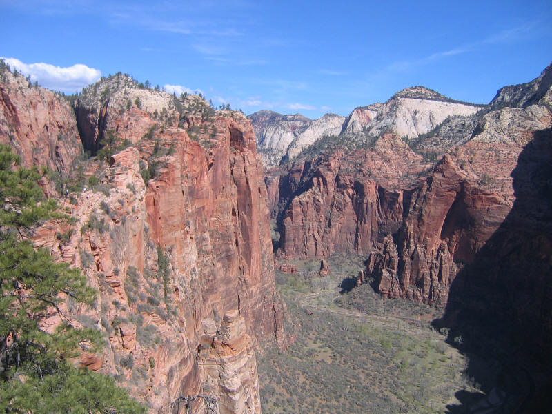
View into Zion Canyon toward the north. Just stunning.
I was worried Kyle might have used up all his energy on the way up, and get tired and in a bad mood on the way down. Fortunately this didn't happen. Kyle decided to play a game on the way down--to guess how many distinct chains there were. He guessed 10 and I guessed 30. Once we got past 10 he kept revising his guess upward, but only one or two at a time until I finally got him to guess "20 or 22". The latter turned out to be just on the mark, although it's possible we miscounted. We did count a pair of parallel chains (I think the 9th from the top) as one "double chain".
Finally we made it back to Kyoko. I didn't keep track of the time and she didn't have a watch, but it must have taken over 1.5 hours to go up and down the total of one mile. We stopped for a bit and drank and ate a little. Kyle wasn't very thirsty or hungry most of the hike, and seemed especially to drink too little--very similar to me on hikes! But I didn't notice any problems.
Kyle wanted to show Kyoko the cave and secret passage on the way down, since she had walked ahead of us when we explored the cave the first time. However somehow we passed right by it going down. We did however find a cave we somehow missed seeing on the way up. Who knows what these bones or of or why they are here. We guessed some person put them there, though.
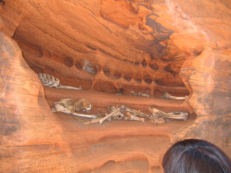
We got to the switchbacks and realized we'd passed the cave, and Kyle got very upset since he really wanted to show it to Kyoko. I figured it couldn't have been too far back, and so ran back and found it just beyond the cave with the bones. Kyle and Kyoko climbed up and in it, and although I unfortunately didn't take a picture of the cave itself here are Kyoko and Kyle on the ledge that the passage leads to.
I should mention too that I pointed out a rock wall also around Refridgerator Canyon, I think, and Kyle's response was that he wondered if he could climb up it. It was clearly too difficult and dangerous to do, but it's cool that he would immediately think of that.
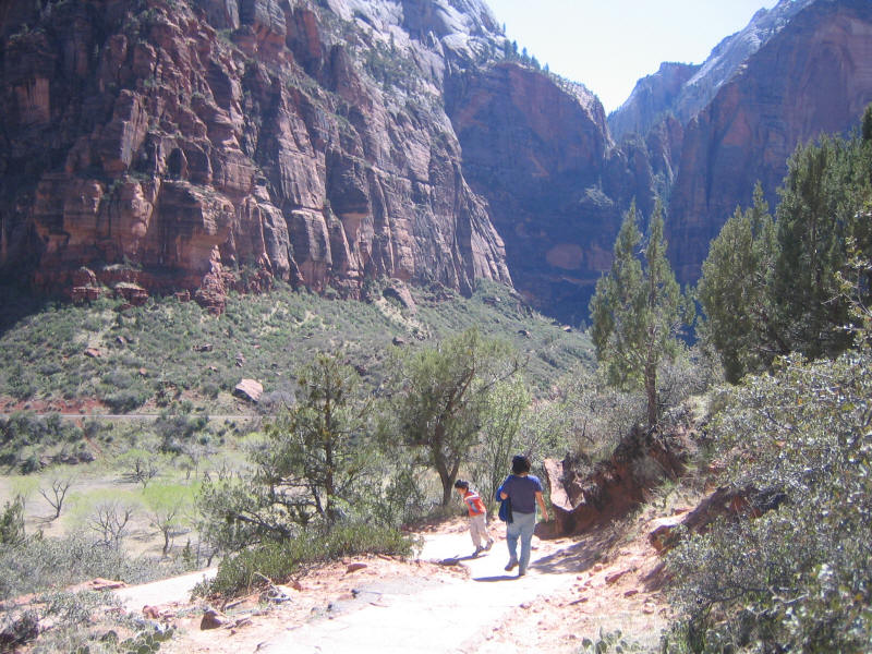
Here's a picture taken as we headed back down toward the Virgin River.
Kyle and Kyoko just before we went to the river. Kyoko wanted to take a look at it, and we found a side path that led to it. We tried without success to skip some rocks and Kyle played around in the river for a while. He still had plenty of energy left and was still in a great mood, so this hike was perhaps the perfect length for him. It's always nice to finish and still have some energy left.
He did fall asleep very soon after we started driving, as expected. Meanwhile Kyoko and I drove the 400 or so miles from the park to Grand Junction, Colorado, starting around 2pm and arriving at 8:30pm. I must say Utah, which I saw for the first time this trip, has to be overall the most beautiful state I've seen. The whole state seems like it could be a national park, and it's amazing how much visible from the highway is unspoiled.
In summary, a fantastic hike. No challenge for Half Dome which is still in a class by itself as my favorite, but certainly among the next tier which would include hikes like Fujisan and Whitney, and certainly the best short hike I've done. Zion is surprisingly not far from LA and would certainly make a great trip staying over a night or two. This was just a very brief visit, and I can't wait to go back and enjoy it more at leisure.