
Note that this report is very long. The most interesting section with most of the photos is Fujisan, so you might want to skip to there.
I worked in Japan in Summer 1990 and from 1991 to 1993, but for some reason I never thought of climbing Mt. Fuji when I lived there. I wasn't really into mountain climbing at the time, although I did climb some hill in Yokosuka with coworkers at NTT, and I recall when everyone called me over to the window to look out at Fujisan in the distance on one of the rare days of the year when one can see it. It was magnificent. Still I was more interested in pop culture then, and spent all my time on that. I do recall one other foreigner (I think from France) at NTT telling me she had climbed Fujisan one day. I don't recall her being that enthusiastic about it. All I remember is that she forgot to put on sunblock and got sunburned very badly.
I didn't really start to get interested in mountain climbing until the first time I climbed Half Dome in 1999. That major event was key to my starting rock climbing as well. By then I only visited Japan once a year or so, and always in Winter, which is a good time to visit Tokyo, but a bad time to climb Fujisan. I still didn't even think about climbing it, though. Finally in 2006 I was to visit Japan in August. I would normally never go at this time, when the weather is very hot and humid, but the first year memorial of Kyoko's mother's death was to be on August 20, and as I had missed the funeral last year I wanted to go to this. This summer I also happened to be particularly obsessed with mountain climbing for some reason. However I think it still took quite a while for me to realize this would be the perfect time to climb Fujisan. I searched the web and good information was hard to find, but a few sites were quite useful. A listing of them is at the end of the report. I found out indeed this was the ideal time to climb, but also the most busiest, in particular around obon when everyone is on vacation. However it seemed the main vacation week is from August 12 to 20. As our trip was August 15 to 24, I could try climbing right after the busiest time and hopefully avoid the worst crowds. I thought Mt. Whitney (which I have yet to do, but maybe this September) was an overcrowded climb, and it apparently gets something like 30,000 ascent attempts a year. Well Fujisan apparently gets over 200,000, and most of those come in a much smaller window of time than for Whitney.
I decided to try climbing on the 21st, since that would give a day to change to the 22nd in case of bad weather, and I might need an extra day to get back home if I somehow couldn't make the bus and/or train connections after the climb. A direct bus goes from Shinjuku to Kawaguchiko 5-goume (5th station), but the first bus I could take wouldn't arrive until 10:10am. The direct buses back only go until 4pm, and there was likely no way I could climb up and back that quickly. So I'd have to take a bus back to Kawaguchiko-eki (train station), and then catch a bus or train from there. I could reserve the ticket from Shinjuku, but I didn't want to have to reserve the bus back since I didn't know when I'd finish climbing. I certainly didn't want to have to rush back to get to some bus on time. It seemed if I could finish the hike by 7pm I should be fine, and I figured in the worst case I'd stay in some hotel overnight and come back the next day.
It wasn't clear just how long the hike would take.
For example
one page says 6 hours to get up and 3 to get down, while
another page says
The "average" climber on the popular Kawaguchiko
route might make it to the summit of Fuji in about 5 to 8 hours, or the
round-trip in 8 to 12 hours. A few will make it faster than that. Some will
take longer.
I wasn't sure what to make of this. Since the average
climber of Fujisan is apparently fairly old, I figured I would be faster, but it
wasn't clear how much. On the other hand since Fujisan is 3776 meters
(12,388 feet) high, and I've had altitude sickness problems before, especially
above 12,000 feet but even at times as low as 9000 feet, I figured that could
slow me down a lot. I would be coming from sea level (Kyoko says her house
is actually below sea level!) and climbing the same day, so there would be
no time to acclimatize. Yet this summer for some reason I'd seemed to have
no trouble at all with altitude, a strange change from before. I'd only
climbed as high as 11,500 feet, but previously I'd felt the effects of altitude
on such hikes whereas I didn't this year. I was curious then how I'd feel
on Fujisan.
I also wanted to walk around the crater, both since it would be interesting and because the true summit of Fujisan is on the opposite side of the crater from the high point of the Yoshida-guchi trail (which I'd be using--there are several other trails and trailheads as well). This would apparently add an hour or two to the time. My rough guess was that I could probably make it up in about 4 hours, around the crater in an hour, and then down in 3 hours (I'm slow at going downhill). So I figured about 8 hours total, which would get me back around 6pm. I could then take a bus down to the train station arriving 7-8pm, and take the bus back to Shinjuku from there, and then hopefully make it back to Asakusa before the last train to Higashimukou-jima. I had just barely made the last train on two previous nights (the 18th and 19th) and was hoping to not have to repeat that experience.
It would have helped get an idea of how long the hike would take if I could figure out the distance of the hike. However this information was surprisingly hard to come by. I did find one page noting that there was a sign saying that it was 6.3 km (3.9 miles) to the top, and estimating the descent route to be 6.8 to 7.0 km. Another site says 5.8 km up and 6.9 km down. I don't know why they give a different number than the one posted at the trailhead. Also looking at the map it looks like the descending trail is quite a bit longer than the ascending one. For now I'll say 6.3 km up and 7.0 km (4.3 miles) down, until I get better information. I was hoping to find such info in books and maps when I got to Japan, but I was surprised to find that the books and maps all list times rather than distances for all the routes! This information seemed almost worthless to me, although once I was able to compare my own times to the printed times it became more helpful. It seems most useful to know distance, elevation gain, and trail condition in order to figure out how fast you can go. Of course weather is another big factor, as is your own condition.
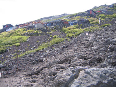
The trailhead is at 2305 meters (7562 feet), and tops out at about 3720 meters (12,205 feet), for an elevation gain of 1415 meters (4643 feet). This means an elevation gain of about 1190 feet/mile, which would make it likely the steepest hike I've ever done. What's more, from the 5th to 6th station must be about a mile (I don't have an accurate estimate), and that section is almost flat. The 6th station is at 2390 meters (7841 feet), and so one still has to climb 1330 meters (4363 feet) in roughly 2.9 miles, for a rate of 1504 feet/mile! I mention the steepness of other hikes I've done here, and probably the steepest overall has been Mt. Dana in Yosemite with a 3000 foot gain over 3 miles, so this would be quite a bit more. What was most surprising then is that Fujisan is considered a fairly "easy" hike that is done by everyone including people who don't normally hike and also small children. They do typically take two days to do it, stopping overnight in one of the huts, but I was still surprised it would be considered easy given that steepness. I felt the only explanation must be that the trail is in extremely good condition, and indeed for the most part it is. (Mt. Dana, on the other hand, is essentially mostly second class talus hopping, and so quite a bit harder.) Also the length is of course very short.
It may seem like I've devoted excessive time to talking about how long it might take to get up, but I was very worried about this especially as I had to make several train and bus connections to get home okay. What's more I was worried about my own condition. I hadn't done a serious hike since San Gorgonio on August 2, and had gotten sick just before coming to Japan so I had cycled very little as well. I fortunately mostly got over the cold by the time I did Fujisan, although I still had a persistent and annoying cough. I hadn't slept much in Japan due mostly to the heat and humidity--only 4 hours or less a night, so I was tired most of the time. And of course I was still worried about altitude sickness.
I did get in some walking in Tokyo, despite the heat and humidity. Partly this was inspired by learning that Meiji-doori, a major road that I knew went by Shinjuku, also happens to go very near Kyoko's parents' house in Sumida-ku! I thought it would be very cool to walk from their house to Shinjuku via that road, so I looked it up and saw it makes a big semicircle. I couldn't tell how long it would be, but I figured if it was too long I could just take the train back from any point--one great thing about walking in Tokyo. However I decided to take a different route to Shinjuku first (August 17), along Yasukuni-doori, another major road that I'd probably walked the length of before. It's a more straight path, probably around 10 miles, and passes near Akihabara and goes through Ochanomizu and Jimbouchou, places I wanted to visit anyway. So I walked along there and unfortunately the heat and humidity were so bad that it wasn't a lot of fun. It rained off and on as well, and at first I wished for the rain since I thought it might cool things down a bit, but it didn't help at all and only increased the humidity. Fortunately I had plenty of opportunities to go into stores and cool down a bit. I stopped in a couple sporting goods stores in Ochanomizu to look at hiking stuff, and was surprised to find the stores not nearly as good as REI. What's more I didn't recognize any of the backpack brands, for example, surprisingly. My friend Okamoto-san told me Arc'Teryx, my favorite brand which he also likes, used to be sold there but not recently. I did see a couple people with Arc'Teryx Bora backpacks later.
I ended up walking only to Yotsuya 3-chome, a little short of Shinjuku since I didn't want to double back, where I met my former boss Oda-san and some other colleagues for dinner. I decided the walk was unpleasant enough that I didn't try Meiji-doori--I'll save it for some trip not during summer. The walk had an unfortunate consequence: I got about four blisters on my toes, two on each foot. I never get blisters walking around LA--I'm sure it was the humidity that did it. So now I had something else to worry about! However my new hiking shoes, now broken in, not only didn't give me any of the heel trouble I'd had on San Gorgonio, but they were kind to my toes as well. I brought moleskin just in case but didn't put anything on, hoping it would all work out, and it did. My feet were fine the whole hike and the blisters didn't even pop.
I brought standard hiking equipment to Japan, including a headlamp, fleece, Gore-Tex rain jacket, lightweight capilene underwear, gloves and a wool cap (as the summit can get cold and windy). Okamoto-san had warned me that the sand/ash of the trail can get into your shoes and socks, so I also bought some desert gaiters at REI and brought them. However on the ascending trail I found no use for them and didn't wear them. It was the descending trail that had all the sand. Even then I didn't wear them and couldn't feel any sand getting in my shoes, but my liner socks were a little blackened when I got back and looked at them. Maybe next time I'll try the gaiters and see if they make any difference. I almost didn't bring the headlamp with me but decided to at the last moment. I don't know why I didn't think about it more clearly. With no Daylight Savings Time in Japan it gets dark early--sunset was 6:23pm. I got back at 5:30 and it was still light, but could easily have arrived later. One thing I forgot to bring to Japan was my non-cotton "technical" tee shirt. Fortunately this was about the least important thing to have. I was worried I'd sweat on the hot lower section and then the sweat would get very cold as I got higher, but I figured I could change to the long underwear top if necessary. It was indeed warm on the lower part of the climb and my shirt got wet from sweat, but it wasn't enough to bother me when I got higher. I never needed the rain jacket as the weather was very nice, fortunately, but it did get cold higher up and I wore the fleece from about the "hon" 8th station to the top, and then took it off again when I got back down around the "hon" 8th station.
Before I went to Japan I asked Takehiro Okamoto, whom I knew from when I worked at Matsushita, if he would like to climb Fujisan with me. I knew Okamoto-san has a lot of experience mountain climbing in Japan, and I'd also rock climbed with him once at Yugawara Makuiwa (湯河原幕岩) in Kanagawa-ken, the first and so far only time I've rock climbed outdoors in Japan (October 21, 2000). I'd also taken him and his wife Kazumi to Yosemite and had hiked halfway up Half Dome with them. Okamoto-san had already climbed Fujisan before, and for various reasons did not want to go this time. However he did propose to take me and my family to Kamikouchi (上高地), an area in a valley in the Northern Japanese Alps with stunning views of the mountains there. However since we were due to meet on the 16th, the day after we got in, we decided we'd be too tired to that. Instead we met at Kinokuniya, the huge bookstore in Shinjuku (at the original branch), and had lunch at my favorite Keika Ramen. At Kinokuniya I asked Okamoto-san to recommend some books and maps of mountains to me. For maps he recommended the Shoubunsha (昭文社) series as the best; I was already familiar with their maps of Tokyo, which I also consider the best available. I got the map for Fujisan and also Hotakadake (穂高岳), the third highest mountain in Japan and the one next to Kamikouchi. Both Okamoto-san and I picked up a recent large-format book of the Japan Alps as well, also published by Shobunsha, and later I would come back to buy a two-volume set they published titled Nihon Hyaku Meizan o Noboru (日本百名山を登る), Climbing the 100 Famous Mountains of Japan. I love to learn new things and since I knew nothing about mountains in Japan this is a whole new area to explore, even more interesting since I can read about it in Japanese and learn a lot of new vocabulary (my mountain-related Japanese vocabulary was just about nil, but it increased substantially this visit).
One thing I learned from looking at these books is just how useful public transportation is when climbing mountains. In the US it's pretty much impossible to get to trailheads without driving, but in Japan you can always take some combination of trains and buses. The disadvantage is that they don't necessarily get there that often, so you are stuck with their schedule to get there and might have to wait quite a while to get back, including at each connection. The advantage, though, which I hadn't thought about before, is that you can climb up one route and come back an entirely different one! When using cars that requires a lengthy shuttle, but with buses there's no extra effort at all! I could for example have climbed up Fujisan from Kawaguchiko but then descended the Fujinomiya trail, although the latter would be a longer trip back to Tokyo. Still it's nice to not have to double back. Since this was my first time and the descent trail is mostly different from the ascent one I wanted to stick to one trailhead, but I was tempted to go down the other way as I'll explain below. Certainly that's something to try in the future. It's very cool that one can be so flexible.
The bus would leave from a station at the west side of the train station, so Okamoto-san helped me buy an advance ticket there before we headed to Akihabara. This way I knew where to go to get on as well. I also picked up a nice pamphlet with information and the bus schedule (although not the shuttle bus between the 5th station and the Kawaguchiko train station for some reason). Strangely this pamphlet was available in English, Chinese and Korean, but not in Japanese!
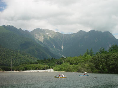
I had Saturday free and asked Okamoto-san if he and Kazumi-san would be willing to go to Kamikouchi with me that day. Kazumi-san wasn't really interested but Okamoto-san, who hadn't gone for several years, was willing to go again. He planned out the trip and decided we would take an express train from Shinjuku to Matsumoto in the morning, followed by a short train to a place called Shin-shimashima and then a bus to Kamikouchi. Then in the afternoon we'd take a bus from Kamikouchi straight back to Shinjuku--a little more time, but much less expensive. After a pleasant train and bus ride we got off a little early at Taishou-ike (大正池), which already had excellent views of Hotakadake as well as the volcano Yaketdake (焼岳), another of the 100 famous mountains of Japan. It was a little cloudy in the late morning, as we had feared, but fortunately the clouds were high enough to only obscure the very top parts of the mountains, and later on we'd be able to see even them. The weather was perfect--temperature just right, and low humidity, so a welcome change from Tokyo. Below is the view of Hotakadake from across Taishou-ike.
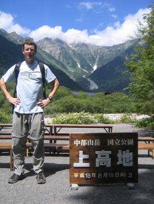
We had a pleasant walk to Kamikouchi where I got my picture taken at what seems to be the standard tourist location. The place was indeed full of tourists, although as we got away from the main centers we could experience some kind of solitude. I was surprised to read that Hotakadake is the most popular mountain in Japan, especially since I'd never heard of it and Fujisan is so famous. Okamoto-san and another friend confirmed this, saying it was considered more beautiful closeup than Fujisan is--Fujisan is more of a mountain to be admired from a distance than to be climbed. Still I find it hard to believe as many people climb Hotakadake as climb Fujisan.
At Kamikouchi Okamoto-san tried to buy return bus tickets to Shinjuku, but found they were sold out! So we had to buy a bus ticket just to Matsumoto and take the train back to Shinjuku from there. Much more expensive, but an advantage was that we could leave a little later (at 4:40pm rather than 4pm). I had noticed also that I'd lost my sunglasses. I wasn't sure where but I expected it was on the bus. Thankfully Okamoto-san was with me and knew where to go to ask about them, and could describe in detail which bus we took and where we sat, things I'd already forgotten. I didn't really need the sunglasses for this day since it was mostly overcast, but would need them for Fujisan and was worried about where I'd find something to replace them in Japan. So that put a bit of a damper on the day.
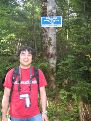
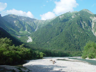
We got some lunch at a cafeteria, Okamoto-san ordering some ramen which he said was so-so, and I ordering katsu curry which was surprisingly good. We then headed toward Myoujin (明神) along the river, crossed there, and headed back on the other side. It was a very nice hike with beautiful scenery much of the time, and in the woods at other times--since I'm used to hiking near LA that was a rare treat. On the way back we intersected a trail that goes right up Hotakadake. I knew we didn't have time to go up much, but the trail so far had been flat and I wanted to experience a little bit of the feeling of climbing a mountain, so we decided to go up until about 3:45pm, which should give us enough time to get to our bus. The climb was not too steep at the bottom (apparently it gets much more steep high up) but it was very enjoyable to be actually climbing. After a little while we could feel a very cool breeze which apparently comes from some kind of wind holes in the mountain--I still don't understand this, but it felt great. We thought we might be able to get above the treeline and get some good views, but once 3:45 came we still seemed to be a little while away, so we turned back. Below is a picture of Okamoto-san at the highest point we got to. There's a sign there saying we are 90 minutes away from the Dakezawa Hut (岳沢ヒュッテ), which a lower sign said was damaged by snow this year and closed. The signs seem to countdown to the hut (this one was 8), and the previous one said we were 120 minutes away but we'd only taken 10 minutes between signs so we were going about double speed. Indeed comparing our speeds to the map it seemed we were consistently going about twice as fast as they indicated, and I hoped I could hike a similar pace on Fujisan. Okamoto-san later learned that the treeline is at around sign 6. We did discover on the way down that there was a break in the trees with an excellent view of a mountain with the interesting name "Mount 600" (六百山). We both couldn't figure out how we'd missed that on the way up.
On the way down we took some more pictures of Hotakadake, since the clouds had cleared up a bit. I'd love to climb this mountain some day....
We got back down a little early, and so went back to the bus station to ask about my sunglasses. I didn't have any hope they'd be found, and so was extremely surprised and delighted that they had found them! That cheered me up a lot. However the day was not over. We made it back to Matusumoto on the bus, although there was traffic congestion near the end so maybe it would have been better to take the bus to Shin-shimashima and then the train from there as we had done the other direction. We ended up having to wait about 1.5 hours for the next train to Shinjuku. Since we had so much time we walked around Matsumoto a bit and looked for a place to eat. Okamoto-san seemed more interested in spaghetti or some other non-Japanese food, whereas I only wanted to eat Japanese food during my short stay there. I'd enjoyed the katsu curry so much from lunch that I wanted to eat curry again, so we went to a curry restaurant which had a great ambiance inside. Unfortunately the food took forever to arrive, so although it was delicious (I especially liked the raw egg in my curry) I was able to eat less than half (Okamoto-san had more wisely chosen the half-size--the full size was so big I was full anyway after eating half of it).
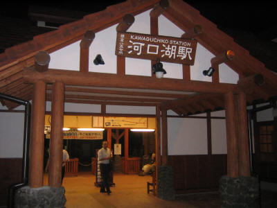
It appeared we would make it back in plenty of time for me to catch connecting trains back to Sumida-ku, but somewhere midway back the train stopped and made an announcement that due to some incident (which turned out to be someone killing himself by jumping in front of a train) that the trains were all stopped due to some kind of safety checks--I'm not sure what they had to do, but they ended up halting all the trains around Tokyo, not just the Chuo Line that we were on. So JR was a huge mess. After a half hour or more of waiting we finally got going, and since we were the super-express we passed train after train stopped at intermediate stations as we inched along toward Shinjuku. I was very worried now that I was not going to make it back in time for the last train out of Asakusa, which I knew left at 12:29am since I had just barely made the same train two nights before (after staying out too late drinking with friends in Tsunashima, Yokohoma, where I used to work). I had already been worried that getting home from Fujisan was going to be far more of an adventure than climbing it, but I never thought getting home from Kamikouchi would be an adventure as well! Okamoto-san got off at Kichijoji, so he could catch a more direct train back to Yokohama where he lives, and I eventually made it to Shinjuku. I thought my troubles were over, but soon learned the Chuo line stops running that late, and the alternative Sobu line doesn't go to Kanda. I'd figured if I could get to Kanda I could walk back from there although I didn't remember the exact route. In any case the Sobu line was also not running, nor was the Yamanote line, due to the same problem. I waited for a bit and then decided to give up and try something other than JR.
Looking at a station map I found the Marunouchi subway line goes to Shinjuku, something I'd forgotten about since their station is a bit inconvenient so I don't normally use it. I just barely caught a train (the next one was 14 minutes later), transferred at Akasaka-mitsuke for the Ginza line, and made it back to Asakusa literally just a couple minutes before the last train out left. Had I missed that train in Shinjuku I wouldn't have made it. It had ended up taking 8 hours to get back home.
Sunday was a rest day of sorts as the 20th was the one-year memorial of Kyoko's mother's death. There was a short ceremony at the Shinto Shrine at which her ashes are buried, followed by a lunch. Most people are buried using Buddhist rites but Kyoko's mother wanted Shinto instead, and that seems to have been an excellent choice. The religion is apparently a lot more casual and friendly than Buddhism. The ceremony was very interesting and pleasant, and the relatives who visited were very nice people, so despite the occasion it was a good day. Also I had visited Kamikouchi the previous day and would climb Fujisan the next day, and the symmetry of that pleased me.
(Note that the pictures below, as for those above, have been greatly reduced in size since there are so many of them. I apologize for the difficulty in seeing detail.)
Sunday afternoon I went to the nearby 7-11 with Kyoko to buy snacks for the hike. I've done enough hikes by now to realize I don't like to eat much during them. Although it seems I should eat a lot since I'm using up a lot of energy, for some reason I just feel ill if I eat too much (as happened on the recent rock climb at Tahquitz) and end up slowing down. Even for week-long bike rides I find I can't eat too much. I haven't quite figured this out, but at least so far just eating some snacks a little at a time as I go up seems to work well. I bought what's shown below, although I ended up trading the big bag of senbei/peanuts for two very small bags as I figured it was dumb to have to worry about the contents of a half-eaten bag getting loose. The thing on the right is cheese-flavored bread which Kyoko had found this trip and which was quite delicious. I got two packages of my favorite Japanese candy Meiji Gummi, and intended to eat the grape flavor on the summit, but the summit turned out to be a bit too cold and unpleasant so I ended up eating most of it on the bus back. I typically stopped at the huts, rested a bit, and ate a little of whatever I felt like at the time. On the descent I didn't eat at all, save for the first half of the grape gummi.
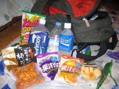
I brought two liters of liquids, 1.5 being sports drinks and 0.5 being water. I figured this was probably enough and I could buy more easily along the trail, even if it was expensive. I ended up not buying any more during the hike. I drank 1.5 liters or maybe a little more going up and around the crater, and then finished off the rest on the descent and wished I had a little more, but I was fine. I bought another 0.5 liter bottle of Aquarius at the 5th station for the ride home, but ended up drinking very little of it. In retrospect I should have just bought all the food in Shinjuku or even the 5th station instead of hauling it there, and carried just 0.5 liters of drink and bought more as I needed it on the way up. Although the prices, as I had heard, were expensive and increased as you go up, it would have been worth it to be able to carry less. I could have carried no snacks as well but those weren't very heavy.
I made it to the bus station at around 7:15, a half hour before we were to leave. I'd noticed my ticket was not for a window seat, so I wanted to see if I could change it. However when I was waiting in line I noticed on the electronic sign that there were two buses going and both were full! So I didn't even bother asking. I took a walk around the nearby neighborhood, looking at the skyscrapers of Shinjuku Nishiguchi. It was kind of cool to be looking at the tallest building in Japan on the same day I was climbing the highest mountain.
I made it back and found where the bus was to leave. However only the 2nd bus was there and I was to go on the 1st bus. There was another foreigner waiting, looking a bit confused as well, and although I normally avoid other foreigners when in Japan and I decided to say hello to him. It turned out he was also on the first bus, which eventually arrived. Our seats were close together and a Japanese guy offered to swap seats with me so I sat next to the other American, whose name was Bob Kimmel. I learned that he was a professor just starting this fall at Ohio State after leaving Princeton, and specializing in mathematical finance. So we had a very enjoyable talk on the ride and the next 2.5 hours flew by. We talked about math, school, and also climbing. He was here for a conference and had never been to Japan before, but he'd been to China and Singapore and so forth often. He'd also climbed Mt. Whitney in California, something I still have yet to do. He had decided to climb Mt. Fuji on this trip but hadn't planned very well, so he'd just showed up at the bus station and tried buying a ticket that day. Even though the sign said sold out they'd sold him a ticket for our bus, and indeed two seats were still empty so that was a little strange. However they wouldn't accept a credit card so he was worried he didn't have enough money. He had enough to buy a little food and get back, but not much more. I was worried if something went wrong and he needed to stay in a hotel overnight what he would do--but hopefully he could find a hotel that accepts credit cards. He also hadn't brought a backpack, so he had his stuff in a duffel bag that he'd store in a coin locker at the 5th station and then climb with his rain jacket and so forth tied around his waist. This all sounded a little worrisome but I figured as he had mountain experience before he'd be fine.
As we got close we could see that it was unfortunately cloudy, as expected. Normally it's only clear in the early morning, which is one reason people try to summit at sunrise. However we could see a bit of the outline of the Fujisan through the clouds. Even that little bit was extremely impressive. One thing photographs cannot convey is just how enormous Fujisan is and how completely it dominates its surroundings. Just the tiny bit I could see conveyed that feeling, and I hope in the future to see it in better weather. Aside from the cloudiness, though, the weather was as good as one could hope for. A little on the warm side lower down, although it would get colder higher up. The air felt great. No rain at all. I couldn't have asked for better weather.
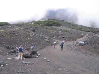
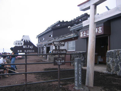
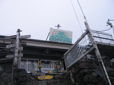
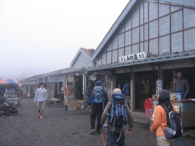
Finally we arrived at Kawaguchiko-guchi 5-goume (河口湖口五合目), the 5th station, and it was every bit the tourist zoo I imagined, if not more so. I should explain that Fujisan, and also apparently a few other mountains in Japan (probably also isolated volcanoes with reasonably well-defined bases) are divided into ten "stations", the tenth being the summit. It's not exactly clear from the map I have just where the "start" is, though--only the first station of trails is marked. Anyway we were cheating a bit by taking the bus "halfway" up, to the 5th station at 2305 meters (7562 feet), but that's where most people start from and I wanted to minimize distance so I could do this as a day trip. (Note incidentally that the 5th stations of other trails are at completely different heights.) The bus also stops at the 3rd station for those who want a slightly longer hike (less than an hour extra each way at my pace, probably).
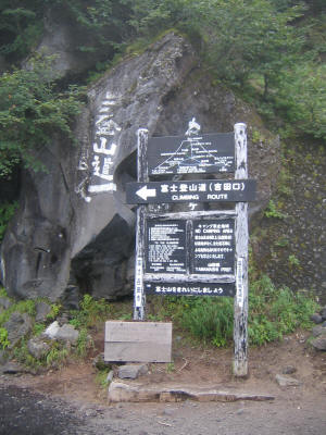
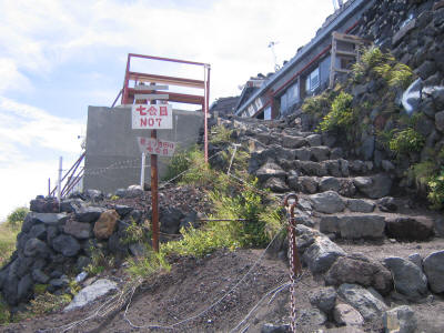
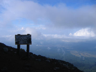
Bob went off to find a coin locker, while I stopped at a restroom and then wanted to start as soon as possible. I didn't even want to bother finding where to buy the return bus tickets, figuring it would take me the same amount of time or less to do that after the climb. However I was surprised to find it very difficult to figure out just where the trailhead was! For such a popular climb I couldn't believe it wasn't better marked. There is the sign below for people to take their picture in front of, which gives the current elevation and says it is 6.3 km to the top. However this sign is not near the trailhead!

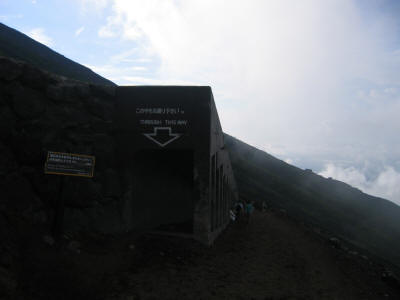
I guess what people normally do is just follow everyone else (and more specifically most Japanese seemed to be climbing as part of tour groups with their own buses and guides), but this was an unusual time to begin a climb. Indeed most people seemed to be returning from their climb, having stayed up to witness the sunrise from the summit. So I figured if I could find where they were coming from I would find the trailhead. However there were so many people milling around at the 5th station and going to and from every corner it was hard even to determine that. Eventually I figured out a likely candidate for the trailhead, shown below. Believe me if you can't read Japanese that the writing on it gives no indication this is the way to go, or at least it didn't to me. So I asked a couple women who had just come from that direction. The first either didn't speak Japanese or didn't believe what I was speaking was Japanese, but the second one said indeed that was the way to go. I wasn't the only one who had trouble. When I came down a Japanese group asked me (in bad English) which way to go at one confusing fork in the trail.
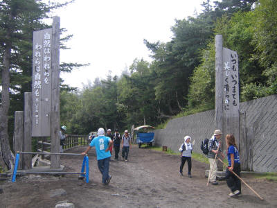
I still was a little uncertain this was the start, but I recorded my start time, 10:14am, on a piece of paper (the detailed times are at the end of this report) and started off. Although I was passing a fair number of people coming the other way, and they looked exhausted so that was a sign I was going the right way, my uneasiness was heightened by the fact that the trail actually goes downhill slightly at the start! I was worried I was heading for the 4th station, and by the time I found out I'd have lost a lot of valuable time. But then I figured almost no one starts lower than the 5th station, so I was probably okay. After a little while I ran into the sign below, which indicated I was probably going the right way. Notice that the English part is so scratched out that it is completely unreadable.
Finally a little past that I found a sign that showed I was definitely on the right route. The trail started ascending, and I could really enjoy the climb now without worrying I was going the wrong way. Indeed although I brought a map (but no compass, which would have been useful at the beginning) I didn't need it as the trail was quite well marked save for the very beginning.
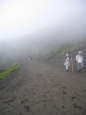
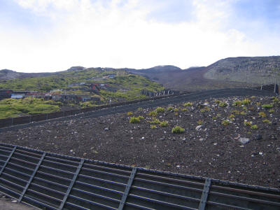
As I mentioned earlier the trail is fairly flat from the 5th to the 6th station. It's very wide as well and pleasant to walk along. We were in the middle of a cloud at this altitude so I couldn't see much, but it was still very nice as the picture below shows.
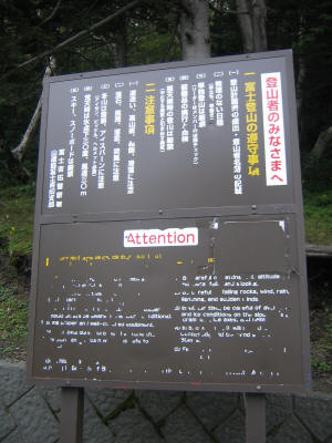
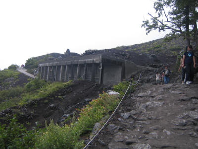
After less than 20 minutes I reached the 6th station. Actually the picture below is a structure right below the 6th station. It's hard to see but there's a loudspeaker mounted on this structure (which is for safety from rockfall), and there's another one at the 6th station itself. From these speakers is looped a recorded message in Japanese followed by English warning about the dangers of the hike, saying things like don't go up just wearing a tee shirt because it gets very cold on top, and make sure you have raingear. They also warned about taking the right descending trail, since that gets confusing and you could end up far from the trailhead you intended to exit from. This audio message is a good idea, actually, as most people probably don't read the signs, but it was somewhat disconcerting to hear it in the middle of a hike supposedly through nature. I was to learn though that Fujisan is very different from any other mountain climb I've done.
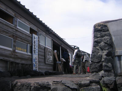
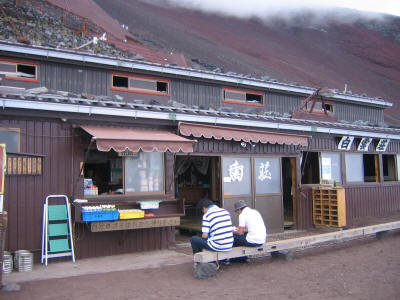
I soon arrived at the 6th station and the first of the huts. I stopped here for 9 minutes, my usual stopping time it would turn out (maybe not a good idea as 9 is a bad number in Japan, and indeed there were no huts or markers at the 9th station), and ate some food. I probably also put on sunblock at this point. This was I guess the second time I'd done a hike that involved huts (the first being the High Sierra Camp loop, although that had a much different feeling to it), but such huts are very common in Japan it seems as well as Europe apparently. I hadn't thought about staying overnight in such a hut, but when I saw them in person they looked very pleasant and clean. You sleep on futons on tatami, and it seemed it would be a nice place to spend the night if it weren't crowded with other people (I've heard they put two per futon when necessary).
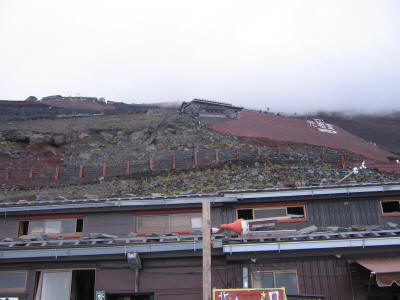
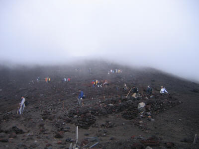
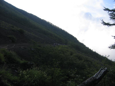
One great thing about the Yoshida-guchi (吉田口) trail, as it is called from this point (its own trailhead goes back a different direction) to the top, is that it is fairly straight, so you can look up and see the entire trail snaking above you. I love it when I can see the trail for a long way. What's more you can see all the huts along the trail, and I was surprised how many there were. I'd thought there was just one hut per station, but it turns out there can be up to 4 or so, and there were also some extra stations I didn't realize existed. The picture below was taken from just beyond the 6th station, I think, and shows the first hut of the 7th station in a break in the clouds. The trail was still mostly dirt at this point and not too steep, with a lot of wide switchbacks leading up.
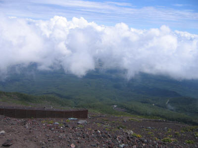
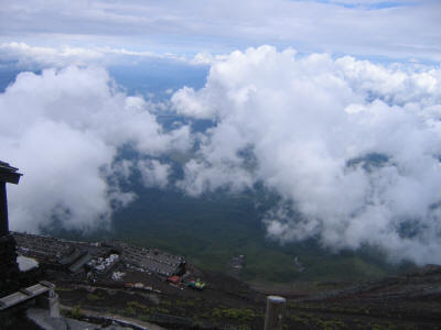
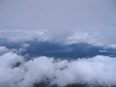
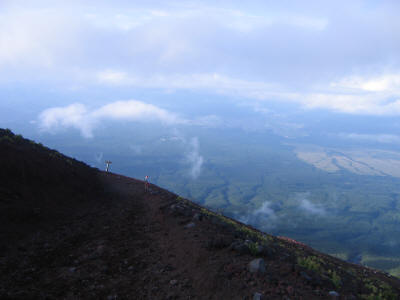
Looking down I could start to see some scenery as well, finally. It seems there were two layers of clouds this day, one around the 5th station and one around the summit. So most of the hike took place between these two layers, and although the upper layer blocked the sun most of the time, it did mean one could see the immediate surroundings well.
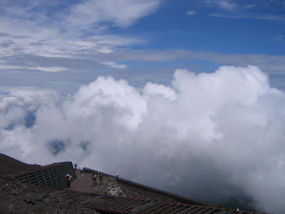
Here I've reached the top of the lower layer of clouds, and it was so cool to have these huge clouds literally right next to me!
Looking up the switchbacks, one can now make out hut after hut as the trail continues upward.
Another view of the row of huts as I get closer to the 7th station.
Finally I arrive at the first hut of the 7th station. It took me 30 minutes to get there whereas the map said it should take 80 minutes. They might have been referring to a different hut as the 7th station had a bunch of them. But still it seemed I was going about twice the pace of the printed times on the maps, so that gave me a good idea how long things should take. I felt like I'd be fine to get back down in time, and stopped worrying about speed. I didn't want to rush through this hike but really wanted to savor it, and indeed I did.
Here's a view looking down at the switchbacks.

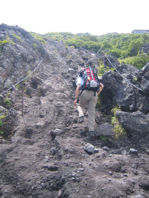
At the 7th station the character of the trail changed completely. Before it was mostly dirt, but now it changed to be entirely rock until the 8th station. To me this was by far the most fun part of the entire trail. It was very steep, and the rock was of superb quality. Nothing loose at all. It felt great just to touch. As you can see there were chains and other metal anchors in the rock, and I did find them useful to pull up on or for balance at times. Mostly I could just hike up, or grab onto rock to get up. This part was a blast!
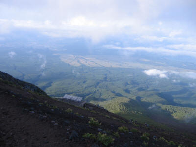
Higher up here's another hut at the 7th station.
And yet another one. I should mention that far from detracting from the trail, I thought the variety of huts really added a lot to it, and in a way were the highlight since otherwise the mountain is rather stark and monotonous. What I didn't like were the people smoking or playing radios or talking on cell phones, but fortunately there weren't too many of them.
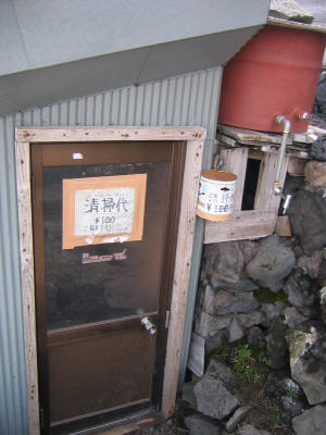
Every hut had a toilet, which was very nice. However each one requested a 100 yen donation (save for the summit which requested 200 yen!). Fortunately this was a warm day and I didn't drink too much so I didn't need to go to the toilet too much--otherwise the trip could have been quite expensive! It's pretty much impossible to go on the trail as everything is exposed and there were plenty of people everywhere, even on this day which was probably far less crowded than usual. I ended up going only twice, both at the "hon" 8th station (once going up and once down), at two different restrooms there, both of which were likely the nicest on the whole trail. The picture below is of a more rundown-looking one at one of the 7th station huts.
And below here's another hut, but this one is at the "hon" 7th station (本七合目), where "hon" I believe means "true". I'm not sure of the history behind all this. Okamoto-san said he tried to look it up on the internet, but was unsuccessful.
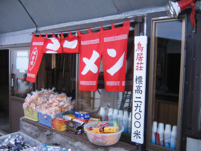
Here's an example of some things one can buy at a hut. The vertical sign says you are at 2900 meters, and the red sign says "ramen", one of my favorite foods, but I declined to try it on the hike. One place later on had ramen for 700 yen and instant ramen for 500 yen. I wonder if there was much difference. Notice the canisters of bottled oxygen lined up behind the glass. I saw some elderly people using these.
Looking down at the lower 7th station huts, and more scenery.
The rock trail continues. I loved it!
There were a lot of signs with strange English on them. This is one of my favorites. They are trying to say not to cut switchbacks.
Arrival at the 8th station. The benches at most huts were right next to vertical drop-offs, so I had to make sure to place my backpack and food carefully so that I wouldn't lose anything.
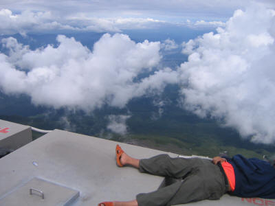
This picture isn't the greatest for scenery, but I like having the guy in it sleeping on containers in an area marked "No Entry" in both Japanese and English.
Here's a better picture of the trail below and the scenery.
Another 8th station hut.
Looking up there are still more huts above.
Another hut at the 8th station. A sign says it's 1 hour 50 minutes to the summit. Unfortunately I didn't record my time here, so I don't know how long it took from this point, but it was certainly over an hour, so I must have been slowing down as I got higher. Still, Fujisan is a good climb to do if you want to feel good about your strength. Most people climbing it are quite weak, so it seems like you're going very fast even when you are plodding along. Indeed no one passed me while hiking on the way up or the way down, although some people might have passed when I was resting and eating at some hut. Every now and then I'd see someone just behind me and think they were about to pass me, but then the distance between us would increase rather than decrease. Perhaps I had just passed them but it didn't register in my brain!
As I've done on other mountain climbs, the key for Fujisan, especially as the trail is so steep, was to just try to find a steady pace that I could maintain, no matter how slow it seemed. Even then I usually found myself going slightly too fast and would have to stop now and then to take a breath and let my heart slow down.
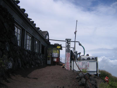
Arrival at the "hon" 8th station (本八合目), at 3400 meters. This is the Fujisan Hotel, which will be be a part of Bob Kimmel's story that I'll relate later on.
Drink prices at the "hon" 8th station. 400 yen for soft drinks and 600 yen for beer. Soft drinks would be 120 yen (for bigger cans) off the mountain, so a little pricey, but not too horrible.
I could start to see some of the famous "Five Lakes" from here. I believe this one is Yamanaka-ko (山中湖). I also could see and have a picture of Kawaguchiko (河口湖), but I didn't post that one here.
A look at a sign over the roof of the Fujisan Hotel.
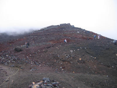
After the 8th station the trail changed to a combination of dirt and loose rocks, and switchbacked seemingly endlessly the rest of the way. It also started getting cold at this point so I put on my fleece. I would take it off again when I descending back to the "hon" 8th station.
Here's a nice sign; the upper one just says this is the ascent route, but the lower one says "Ato sukoshi de gooru!" (Just a little further to the goal!).

Despite the sign the trail seemed to continue forever, with the summit constantly out of sight, hidden in that upper layer of clouds. This was certainly the toughest part of the trail. You can see one causality sitting down here--he's probably suffering from altitude sickness. I know the feeling.... But I still was not having altitude problems at this point.
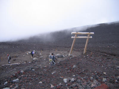
Finally one passes through a gate which seems to indicate the summit is near. This picture was taken looking down.
But still the summit seems out of reach.... Note that most people here are descending. As there is supposed to be a separate descent trail, I wondered why so many people were going down this way. What's more, I'd seen almost no foreigners to this point, which seemed strange since I'd read about 1/3 of those climbing Fujisan are foreigners. However near the top I saw a lot. I wondered if they just didn't understand which trail to go down, but then the Japanese tour groups were going down this way as well. I would understand later the reason.
Finally, just barely in the clouds, one can see the final gate marking the top of the trail.
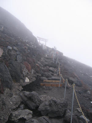
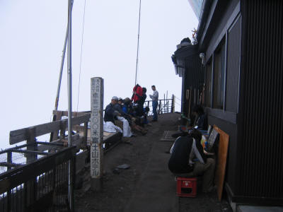
Arrival at the top. I made it to the gate at 1:52pm, so 3:38 to ascend the trail.
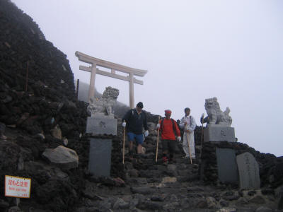
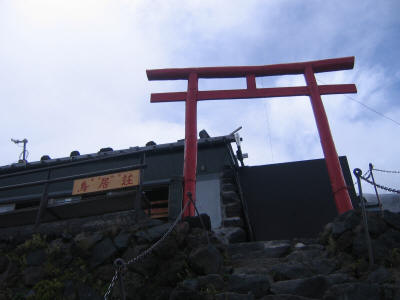
Marker at the top of the trail. There is also a Shinto shrine here, to the right. The marker says this is the summit, but it is not the true summit. Still I would guess the vast majority of people don't go higher than this point.
Of course what would the top of the highest mountain in Japan be without a lodge and gift shop?
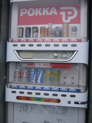
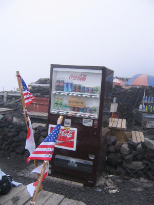
And I recall reading years ago someone being surprised that there's a vending machine on top of Fujisan, so I had to take a picture. Unfortunately I can't make out the prices even in the full-size photo, but I recall them being slightly higher than at the 8th station. Maybe 500 yen per can. The walking sticks with flags here are owned by members of some large group of US military men stationed in Japan, apparently, who were climbing together.
After resting a bit at the top I headed for a trip around the crater to the true summit. I went counter-clockwise since that seemed slightly shorter and I could stop by the lesser summit Hyakusandake (百山岳), at 3756 meters, first. However the path to Hyakusandake was roped off so I didn't make the short detour. The whole top was in fairly thick clouds anyway, so I could hardly see anything and was constantly worried I would lose the trail. Also there were almost no other people around, a big contrast to most of the rest of the hike. However the trail was fairly easy to follow. The wind started to blow here too, so it got even colder, and I almost thought of putting on gloves. It was actually kind of cool to have somewhat unpleasant weather at the top, since it felt more like a real mountain that way. I'm too used to the mountains in California with great weather at the summit, save maybe for some wind. However I couldn't really see into the crater, which was a big disappointment, and I also didn't take pictures this part.
I started to finally feel the altitude when walking around the crater, in particular when climbing up the steeper sections toward the summit. I'd get the same sharp pain near my temples and slight nausea that I recall well. So this must have happened around 12,300 feet or so. I'd had problems at a similar altitude the first time I tried Longs Peak. Maybe that's the limit for me without acclimatization, then, so lucky I didn't have to go higher! I only felt the problem when hiking upward--on flat or downhill I was fine. And of course once I descended I was really fine.
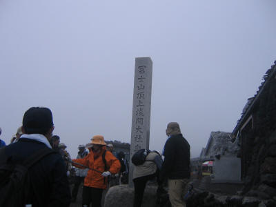
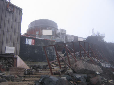
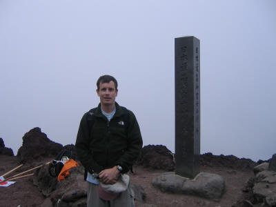
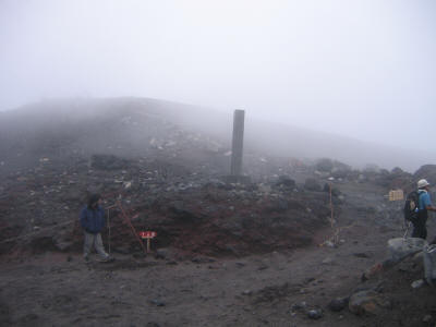
Finally I made it to Kengamine (剣ヶ峰), the true summit, at about 2:30pm. There is a weather station there. Kengamine is apparently the word to describe the rim of a volcano crater, but at least in the case of Fujisan it specifically refers to the highest point on that rim.
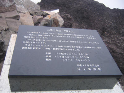
A plaque stating the height of Fujisan is 3775.63 meters (about 12,388 feet).
A group of three very nice guys (probably college age) were at the top taking pictures of themselves, so I took some of them with their cameras and they took one of me with mine. They told me it was fine to stand here but I should have stood closer to the summit marker. It says "Japan's Highest Peak: Fujisan Kengamine, 3776 meters". They told me they'd started up just after 9am and were impressed I'd started so late and made it up now. This is the first time I've stood at the highest point of any country. Since the highest point in the US is the top of Denali I might never stand there, but in fact I have yet to even reach the highest point of any US state!
Just after the summit there is a very steep downslope on the other side, the path made of rocks and sand. I found it too steep to go down comfortably and went to the edge where there was a chain and slowly made my way down holding the chain. The college students came behind me and tried running and sliding down the slope. Impressively they made it without falling. After that the trail was fairly flat until the junction with the top of the Fujinomiya (富士宮) trail. Here I looked at a map of the crater rim that had been placed there, and was surprised to find X's made with tape in the segment between the top of the Gotenba (御殿場) trail, which would soon follow, and the Yoshida- trail I was trying to get back to. Furthermore there was a sign in Japanese taped on that seemed to say the trail there as well as the top of the descent route of the Yoshida trail was closed to to construction after recent rockfall. I wasn't quite sure, though, in particular just what part of the trail was closed, so I asked a nearby older Japanese guy and he couldn't quite figure it out either. He said I should ask the clerk at the nearby hut. The clerk confirmed that the trail was indeed closed to to rockfall. That meant I had to go back the way I came, a longer route, which would make me later for the buses going back. Recalling my earlier thoughts that getting home would be more of an adventure than the climb itself, I immediately said to myself: "The adventure begins."
I considered going down the Fujinomiya trail but decided I'd better play it safe this time and go back the way I came. I rather dreaded re-ascending that steep scree slope back up to Kengamine, but it turned out to be easier going up than down. Also an advantage of retracing my steps is that the clouds had cleared a little and I could actually see my surroundings for the first time! I took a few pictures, then. I'm not sure if this one is looking into the crater or not (probably it's the other direction, so I was in the crater a bit), but it's still kind of cool.
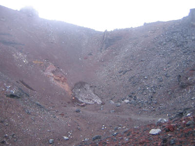
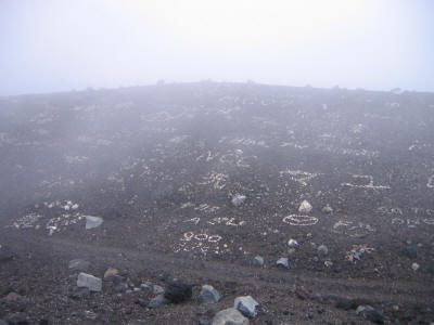
This next one is looking into the crater a little. I'd heard about how people write their names and words in large characters with rocks, so it was interesting to actually see it. I still couldn't see far into the crater, unfortunately.
When I made it back to the top of the Yoshida trail I went to check the other side. Sure enough had I tried to go clockwise I would have immediately ran into the trail being roped off, shown below on the right with the light-colored sign that says something like "passage prohibited". The red sign is pointing left and says descent route, but as can be seen this route is also roped off. I didn't see any explanation of why these routes were closed posted here, and there was nothing on the map of the crater at the top of this trail, unlike the notes posted at the top of the Fujinomiya trail. Now I understood why everyone was going down the ascent route. I'm glad though I didn't know about this until later. Had I known the full circuit was closed I might have just aborted and hurried back down, but I'm glad I did make it to the true summit and also saw a little of the crater.
Unfortunately I now had to descend the ascent route, which was very steep with a lot of loose rock. It was also very narrow, and there happened to be several large tour groups descending at the same time, going very slowly. I had to weave my way between the people, but fortunately everyone was very nice and let me pass when they realized I was trying to do so. I nearly slipped several times, but only fell once, and strangely I was just standing without really moving at the time. I fell backwards and caught myself with my hands, so no injury save a bruise on my left palm where it must have hit a rock sticking up. A very strange place to get a bruise, but fortunately a particularly unimportant place to injure.
After getting past the top part, there was a junction with the descent trail. The Japanese were all going that way even though it was roped off. However I could see the trail and that it connected again with the ascent route lower down, and it didn't look much better. Since everyone was going that way I stuck with the ascent route for a while and had it mostly to myself. At the next junction (around the "hon" 8th station, I think) I too joined the descent route.
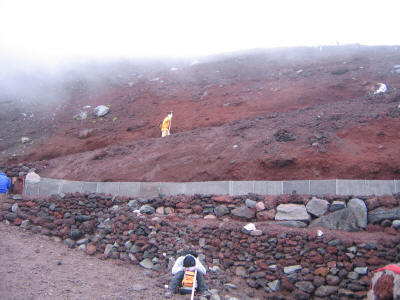
The descent route is very different than the ascent one. It is longer and not as steep, although still very steep in parts. It's a bulldozer road, and so quite wide and also made up almost entirely of sand and ash. There were rocks in some parts which made things trickier. But I found it surprisingly safe to run down--there was plenty of traction and one could stop fairly quickly if need be. Running down was not only faster but seemed to give less stress to my knees. So I mostly did that. However after a while I started walking more on the less steep parts, as running got both physically and mentally exhausting. Mentally because I had to be to be very careful just how I went down. I suppose with more practice I could it it with less attention.
The descent route has a whole different feel as well. It avoids all of the huts, so you feel more isolated from civilization on it. It's also more dull due to that, but at this point you just want to get down. There was a toilet facility around the level of the 7th station, but it smelled so bad I quickly passed it. Otherwise there wasn't much of anything. The clouds did clear a bit more though and I got some nice views, so I'd stop often for pictures. The one below shows part of the trail and some scenery. It's hard to tell with such a small size picture but there's a hiker standing on the trail here looking down.
Below is a different angle with more scenery. Very beautiful.
Eventually I reached a couple signs that said respectively 4.5 km to go and 2.7 km to go. This is the latter one. It took me a little less than an hour to get to the trailhead from the 4.5 km sign. That gives about a 3mph pace; not too bad.
Lower down there were a couple tunnels you were supposed to walk through to protect you from possible rockfall. There certainly where a lot of rocks perched up on the hill above. However none of the Japanese went through these tunnels, so I didn't either.
Eventually you merge into the ascent trail at the 6th station. This picture was taken either a little before that, or maybe near the very end of the trail; I forget. Anyway I'd made it back! Surprisingly the trip down took only 2:06.
I made it back to the trailhead at 5:31pm, so the entire hike took 7:17. However as I had guessed the adventure had just begun. I found the bus ticket office fairly quickly, but found it had closed at 4pm! There was a schedule listed outside, but I'd just missed the 5:25pm bus, and the next one wasn't until 6:25. I wasn't sure where to board, though, or if I could just pay the driver or not, and maybe the bus was full! However it seemed like there might also be other local buses going down to the station. As I had a lot of time I decided to try looking around and asking someone. Unfortunately the whole 5th station seemed to be closing down, and I could find no information center. The best bet seemed to be a building marked only in Japanese 管理センター, meaning Administrative Center. This turned out to be the information center as well it seemed, as they had maps and handouts. They were just about to close as well, so I got there just in time.
The older man in charge was very nice, especially when he found out I could speak Japanese. He said the Fujikyuu bus was the only one to take, and walked with me back to the ticket office. Seeing it was closed, he asked the driver of a bus which had just come in (for a different route) what to do. The driver said the buses left from there, and I could just pay the driver. I then went back to the Administrative Center, where the older man asked me if I wanted some coffee. I said I don't drink it, and he asked if I drink green tea which I do, and he said I was the first person he'd ever met like that. So he made me some tea and we talked in the offices there (the center was now closed) for about a half hour. There was a younger guy there in a police uniform as well. They suggested I take the train from Kawaguchi Station to Otsuki and change the JR line which would be faster than taking the bus. Of course it would be quite a bit more expensive as well, but they thought the bus might get caught in heavy traffic. I didn't know quite why this would happen on a Monday night but I prefer the train anyway. However I'd looked up the train schedule online and it seemed trains only left from Kawaguchiko once every 3 hours. They said no way, but they didn't have a schedule or internet access so the younger guy called up JR and found out the schedule. It was much more often than I expected.
Despite the fact that Fujikyuu runs both the bus between the 5th station and the train station, and the bus between the train station and Shinjuku (as well as the train itself to Otsuki I think) they don't synchronize things well at all. My 6:25pm bus would get into the station around 7:11, but the bus to Shinjuku would leave around 7:07pm! I'd have to wait for the next (and in fact last) bus at 7:59pm. The next train I'd be able to take only left a few minutes earlier, so I'd have another long wait at the station either way.
The older man asked me my hiking time and was impressed. He said most people take 6 hours to get up. I told him I wanted to bring my son in two years and he said even 5 year olds do the hike. He knew of one 7 year old who had just done it for the third time. Of course one couldn't do a day trip in this case. I hope I can bring my son here in two years have have him do the whole hike with a night at one of the huts.
The man mentioned they'd had to rescue someone--one 69 year old man in the US military group had hurt his leg or something like that and had to be carried to the medical center in a stretcher. At first I'd thought he was talking about something else I saw--a group of men carrying up an elderly woman on some kind of seat between two poles (I don't recall what it's called). She didn't look well so I thought she was injured, but maybe this was some kind of special event to take her to the top.
As the time to board got near I said goodbye and looked around the 5th station a little more. I was tempted to buy some food but just about every store was closed, and strangely I didn't feel hungry at all. I think the excitement of the day somehow gave me enough energy that I didn't need food. I just bought a drink in case I got thirsty on the way back, but I ended up only drinking a little. I finished off the last of my grape gummi on the way down. I had no trouble getting on the bus, which was only half full, and at the third station they stopped and picked up two young women, one Japanese and one German, who were trying to communicate with each other using very clumsy English.
I didn't run into Bob Kimmel on the trail (as I expected I wouldn't since the descending and ascending trails are mostly separate), and also not on the bus, so I got rather worried about him. Unless he turned around earlier than the top he likely couldn't have made it back down before dark, and he would have had the same trouble getting a bus back that I did. I sent him email to find out what happened with him, and found out that he did make it to the true summit, but stayed overnight at the Fujisan Hotel (which by luck had just started accepting credit cards earlier in the summer). He started up at 2am from there amid a huge crowd of other hikers, but unfortunately the top was still in the clouds and he was only able see a couple seconds of the sunrise. He then made it down and took the 3pm bus directly back to Shinjuku. Clearly the bus system is set up more for this kind of hiking style rather than the day trip I was doing.
Finally I made it to the train station, which looked new and was immaculately clean. So a very nice place to hang out while I waited. I ended up buying a train ticket to Shinjuku, which cost nearly 3000 yen, so almost double the 1700 yen bus ticket, but at this point I just wanted to get home as quickly as possible. I looked around for some place to throw out my trash, since there is no place on the mountain itself, but there were also no garbage cans here. I guess they knew if they provided any then everyone would be dumping their trash there.
I got my one good piece of luck in Otsuki, where I was able to immediately catch the Chuo Express train. This was not the fastest train (which would have cost an extra 1000 yen apparently) but it was nearly as fast and had the big advantage of going straight to Kanda. From there I took the subway the Asakusa and then the train home. For once it wasn't the last train! I forget just when I got back but it was probably around 11 or 11:30pm, so about 5 hours from the 5th station, or 6 hours from the end of my hike. A very long day.
I still had a great deal of energy left after the hike, and even when I got back home. I ate a little sashimi as a small late dinner. Overall Fujisan was one of the best hikes I've ever done. Not quite up to Half Dome, but then I may never find another hike as good as Half Dome. Still it was short and steep, just the way I like it, with a high-quality trail and interesting scenery. It would have been even better had it been less cloudy. I'd say it was quite a bit easier than Half Dome and the mountain hikes I've done near LA, mainly because it was so short. The ascent was similar in difficulty to Half Dome, perhaps, but the descent a lot easier and faster. Still it was a great workout, and extremely enjoyable. Supposedly there is a Japanese proverb that "A wise person will climb Mt. Fuji once, but only a fool will climb it twice" (Okamoto-san had never heard this one, so it is a little dubious). Well, I would certainly climb it again.
I never did add the websites that I referred to when researching this climb, and many of them probably no longer exist. There is an overall guide to Fujisan now available that is probably a good first source of information:
Distance up: 6.3 kilometers (3.9 miles)
Distance around crater and back:
4.5 kilometers? (2.8 miles?)
Distance down: 7 kilometers? (4.3 miles?)
Total distance: 17.8 kilometers? (11.0 miles?)
Time up: 3:38 (10:14am to 1:52pm)
Time going around crater: 1:33 (1:52pm to 3:25pm)
Time down: 2:06 (3:25pm to 5:31pm)
Total Time: 7:17
| Location | Arrive | Leave |
| Trailhead | 10:14 | |
| 6th station | 10:32 | 10:41 |
| 7th station (lowest hut) | 11:11 | 11:20 |
| "hon" 7th station | 11:38 | 11:41 |
| 8th station (Daiko hut) | 12:01 | 12:10 |
| "hon" 8th station (Fujisan hotel) | 12:50 | 1:01 |
| top of Yoshida trail (shrine) | 1:52 | 2:04 |
| very top (Ken ga mine) | ~2:30 | 2:40 |
| top of Fujimiya trail | 2:51 | 2:52 |
| passing Ken ga mine | 3:04 | 3:04 |
| top of Yoshida trail | 3:20 | 3:25 |
| "hon" 8th station | 3:55 | 4:04 |
| 4.5 km sign | 4:34 | 4:34 |
| 2.7 km sign | 4:50 | 4:50 |
| 6th station | 5:12 | 5:12 |
| Trailhead | 5:31 |