One disappointment I had with the Bay Area was that although it is surrounded by beautiful mountains (the Santa Cruz Mountains and the Diablo Range) there are no really big mountains nearby (the tallest is Mt. Hamilton at 4213 feet) and also no serious steep hikes like those I love in Yosemite. Yosemite was close enough that I could do day trips there, but I would have liked something close by, especially so I could strengthen my knees which cause so many problems going downhill on very steep hikes. The steepest hike I could find in the Santa Cruz mountains was Black Mountain, I think, and but it was not even close to strenuous enough.
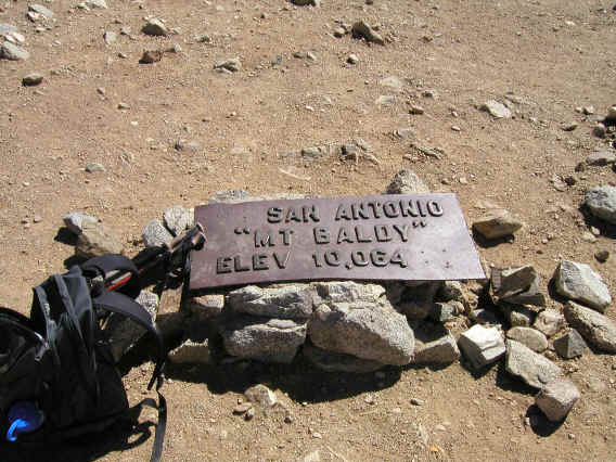
Amazingly I knew very little about Los Angeles before moving down here, and one big surprise was that there are some real mountains very close by! And not only that but plenty of long and steep hikes up them. When I first drove to Joshua Tree, I was amazed to pass by an extremely steep and impressive mountain that turned out to be San Jacinto Peak (10,804 feet). On a clear winter day I was again amazed to see a huge mountain visible to the east from where I live here--that turned out to be Mt. San Antonio (10,064 feet), better known at Mt. Baldy or Old Baldy from its lack of trees on the top. And I'd soon learn about the biggest peak in Southern California, San Gorgonio Mountain (11,501 feet). I bought some guidebooks (the best are Trails of the Angels and San Bernadino Mountain Trails, both by John Robinson) and found there are some excellent hikes up all three. Of course I had to try them.
In August I plan to fly to Colorado and hike up the Keyhole Route of Longs Peak with my friend Mike Vermeulen, who recently moved back there (he did the Keyhole route 4 times already when he was younger). This is a classic hike that sounds like it will be a great adventure. Partly to get in shape for that hike and partly just to enjoy the mountains here I decided to hike up the three peaks in order of height, one per Wednesday, with the hope that way of avoiding the crowds, which are supposed to be formidable on weekends. I found this order also to be the order of difficulty in getting permission to do the hikes! Calling the appropriate ranger stations, I found Mt. Baldy can be climbed with no permit, San Jacinto requires a permit but there is no quota and you can just self-issue one at the ranger station, and San Gorgonio has a quota and it's recommended to apply for a permit in advance by mail, which I did (although they said the Wednesday I wanted to go was wide open at the time I called--and in fact the permit arrived by mail when I was writing this). I have one more Wednesday left after these three before going to Colorado, and I may try a different route on San Jacinto that day.
This then is an account of the first of these hikes, up Mt. Baldy.
The guidebooks gave two good routes that could be combined into a loop: the Baldy Bowl Trail and the Devils Backbone Trail. The latter is apparently the most popular way to hike up Mt. Baldy, especially because you can use a ski lift on the weekend to cut the hike to about 6 miles round trip. I didn't want to use the ski lift anyway, and without it the Devils Backbone Trail is 6.8 miles one-way. The Baldy Bowl Trail is 5.1 miles, overlapping the other trail slightly at the beginning. So the Baldy Bowl Trail was clearly the steeper of the two, and since I love steep uphills but hate steep downhills, that set the direction of the loop.
To beat both the heat and rush hour traffic (since I'd take the 10 through downtown LA) I decided to leave early. I didn't make it to bed until 11:30 the previous night, but had no trouble waking up to the alarm at 4am. I started off at 4:40am after getting gas, and found the 10 freeway to be empty until 5am, when suddenly there was quite a bit of traffic, and this was when I was already past downtown. But no trouble going full speed and I got to Manker Flat, the trailhead, a little after 6am. Amazing to have such a mountain less than an hour and a half drive away, and that includes driving up to 6000 feet elevation.
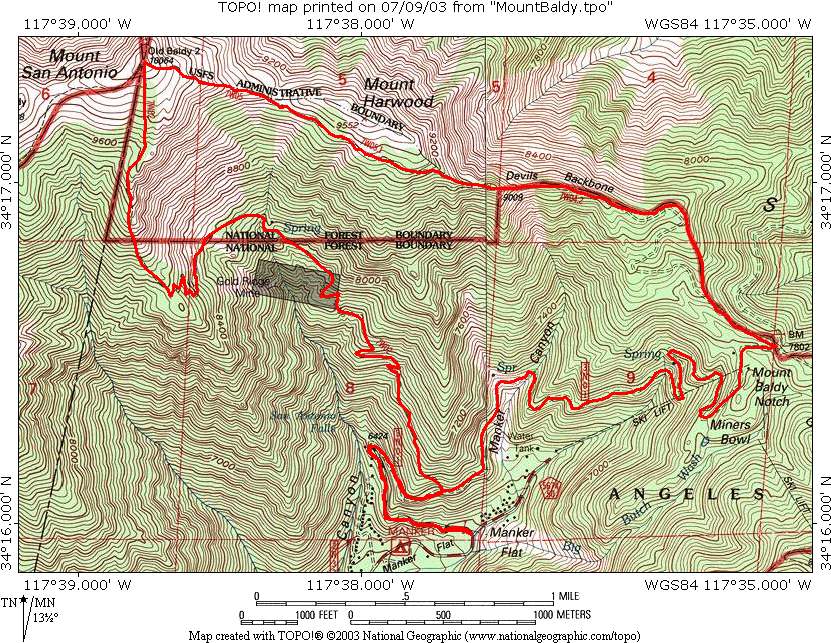
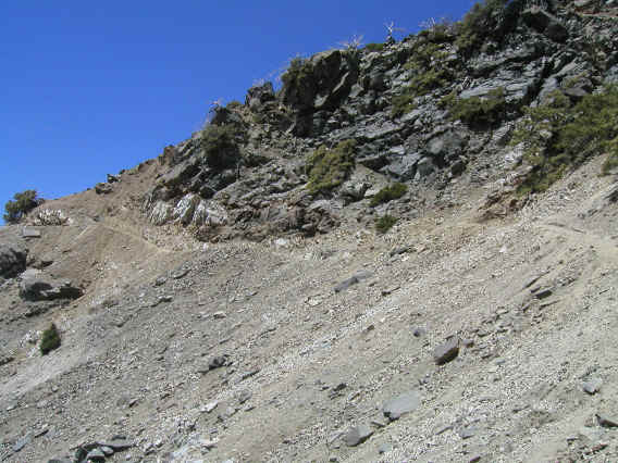
To be precise the trailhead is at 6160, so the net elevation gain is 3904. I set off at 6:20am. The hike starts and ends on a dirt maintenance road blocked by a gate, and after about a half mile you come to a small waterfall, San Antonio Falls. I took a picture but unfortunately it didn't come out well due to exposure problems in the early morning light. After about another half mile you come to the junction with the Baldy Bowl Trail. The guidebook mentioned the trail was unmarked, but what I saw was an extremely steep trail switchbacking up and I found it hard to believe that was what I was to take. Below is a picture of start of the trail, but somehow pictures don't give a good idea of steepness. I happened to have my GPS unit with me, and I'd set a waypoint at this junction in case I had trouble finding it. However I was distressed to find that the GPS placed me at the wrong location--and quite a bit wrong, like a mile away! I turned it off and didn't use it again. Fortunately I had a good map with me, the Tom Harrison Mt. Baldy map. The Baldy Bowl trail was apparently the only one in the vicinity, so I started up hoping I was right.
I soon came upon a register for those hiking to sign. It was the first time I've signed such a register. This indicated I was indeed on the trail. I also was looking forward to signing a summit register, which I've also never done. But on the summit I forgot to look for one. Maybe there isn't one on Mt. Baldy.
I was the first one to sign for the day, and my strategy of coming on a weekday to avoid the crowds worked beautifully--I saw almost no one the whole day! The first person I ran into was on the summit--he had come up the Devils Backbone Trail and said he only saw one person on his way up, a ranger. When I went down I ran into a couple people who were going up, but that was it. Almost the whole time I felt I had the mountain to myself. That was unbelievable so close to such a huge metropolitan area.
One disadvantage of being alone was when the trail got hard to follow, which happened a few times. Once it sort of disappeared into some scree. I went the most likely way but the branches that led to all seemed dubious. It had fooled at least one other person, though, as someone marked the area with a duck. I decided I'd better go back to the sure trail and look again. Finally I did find the continuation, which was hard to locate and went in the opposite direction I'd been heading. There were a few other places where the trail bifurcated, but fortunately these rejoined.
I had done Half Dome last month and made it up (7 miles gaining 4800 feet) in 3:45, so I expected with only 5.1 miles gaining 3900 feet I could get up in under 3 hours. Imagine my surprise then to find it took me 3:50 to get up, even longer than Half Dome! I think there were a few reasons. One is of course losing time trying to find the trail a few times. Another is that I'd been sick a week or two ago and so was not in the best shape. Another was of course the altitude--I could definitely notice it and I was forced to go pretty slow especially above 9000 feet. Indeed one purpose of these hikes is to get in a little altitude training, although I don't know how much it will help as the Longs Peak hike starts at about 9400 feet and goes to over 14,000 of course; I'd have to go to the Sierras to find something similar nearby.
Yet another factor is that I wasn't in any particular hurry and was stopping to take a lot of pictures (most didn't turn out well, though), although later on I had to stop a lot just to keep my heart rate down. I think the biggest factor was just that this hike, which was supposed to be the easiest of my three SoCal mountain hikes, was a lot tougher than I expected. The Baldy Bowl trail gains 3504 feet in 4.2 miles. For comparison the Four Mile Trail in Yosemite, which goes right up the side of a cliff, gains a mere 3214 feet in 4.8 miles, so this was actually harder! The Yosemite Falls Trail, one of the consistently steepest I've done, gains 2680 feet in the first 3.2 miles, for an average of 837 feet/mile, compared to 834 feet/mile for Baldy Bowl. So nearly the same, and if you go on to Yosemite Point at 4.1 miles you've only gone up 3000 feet. There were certainly parts of the Yosemite Falls Trail and Half Dome that were significantly steeper than what I encountered on the Baldy Bowl Trail, so maybe that's what made me think it wasn't as tough as them. But then the others have some flatter respites, whereas this one was perhaps more relentlessly uphill. Probably the steepest hike I've yet done is Mt. Dana (in Yosemite near Tioga Pass), which gains 3000 feet in 3 miles, and that took me a full 3 hours to go up, although that was also at higher altitude (10K to 13K feet) and the hike was 2nd class, despite what the guidebooks claim.
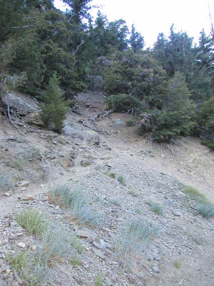
Well that was a little long (and mostly for my future reference), but I guess the point is that this hike turned out to be an excellent challenge. The scenery was fabulous as well, although I didn't get many really good pictures going up. You pass by an old mining site on the way up (which I think I missed seeing), as well as a ski hut. Next to that was a very nice bench carved out of a log, which was a good place to rest and get a bite to eat. Incidentally I usually take too much food on hikes and end up not eating half of it, so this time I opted to take only an energy bar, a beef stick, a small packet of cheese-filled crackers, and a candy bar, which I ate in that order and all by the time I reached the top. I found this was just enough and I didn't need anything on the way down. For some reason the cheese crackers tasted particularly good on this hike. As for water I brought 3 liters (the same I bring for Half Dome, which is just barely enough) and found it to be just barely enough again. I passed a little water on the hike but was glad I didn't have to deal with purifying it. I also brought extra clothing (fleece, rain jacket, wool cap, etc) that I knew I wouldn't need but will be bringing up Longs Peak so I wanted to get used to the weight.
The weather was great the whole day and the air had that fresh pine smell that's so wonderful. Since the Baldy Bowl Trail is to the west of the peak, the mountain blocked the sun for most of the way up so it was nice and cool. And when I got up high enough to reach the sun (which was coincidentally right about when the trees ran out) the temperature was low due to the elevation. There was also a nice breeze. It only got hot at the very end, walking back down the unshaded maintenance road. The sun was fairly harsh and I stopped to put on a second coat of sunscreen on the way down. No sunburn fortunately.
One annoying thing was the flies. Fortunately there seemed to be very few mosquitoes, and those seemed isolated to just the lowest elevations, but there were a lot of flies and similar insects, and most of the time it seemed some group of them was buzzing around my head. Mostly it was just the noise that was annoying, but it was annoying nonetheless. I'm not sure insect repellant would help, and it doesn't seem worth the bother in any case. In certain sections of the trail I could hear a much louder buzzing sound coming from the trees above. This was actually a little scary--I worried I might be attacked by some swarm. Fortunately nothing happened.
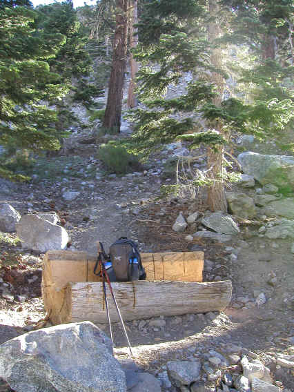
After the ski hut is Baldy Bowl, a large treeless area southeast of the peak that the trail is named after. The picture below doesn't do it justice. Apparently it's popular for skiers.
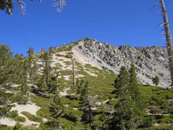
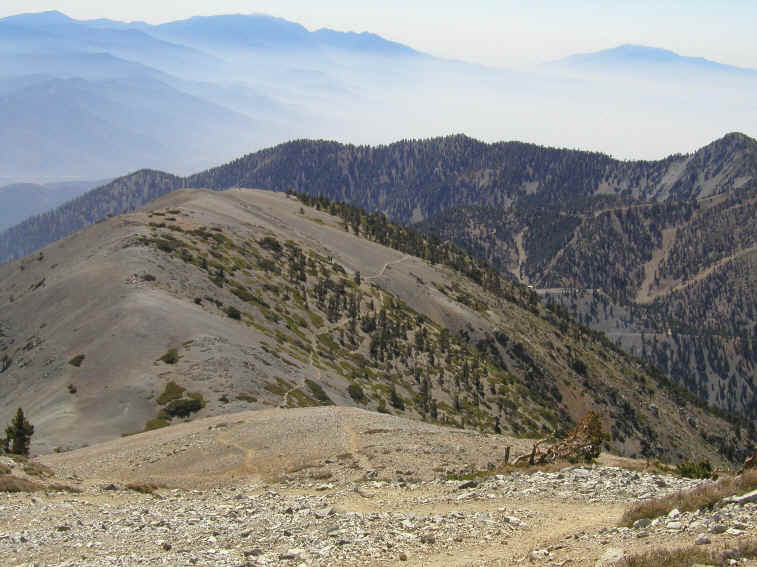
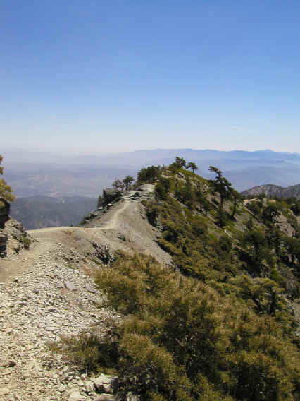
You hike up the left side of Baldy Bowl and gain the ridge. Then there's still a steep hike left to the summit, shown below.
Of course I had to take a picture of summit marker.
The views from the summit and the Devils Backbone ridge are outstanding, and there's no way pictures can do them justice. I took many, and here are a few that came out decently. The first two (which are connected) show the view to the northwest and north.
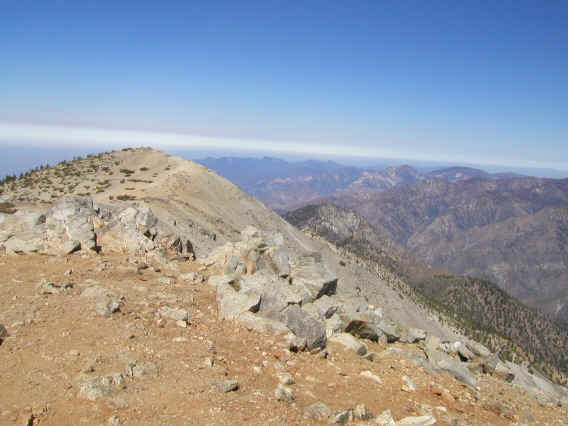
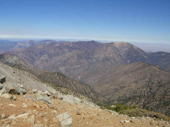
Below you see there's no trouble picking out the trail down the Devils Backbone. This is my favorite picture of the day so I've reduced it only 1/9 versus 1/16 for the others. To the right you see the Mt. Baldy ski area. I'm pretty sure the peak in the right background is San Jacinto, and the rounded peak in the middle left is San Gorgonio. So I got to see the summits of my next hikes!
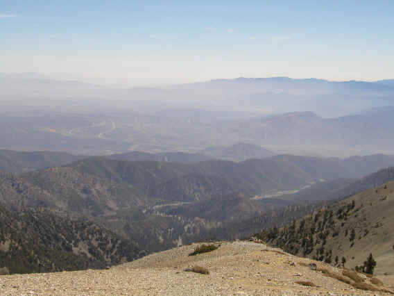
A view down into the Mojave desert.
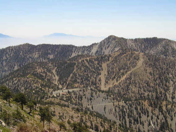
Closer to the ski area. San Jacinto Peak in the background.
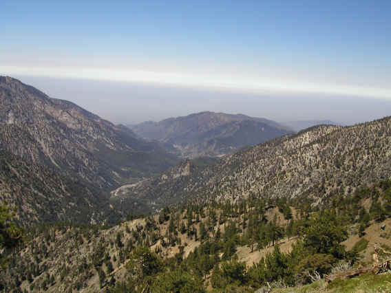
Looking down Manker Canyon to the southwest.
Below is one area of the trail that was a little scary. The trail here is very narrow and tilted toward the dropoff, which is steeper than it looks in the picture. I'm sure with more use this section will get even more dangerous. One other scary area was when the trail turns into a maintenance road just before the ski area. I thought it would be easy going from there, but the dirt/gravel road was extremely steep and went straight down. Amazing they can get vehicles up it. Footing is very loose and I slipped a couple times, but managed not to fall.
Here the trail goes right on top of a narrow ridge. This wasn't too scary since the trail was wide enough and flat. Terrific views to both sides. It would be more frightening in high wind; it was a bit breezy but only enough to worry about losing my hat.
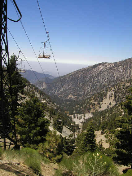
Here's the ski lift that if it were running (weekends only apparently) could whisk me back down to my car. A little tempting--in fact since I love uphill and hate downhill such transportation seems ideal! But I wanted to do the full roundtrip, which meant following a winding dirt maintenance road a long 3.6 miles back to my car. Unlike the earlier segment the road was very gently graded (you lose only about 1200 feet), and this was one of the easiest downhill trails I've done. So a pleasant way to end the hike.
I got back to the car at 1:15pm and drove back. Midday traffic was not bad at all--lots of cars but going full speed almost the whole way. I got back before 3pm.
Overall a fantastic hike. I'm looking forward to San Jacinto and San Gorgonio.
Distance up: 5.1 miles
Distance down: 6.8 miles
Total distance: 11.9 miles
Time up: 3:50
Time on top: 0:15
Time down: 2:50
Total Time: 6:55