The idea to do this hike surely has the most unusual genesis of any I've done. In a way it goes way back to my undergraduate days at MIT (probably around 1986, so 20 years ago!), when I tried listening to Wagner's Ring for the first time. I loved parts of it right away, but found it dull overall (interestingly I skipped Siegfried, which would become with Das Rheingold one of my two favorites of the four) and lost interest. I recall around that time Robert Jones, the professor teaching a 20th century French literature class I was taking, and who was a huge opera fan (he had a room, maybe more, with shelves filled with opera recordings on record), telling me that opera is something that sneaks up on you and addicts you. I wondered if it would ever happen to me.
I didn't really start to seriously like classical music until much later, just a couple years ago, and opera took a little longer still. I eventually tried out Wagner again, this time on DVD (much better than listening to it--pure listening to opera is somewhat perverse) and found I liked him much more. At first there seemed to be a lot of relatively uninteresting filler between the "golden moments" (as my friend Joanne Hou worded so perfectly) of tremendous music, but I found as I listened more and understood more that more of the music became interesting and beautiful as well. I started with the Ring again, but this time tried out his other works and found them also to be superb. I could still mostly only take Wagner is short doses, meaning an hour or so at a time, but I reached the point where I felt I could actually sit through and enjoy his operas in real time. He also became one of my favorite composers, and The Ring especially as one of my top few very favorite works.
I learned sometime in Spring 2006 that the Kirov Opera under Valery Gergiev would be presenting the entire Ring cycle at the Orange County Performing Arts Center, and when I found there were still tickets left I immediately drove down and bought the cheapest seat. It was $308 for the cycle which was a shock to my wife, but then she felt better when I showed her the most expensive seats were $6300! (that includes a mandatory $5000 "donation"). I was a little worried I'd be sick of Wagner by October when the operas would be presented, but couldn't pass up this opportunity. Indeed I didn't really listen to music much at all over the summer, spending all my free time hiking, but by the time the operas came around I was in the mood again.
My biggest worry was the usual biggest worry in LA: traffic. I'd have to drive 46 miles to the hall down the 405 freeway, famous as the most congested in LA, and what's more do that right around rush hour for two of the performances. By luck I was talking with my former UCLA officemate, Dave Weisbart, who had just returned from Norway, and I found he was now living in Irvine with his fiancée Christine Charvet, who is now a grad student at UC Irvine. He offered to let me stay with them. I didn't want to intrude too much, but I asked if I could stay Saturday and Sunday nights. Because the performances were spaced out (Friday, Saturday, Monday and Wednesday) this meant I'd only save one day of driving and have to impose on them for two nights, but on the plus side we would have Sunday free to do something together near Irvine. Dave also loves to hike fast and is in very good shape, but we'd never hiked together before as far as I can recall, even during a math department hike. I looked for good hikes to do around Irvine, and immediately found Santiago Peak, at 5687 feet the highest point in the Santa Ana Mountains (which I'd never been to before) and also Orange County. As I'd been to the highest points of five other mountain ranges nearby this summer (the Santa Monica, San Gabriel, San Jacinto, San Bernadino, and Sierra Nevada mountains), not to mention Mount Fuji, this seemed like the perfect addition. Via the recommended Holy Jim Trail it was a fairly long hike of 16 miles roundtrip with 4000 feet elevation gain, which seemed perfect for me, and Dave agreed to do it (unfortunately Christine declined to join us). The only bad part was the approach--the last five miles are along a dirt road for which high clearance is recommended. I'm actually just about to buy a RAV4 just for this reason, but don't have one yet. Still from what I read a passenger car should be okay if one drives slowly and carefully. Dave's Camry seemed to have slightly higher clearance than my Civic, so he very kindly agreed to sacrifice his car. It's interesting that the drive from Irvine took only about a half hour to get to the dirt road, but then an hour or more to do those last 5 miles. It wasn't as bad as I feared, but still very unpleasant with a few worrisome sections (we were about the only passenger car on this road the whole day, for good reason). We made it fine, but I'm looking forward even more to that RAV4.
We got a very late start so I was worried we might not make it down by dark. We didn't start until noon and the hike at 16 miles could take 8 or more hours. I brought a flashlight just in case. In fact I brought all sorts of stuff including cold weather and rain gear, and 3 liters of water, again mostly to practice carrying weight, although it couldn't have weighed much more than 15 pounds (including 11 for the water). Dave and I were complete contrasts during the hike. He was very "old school", wearing jeans, cotton socks and a tee shirt, and carrying just a 1.5 liter bottle of water (he drank an energy drink and more water before the hike started). I was the "new school" hiker with my high-tech clothes and equipment. Of course we were both fine. It turned out to be a fairly warm day so I drank about 1.5 liters as well (Dave just finished off his bottle). The weather was just about perfect. It turned out the hike was much easier than I expected. The trail is very high quality almost all the way, and doesn't seem steep at all save for just a few very short sections climbing out of gullies. One can walk at pretty much the same speed as on a city sidewalk! Dave (who used to trail run so he could go a lot faster) let me set the pace and we were able to make good time.
Surprisingly for a Sunday afternoon we met very few other hikers. Aside from going to the summit, a popular and much shorter hike is to go to the Holy Jim Falls, and there was a group of hikers doing that. This was apparently some kind of singles group, and they invited us to join them, but they were going much too slowly. The group was mostly women, and they seemed quite nice and attractive, but they seemed interested in Dave rather than me for some reason.... Of course Dave is engaged and I am married, but it would have been fun to hike with them a little if our speeds weren't so different. We took the side trail to the falls which added an extra half mile and 15 minutes or so (that part is slow as you have to make several creek crossings) but was well worth it. We ran into the group once more at the junction, and one guy who seemed to be the leader told us it takes him about 6 hours to do the hike, quite a bit faster than I would have expected given the distance.
Above the side trail to the falls we didn't see another hiker! There were some mountain bikes, though. And eventually the trail intersects with a dirt road that you take the the summit, and that allows car and motorcycle access to the summit and seems quite popular as an easy off-road route. So the only bad aspect of this hike is being passed by cars and motorcycles which of course create a big cloud of dust and dirt as they go by.
Dave and I really enjoyed the hike and had a very nice conversation about math, physics, and all sorts of other things. At some point a little before the road, I think, on the way up Dave stepped on some big rock badly and seemingly twisted his ankle. However it turned out he'd actually twisted his knee, and he started to get stronger and stronger pain on the side of his knee. Although it was no doubt different from my own knee problems I've had (which are also on the sides) I could empathize and the pain he was feeling seemed very familiar. Unfortunately although I'd brought a lot of first aid stuff I didn't have anything that would be helpful to him, such as an ace bandage or ice or Alleve. So he just had to hike through the pain. Every now and then he'd have to stop and rub the knee for a while, so our pace slowed considerably, but we still made the summit in just over 3 hours, surprisingly fast. I find it a little hard to believe the trail is really 16 miles. Actually Jerry Schad's guides (including 101 Hikes in Southern California, which I have) say 15.0 miles, and as I only started timing from the signed trailhead rather than the connecting dirt road from where you park (which probably adds another mile roundtrip) that might account for the difference, although it still seems high. But then the trail is very easy and you can go really fast. We took the side trail to the falls also, so I'll just leave the distance as ambiguous for now.
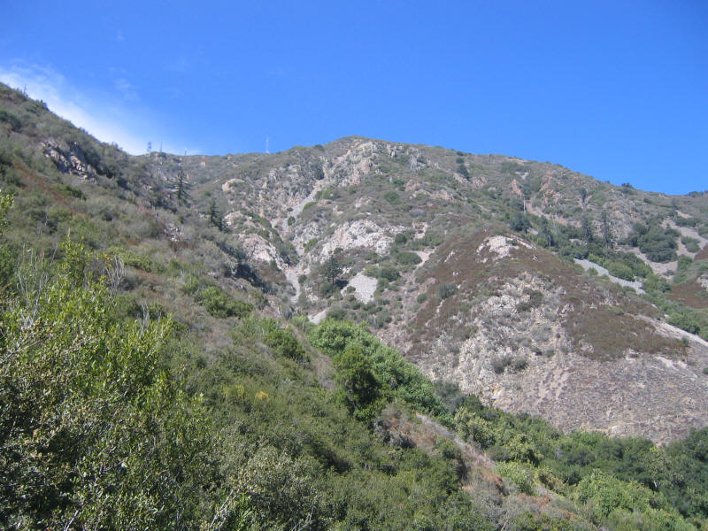
Finally here are some pictures. First here's a view of the summit from partway up the trail. You should be able to make out lots of antennas on the top. Since this mountain has an unobstructed view of most of the valleys below it's a very popular place for antennas.
In fact it wasn't clear just where the true summit was, but probably there was an antenna there so we couldn't have stood on that point. We wandered around a bit among all the structures, and chose the place below for lunch. Dave and I finaly finished off the last of the food I'd bought in Lone Pine for Mount Whitney--some dried fruit and a Cliff bar. I brought some Cheez-Its and senbei/peanuts as well, and for once ate everything and still felt a little hungry.

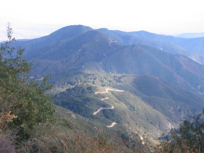
Although our lunch spot may not seem so great, it was in the shade and had a nice view, which Dave is posing in front of below. It's a bit hazy but you can see I believe San Gorgonio Mountain in the distance here. I first thought it looked like San Gorgonio, then thought we couldn't be close enough, but then looking at a map later we were indeed close enough and that must be it! The lake is apparently Lake Matthews.

On the way down the scenery was beautifully lit by the afternoon sun. The camera didn't capture it well, unfortunately, but here's the best of the attempts.
I didn't expect the Santa Ana mountains to be so beautiful. They are really cool in that they're a range disconnected from everything else, so you get great views in all directions plus the range itself is really stunning. I might not have hiked here for a long time, so it's thanks to Wagner and the Ring of all things that got me out there now!
Since the trail was so good Dave for the most part was able to go quite fast--just on steeper sections or switchbacks he had to slow down. We made it back to the trailhead at just after 6pm and then to the car not long after that, and made it to the end of the dirt road just before it got dark. Except for that dirt road this was a terrific hike that I highly recommend for its combination of scenery, length, and ease of going fast. I'll certainly be back.
Roundtrip distance: 15-16 miles
Elevation gain: 3950 feet
Time up: 3:03 (11:58am to 3:01pm)
Time on top: 0:35 (3:01pm to 3:36m)
Time down: 2:27 (3:36m to 6:03pm)
Total Time: 6:05