My first three long bicycle rides were spent mostly going down Highway 1 from San Francisco to Santa Cruz, and crossing the Santa Cruz mountains via four different routes (plus going around them once). I thought a nice theme for the next three would be to climb the three main distinct peaks in the Bay Area, all of which are conveniently not in the Santa Cruz mountains. These are of course Mt. Hamilton (4213 feet), Mt. Diablo (3849 feet), and Mt. Tamalpais (2586 feet). They are listed as the "Big Three" Bay Area climbs on the King of the Mountains page.
I've actually never gone up any of these peaks, even in a car, so this should be a lot of fun. All three are supposed to have spectacular views, especialy Mt. Diablo. I read in one book that supposedly Mt. Diablo is second in the world to Mt. Kilamanjaro as to the area of land visible from the top. The problem for all three will be the usual Bay Area haze--only very rarely can one see for long distances here. Let's see if I get lucky.
A nice thing about living in Palo Alto is that all three of these peaks are within a reasonable cycling distance. Furthermore the total distance is inversely proportional to the height of the peak, which is nice. However if the total climbing of the route is considered, rather than just the peak itself, this does seem proportional to the distance, so these trips should increase in difficulty if I do them in the planned order.
The three routes are just perfectly arranged in that they cover the South, East and North Bays. The only area missing is the coast and Santa Cruz moutains, where I've already spent plenty of time. So these trips will be a nice introduction to new areas.
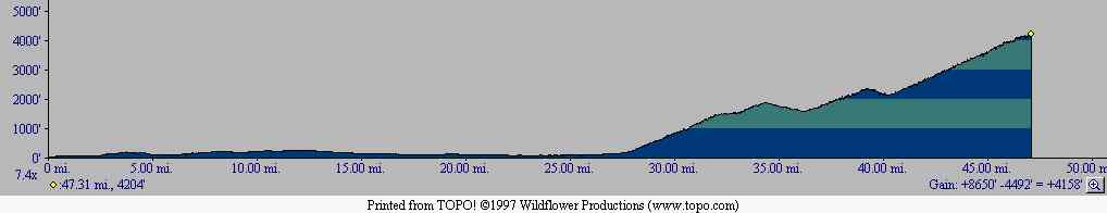
Distance of the route shown is about 47 miles. I'll probably take slightly different routes both to downtown San Jose and back, and try to extend the entire trip to be over 100 miles for aesthetics. Let's hope there aren't big headwinds coming back.
May 16, 1998.
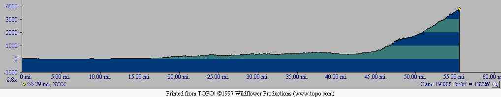
Distance of the route shown is about 56 miles. I won't quite follow the route through Fremont, as the Topo maps are somewhat old and don't represent the most recent roads in that city. Also I'll take a slightly different route home, visiting a friend in San Ramon on the way back.
May 24, 1998.
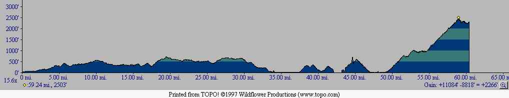
Distance of the route shown is about 60 miles. The route there is more or less the route of my first trip to San Francisco, until I get to the North Bay. As you can see unlike the other two routes there's a reasonable amount of climbing before reaching the mountain itself. To get home I'll probably take a very different route closer to the Bay (and thus much flatter), or else Caltrain if I'm worn out.
May 31, 1998.
All three trips were successfully completed. I'll post more information on them later, but for now there are some pictures I took:
Return to John Leo's Cycling Page