For detailed background on this hike, see my Mount Shasta trip report. In brief, I became very interested in climbing this mountain a year ago, read as much as I could about it and watched the Ascend Rainier DVD countless times. I intended to go with a guide service, but by the time I was ready to sign up everything was full, so I took a snow travel class and decided to climb Shasta this year instead, saving Rainier for next year, which in a way made more sense. However I couldn't resist visiting Rainier this summer and climbing at least a little way up. I learned that the climb to Camp Muir at about 10,000 feet was on a snow field with no crevasse danger, and that I could likely go that far safely alone. The books I had on Rainier were mountaineering books in which the hike to Muir is a minor detail, but I did find some information on the web and also, at Powell's in Portland, took a look at a couple hiking books on Rainier. It seemed the Camp Muir hike is a popular day hike and I should have plenty of company. I deliberately chose to go on a Friday to avoid the worst weekend crowds.
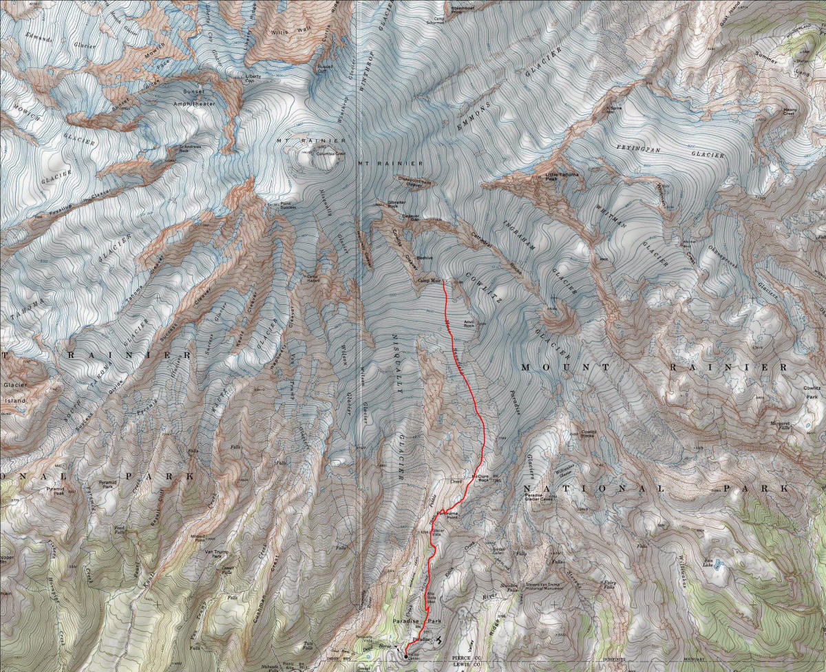
I was less worried about this hike than any of the others I planned (Shasta, Hood, Adams--although I only did Shasta) since I was only going up to 10,000 feet. The main worry was the weather, particularly in a whiteout one could get lost and wander into more dangerous terrain. The park service has an excellent map with compass bearings (available here) which I picked up at the visitor center. There is also an excellent map of the entire climbing route that I didn't find until now. Also invaluable is head climbing ranger Mike Gauthier's terrific blog which contains updated climbing conditions and news, including information on the Muir Snowfield itself. I was so impressed by the effort Gauthier put into this blog that I bought his book Mount Rainier: A Climbing Guide, even though I normally avoid books on just a single mountain. However if any mountain deserves its own book it's Rainier, and this one is excellent so I'm glad I purchased it. If it's still available check out the July 30, 2007 entry in the blog, titled "Excitement at Camp Muir", to see that the weather was superb the weekend I climbed. Of course I'd deliberately gone at this time to get the best chance at good weather, and it had paid off.
Like Shasta (14,162 feet), Rainier (14,411 feet) dominates the surrounding area for hundreds of miles. It's surprising how quickly the heights taper off after Rainier: In Washington and Oregon combined, the next highest peak is Mount Adams (12,276 feet), over 2000 feet shorter! Then comes Mount Hood (11,239 feet), the tallest mountain in Oregon, and Mount Baker (10,781 feet), in northern Washington. All are volcanoes. I could first see Rainier from Portland (about 100 miles away), and it was already impressive; it was particularly stunning from Tacoma, about 40 miles away. Unfortunately unlike Shasta I didn't get any pictures or video of Rainier from a distance, although we had our chances.
We stayed with my high school friend Joe Grabow and his family in Redmond for a couple days, and then drove down to Rainier Friday morning. We left around 9am and it took about 3 hours to get there, longer than I expected. That's about the same time as it takes to get from my place in LA to Mount Whitney. The distance is shorter, but the problem as with so many trips to mountains is that you get stuck for a long time on two-lane roads with slow traffic. The final road leading into the park seemed endless, but at least the scenery is beautiful.
We arrived about noon, then. My original plan was to hike a little with Kyoko and Kyle and then continue on my own, letting them find their way back, but it was late enough that I thought it best to just get started on my own right away. I stopped in the visitor center to pick up the compass bearing handout and another one on Paradise Area Trails, and also filled my water bottles (two liters, which was just fine for this hike). I started off just before 12:30. I wasn't sure how long the hike would take me--the handout said 6 to 8 hours and recalling that Shasta took longer than I expected I said I should take 6 or 7 hours. Kyoko and Kyle ended up exploring the visitor's center, eating lunch at the grill there, and relaxing and sleeping in the car. They also tried to hike a little, up the Deadhorse Creek Trail, but found it very steep and had a lot of trouble with mosquitoes. Strangely I had no trouble at all with mosquitoes, although I did note there were a lot of insects around, even on the snowfield and at Camp Muir!
I brought less equipment than for Shasta. I wore my normal hiking pants rather than the insulated pants (the weather forecast called for temperatures of around 50 at Camp Muir, and it was in the 70s lower down), but brought the rain pants to glissade in. For the top just a hiking shirt, lightweight fleece, and rain jacket; I left the softshell jacket behind. No crampons as I'd read they weren't needed in the current conditions, and indeed they weren't. No helmet either. I did bring my ice ax but never used it; the trekking poles were perfect. I wore my mountaineering boots but with lightweight socks and no liner socks. I decided to just wear my normal sunglasses rather than the makeshift duct tape glacier glasses (although I brought those as well). I wear them over my normal glasses and so light gets in at the edges; I wanted to gauge just how important it was to wear glacier glasses on a snow field and figured this trip was short enough that I'd get an idea without going snowblind. Indeed I was okay, although at the end it seemed (maybe it was my imagination) that the outer edges of my eyes hurt a little. I'll get some prescription glacier glasses made before my next snow trip.
It was a good thing I'd picked up the trail map handout as there is a maze of trails in the Paradise area. I had a National Geographic map of Rainier (the most beautiful topo map I own--just looking at it made me want to climb the mountain!) but it was good to have something with these trails in more detail. I was starting from the Jackson Visitor Center instead of the Paradise Inn parking lot, which meant I had to take the Alta Vista trail first to get to the Skyline Trail, but even then it wasn't clear just where to start from (the trailheads are not well-marked) and the signs at junctions were not always clear. I ended up starting at the wrong trailhead but quickly got back on track.
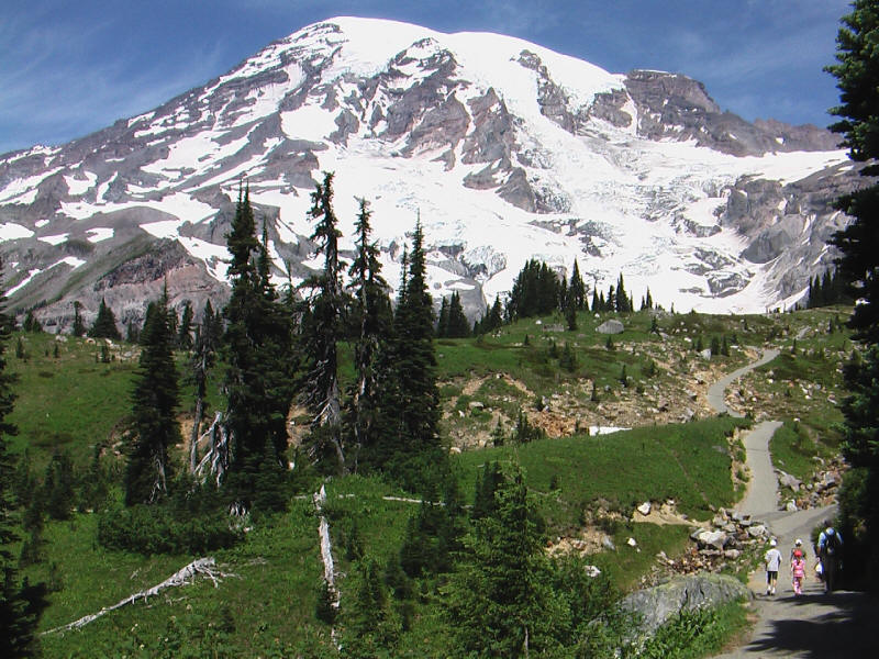
I had very high expectations for Rainier and from the start it surpassed them easily. I'd seen pictures and video of the mountain but nothing could remotely compare to seeing it in person. It was absolutely spectacular, especially the contrast of the lush green forest around aptly-named Paradise with the stark grey and white upper mountain. What's more wildflowers were in bloom making the scenery even more stunning. The weather was perfect and it seemed I'd gotten lucky and picked an ideal day to do this hike. I took a lot of video and many pictures. The video (just a few samples of all I took) will only be available for a limited time and it is very large (tens of megabytes per file so you need a fast connection) but I recommend looking at it if you can.
Here is a picture of Rainier from lower on the trail, showing well the contrast of green and white.
Here is a video taken a few minutes before that picture, and another video taken shortly after the picture.
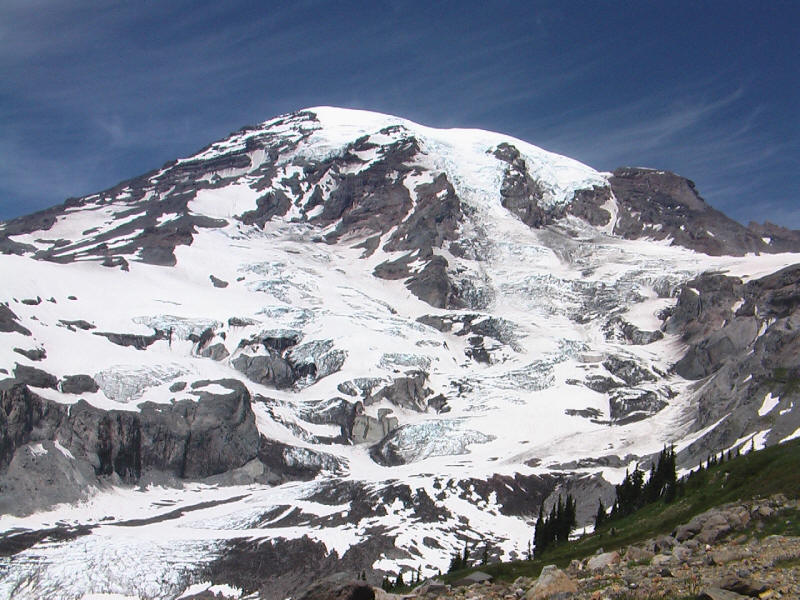
Higher up, more detail of the mountain.
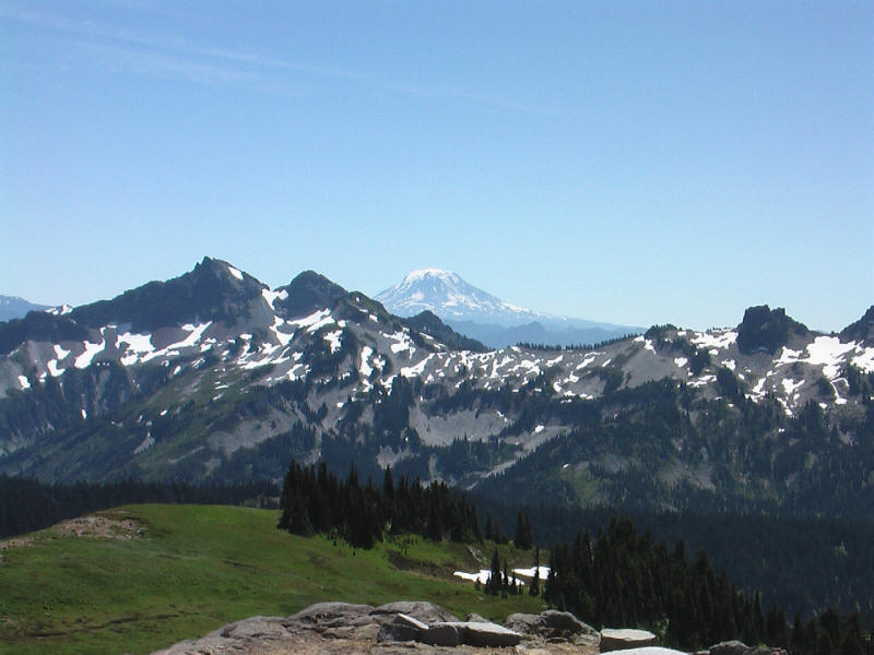
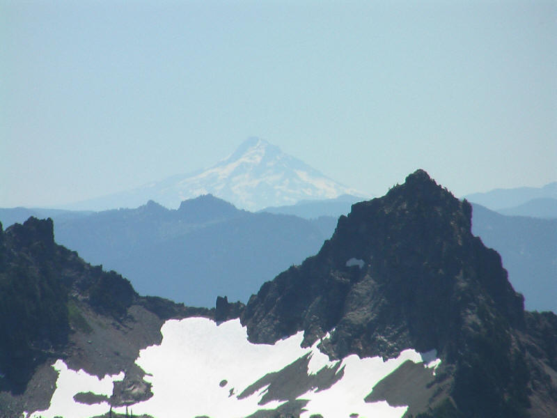
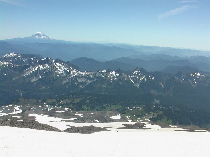
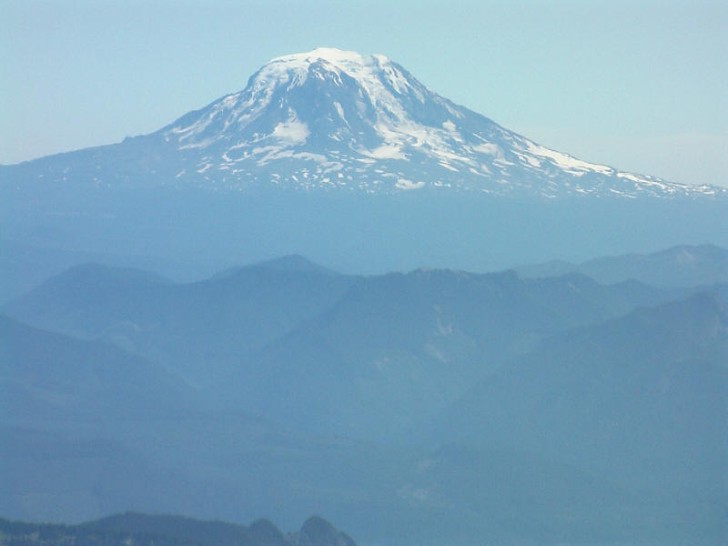
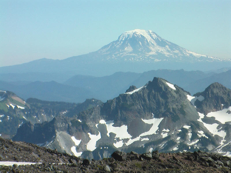
The biggest surprise of the hike was how well I could see three other great volcanoes from it. The most impressive was Mount Adams, one of the volcanoes I'd wanted to climb this trip but didn't. Here is a shot from the trail as it comes mostly into view.
Mount Hood, the highest point in Oregon, is more dimly visible as it is farther away. This is the other mountain I'd planned to climb but didn't this time (as explained in the Shasta report). Next time for sure!
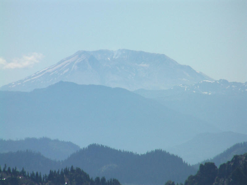
I'd also thought of climbing Mount Saint Helens (8365 feet) but was worried I couldn't get a permit. It was also nicely visible and here is a zoom in on the remains of it.
And some video:
As you can tell from the video I had trouble just figuring out where the snowfield was, but that was because it wasn't really visible until high up on the trails--it was farther to the right of what I could see. The trail was mostly melted out to Pebble Creek, but there were a few patches of snow including one that tilted somewhat steeply to the side. I arrived at Pebble Creek (which is 2.3 miles from the Paradise Inn, but over 2.4 miles from where I started so I've declared the overall hike to be 9.2 miles instead of 9) in a little over an hour. It was a steep hike (gaining almost 2000 feet) but I love steep hikes, and it was very high quality along with being incredibly beautiful. But the fun was just beginning.
After a short break to eat some snacks I crossed the creek and started up on the snow field. The Muir Snowfield gains 2800 feet in about 2.2 miles, which means a little over 24% average slope. I must say it didn't seem that steep to me. Some parts seemed almost flat, which means there must have been other parts at over 30%, but nothing seemed really steep. After Shasta it was a piece of cake. Perhaps the steepest part came right at the beginning, and there was a narrow snow trail angling up part of it. Here I ran into a guided group of older guys coming down, and decided to step aside (somewhat tough to do) and let them pass. One of the guides told me I had the right of way as I was going up, but I've read in other places that people going down have right of way! Maybe different mountains have different local customs, but it's good to know Rainier's now. I asked the guys if they'd come from the summit, and they said no just from Camp Muir. They also had smaller backpacks than one would need for a summit climb, and the guide service was one I didn't recognize--only three are allowed to guide to the summit, but I guess others can guide shorter climbs. One guy when I asked how it was going said he felt terrible, and indeed the group looked pretty tired.
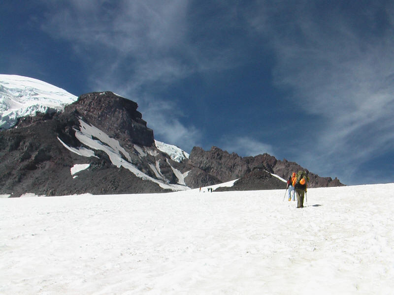
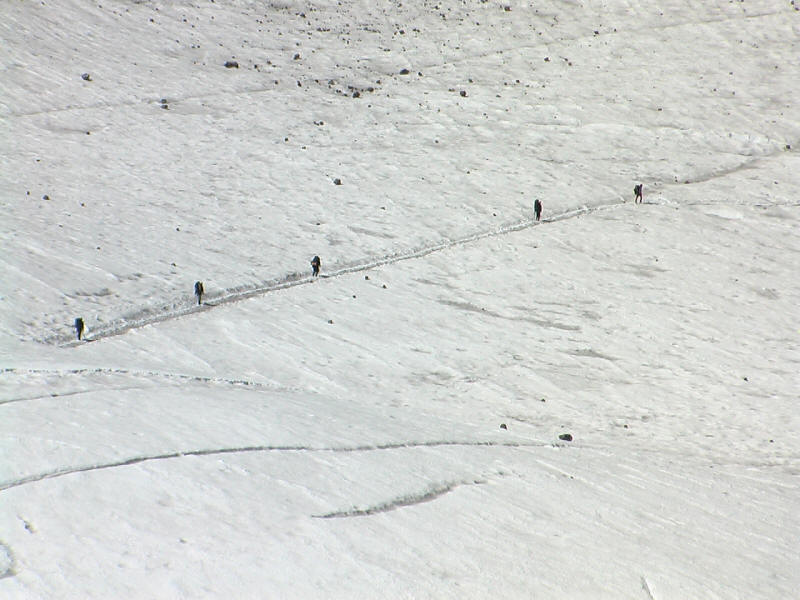
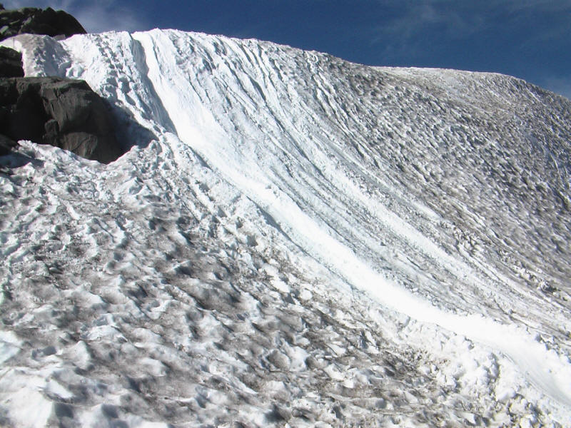
This was perhaps the only bottleneck on the entire snowfield, because after the steep section it opened up completely. I could see right away why the terrain is described as deceiving. It was hard to tell just where to go even with perfect weather, and I can imagine in a whiteout it would be very easy to get off course. I thought I could just follow boot tracks but there were tracks going all sorts of directions! What's more there were people going several different ways as well. There were a few snow wands in places but they marked out several routes instead of just one. I figured I'd follow what looked like the most heavily traveled routes, and tried to stick to boot trails going up next to glissade chutes. The glissade chutes looked a lot nicer than the ones on Shasta and I was looking forward to going down them.
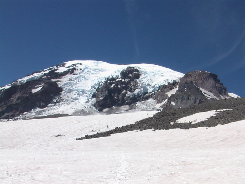
Here's a picture of the snow field. Camp Muir turns out to be around to the right, near the large rock that looks like it has a staircase on the right side.
Video on the snowfield:
Climbing the snow field was enormous fun. I just followed boot tracks when I could. The steps were closer together than was comfortable for me (no doubt they were made by people with heavy packs) but it was much less effort to follow them than to try to skip steps or kick my own steps (both of which I did at times). I would have gone a lot slower if I'd had to break my own trail. After a while I could get into a good rhythm and really enjoy it. Shasta seemed to have gotten me in good shape, and although perhaps I should have done these climbs in the other order this way I could really enjoy this one. There were quite a few people on the snowfield and at Camp Muir even on this Friday--I probably saw over 100. And a few hundred more on the trails below. One thing that was a big contrast between Shasta (and my earlier Sierra backpacking trip) was how many women there were, not just on the trails but on the snowfield and looking like they were going to make summit attempts. That was really nice to see.
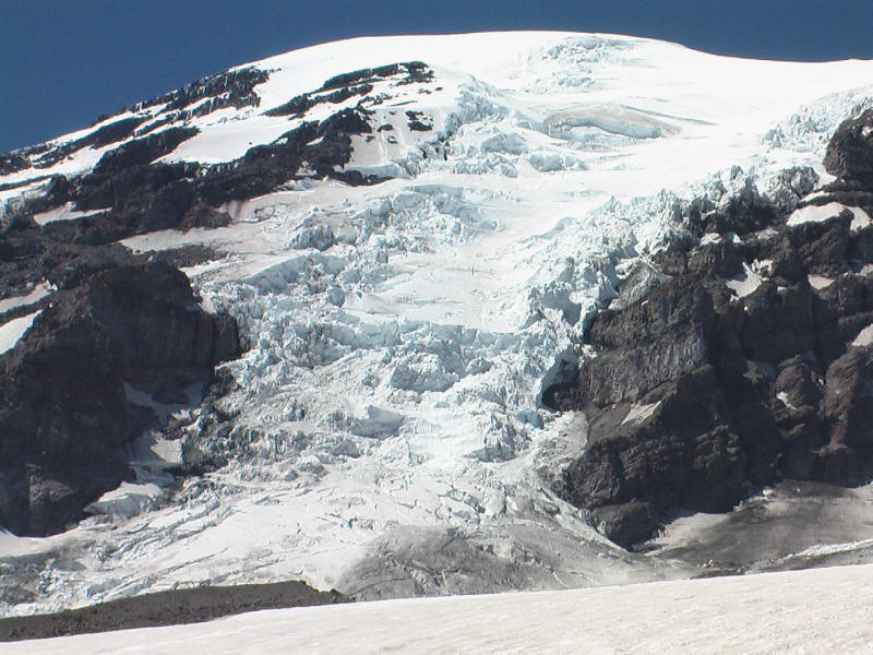
Time for more pictures. Here is a closeup of the Nisqually Glacier.
Continuing up the snowfield.
View to the south with Adams clearly visible, Hood dimly visible in the center, and Saint Helens further right and out of the frame.
I was feeling great and was passing everyone. Of course almost everyone else had a heavy pack, but still it was wonderful to feel strong and be going fast. Only one guy passed me the entire trip, on the descent, and he was another dayhiker who was a young guy in very good shape who went down the field faster than me. I did run into him again, but only because he'd stopped to help an older guy who had injured his foot. The young guy lent the older guy his trekking poles and was carrying his backpack for him.
I ran into a couple guys coming down with big packs, and asked them if they'd come from the summit. They said yes, but that they'd climbed to the top in one day, camped there, and then came down this day. That sounded really cool--I'd never heard of people camping on the summit before. The weather was so good that the summit conditions were about the same as Camp Muir, they said. They were really exhausted from the climb, though.
UPDATE (3/27/08): I recently received email from Matt Trafford, one of the two guys, who happened to find this web page! I think this is the first time someone I've casually mentioned in a trip report has found it and written to me. He sent some nice pictures including this one of his partner Dave Heffner and himself on the summit that morning.
After less than 2 hours from Pebble Creek, I arrived at Camp Muir at 10,188 feet. Here's a video of me approaching Camp Muir.
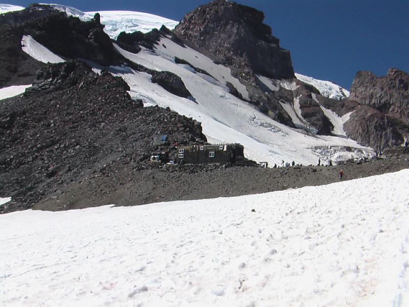
And here is a video from Camp Muir itself. The next few pictures are scenes also in the video. First the crowd at Camp Muir.
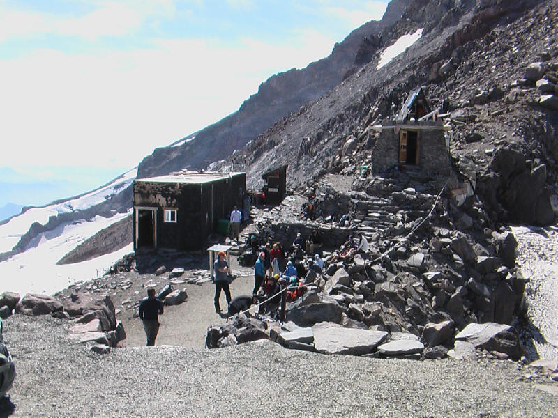
One of the tent areas.

A few people heading up toward the Ingram Glacier and the Disappointment Cleaver route.

Closeup of the rope teams. Notice also the rockfall.
Mount Adams from the summit.
The weather at Camp Muir was nice, around 50 or 55 degrees (I brought my pocket weather meter) and I think the wind only around 15mph, although it was a cold wind so I put on my rain jacket. I sat down near the outhouses (not smelly at all this day) and enjoyed the view, ate some food, and prepared for the descent, putting on rain pants for the glissades.
I then headed down. I didn't see anyone skiing this day, although I did see a couple guys going down the trail (when I was going up) with skis strapped to their packs. The snow was sun cupped and in really bad shape, so it was a bit of a pain to descend. Glissading, however, was great fun, a huge contrast from Shasta. In fact the problem here was that the slope was not steep enough! It was hard to get up any speed even in good-quality chutes. The snow was a bit soft, perhaps, and I think my ice ax, on the back of my pack, might have dug in a little and slowed me down. I just used the trekking poles when I glissaded, and indeed I needed them more to push myself and keep myself going rather than any worries about slowing down. It got quite tiring on my arms at times and I'd go back to walking down. I figured it was safe enough to take a video of my glissading, so take a look at that. One nice thing about going slow is that you can enjoy the beautiful scenery while glissading!
Thanks to the glissades I was able to get back to Pebble Creek in an hour, about half the time it took to go up. This was easily the most enjoyable descent I've had on any hike. Around the steep section I ran into something interesting--a girl was starting up the snow field wearing only a running outfit and running shoes! She was having a lot of trouble getting up the steep section and her partner had to help sort of haul her up. I only managed to get a picture after they passed.
I'm not sure how much farther they got--after all it was late in the day and a long way to go to Camp Muir. I guess the weather was warm enough for the running suit, but I'd be more worried about the footwear, as her feet could get quite wet and cold. I hope they didn't try to go too far.
I can't resist including one more shot of Adams.
At the bottom steep section is the only really steep glissade chute. You get going very fast but there's a soft landing. This was a lot of fun and a nice way to end the snow field.
After that it was back to the trail. I took off my rain pants right away but left the gaiters (which were really unnecessary as the snow didn't get deep) on for a while, thinking it didn't matter. But when I took them off I found it did feel a lot better--they restricted my foot movement and I think caused some pain I felt on the top right of my left foot after both Shasta and Rainier.
Near the top of the Skyline trail I had a very unexpected encounter. I ran into an animal that looked like a sort of cross between a billy goat and a horse. It was white and beautiful. It actually stopped for a bit and looked at me as I stopped to get out my camera, but bounded down the slope before I could get a picture. At the ranger station I asked and they said it was a mountain goat! The ranger told me it was rare to see them so I was happy I did, although sad I didn't get a picture.
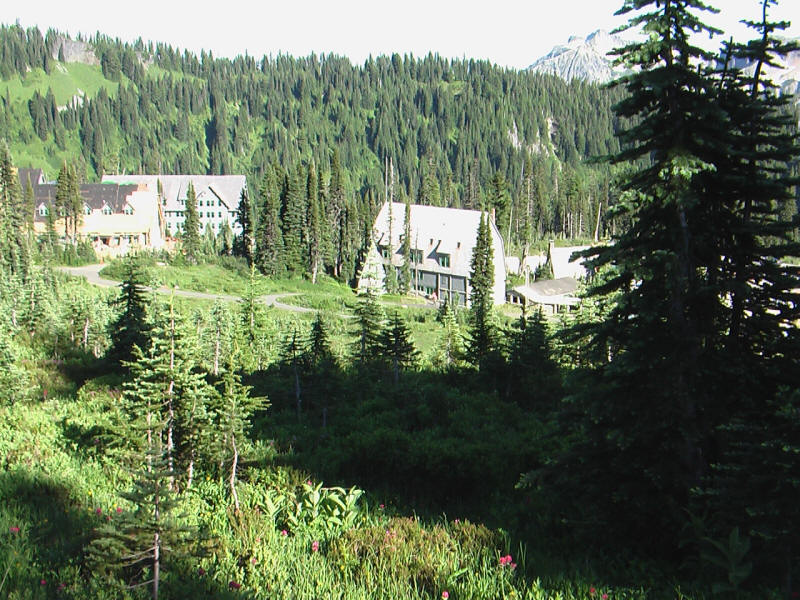
Here toward the bottom is a view of the new construction in the Paradise Inn area.
I made it back down to the visitor center a little after 6pm, so just over 5.5 hours total, and a half hour or more of that had been spent taking video and pictures. A surprisingly easy hike. I went to the car first but Kyoko and Kyle weren't there, so I took some time to get changed and get my gear stored. Then I tried to find them in the visitor center, but it was huge and I ended up exploring the whole center before I found them back on the ground floor--they'd been in the gift shop. Kyoko was surprised I got back so quickly. I wanted to buy a Rainier baseball cap but the only decent design was in red and I already have a red Yosemite cap, so I didn't get anything. It was good I got back when I did as they were closing everything down at 6:45pm. We got some ice cream for Kyle just before the grill closed and headed out, driving that night to Wilsonville, Oregon (just south of Portland) where we had dinner and stayed in a cheap motel. Then the next day we drove over 14 hours back to LA.
In 1999 I did my first serious hike, up Half Dome, which was good because it's an incredible hike (I've done it another half dozen times since then) but bad because I wasn't able to find anything else nearly as good as it! Now, finally, 8 years later I've found a hike that I'd rank up with Half Dome. The hike to Camp Muir has everything that makes Half Dome so great--nonstop incredible scenery, enormous variety, and just purely fun to do--but also manages to be completely different. It's also a lot easier, which is nice. I'll certainly do this hike again in the future and bring friends along. Kyoko and Kyle could do the hike with little problem, I believe. And now I want even more to complete the trip and reach the summit--maybe this will be even better than Half Dome? It's actually very good things worked out this way and I didn't end up climbing with a guide service. I would much rather learn the other skills I need (glacier travel and crevasse rescue) and do the climb with a friend or two rather than with guides. This way I can do the climb when I want, with people I know, and at our own speed.
The army guys I'd met on Shasta had done Rainier and said at my speed I could easily do the Disappointment Cleaver (DC) route in one day. At the time I was exhausted on Shasta, which has 7000 feet of elevation gain, and couldn't imagine doing Rainier, which has 9000 feet of gain and crevasse worries. But now, having actually been on Rainier, I think it should not be so bad, assuming I'm in good enough shape. After all most people do it in two days camping at Muir, and it had only taken 3 hours for me to hike to Muir, with maybe a half hour of that spent shooting video. Assuming one is in shape and acclimatized, why bother hauling camping gear up to Muir just to save 3 hours? Part of the reason must be to train for harder climbs where one does have to take multiple days, but I can do that later. It seems best to pick a day next summer with good weather, travel as light as possible, and do this climb as a long day hike. The route seems to be reasonably well-marked and there should be plenty of other teams climbing it at the same time. Now I just need to find someone to do it with me! Any volunteers?
Roundtrip distance: 9.2 miles
Elevation gain: 4788 feet (5400 to 10188)
Time up: 3:09 (12:27pm to 3:36pm)
Time on top: 0:25 (3:36pm to 4:01pm)
Time down: 2:04 (4:01pm to 6:05pm)
Total Time: 5:38
| Location | Time |
| Trailhead | 12:27 |
| 2.7 miles to Camp Muir / 0.8 miles to Pebble Creek |
1:12 |
| arrive Pebble Creek | 1:36 |
| cross Pebble Creek (after a snack break) |
1:46 |
| arrive Camp Muir | 3:36 |
| leave Camp Muir | 4:01 |
| cross Pebble Creek | 5:02 |
| 2.7 miles to Camp Muir / 0.8 miles to Pebble Creek |
5:21 |
| Trailhead | 6:05 |