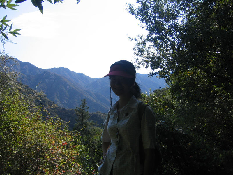
On July 23 I hiked with Lydia Yue in the San Gabriel Mountain Front Range. As she lives in El Monte, near Mount Wilson, I gave her a choice of three loop hikes starting at Chantry Flats: The Hoegees Camp loop (about 5 miles), the Mount Zion loop (about 9 miles) or the Mount Wilson loop (about 14 miles). She chose the first one and we had a very enjoyable hike. It was too short to write a separate trip report about, but here's a picture of her on the Upper Winter Creek Trail, I think.
I know Lydia from the Music of China group at UCLA, and later that summer, September 24, I hiked up Mount Baldy with Huan Wang, another friend from Music of China. Another member of our ensemble, Yongning Zhu, was also very interested in hiking. Unlike Lydia and Huan, she hadn't hiked in the mountains in China when she grew up, but she did her masters degree at the University of British Columbia and really enjoyed hiking in the mountains near Vancouver. She is a math PhD student like me, but as she's second year and I'm fifth and we have around 200 graduate students at UCLA I likely wouldn't have known her if it weren't for Music of China. She's gone hiking in the San Gabriels and elsewhere with other friends, but said she hadn't really gained much elevation when hiking here, and wanted to do more of that. So I thought it would be fun to try Mount Wilson, which I still wanted to try climbing, with her.
Mount Wilson, at 5710 feet, is the highest mountain in its vicinity, and has the distinction of having an observatory at the top, TV and radio antennas also clustered near the summit, and "can be climbed by trail from more directions than any other peak in Southern California" (Trails of the Angeles by John Robinson). I already knew from hiking with Lydia in the area that the biggest challenge would be simply to keep on the right trail as there are trails and use paths everywhere. However one thing I noticed this hike is that my ability has increased dramatically to read terrain and figure out where trails are and what is not a trail. That proved very useful and we didn't have many problems. Most trail junctions were well-marked as well.
I decided to roughly follow the "Mount Wilson Loop" in Afoot and Afield in Los Angeles County by Jerry Schad, which lists the distance as 13.8 miles (I originally told Yongning it was 12!). A ranger we met near the end of the hike told us it was actually 14.5 miles, which the signs (which typically had longer distances than listed on my Tom Harrison Mt. Wilson Trail Map) seemed to support. And we also we took a side trip to Sturtevant Falls, which according to the map added 0.6 miles. So I'll just say the trip was 14-15 miles for now. It certainly seemed a lot longer and harder than Santiago Peak, the last hike I'd done, which was supposedly a longer hike with more elevation gain (to be fair I was carrying a lot less weight, though). I do think it was not as hard as Mount Baldy, despite being longer and with nearly as much elevation gain. The main difference is that Baldy is both a lot steeper and also at much higher elevation.
I had a couple new "toys" for this hike, one being new mountaineering boots. I'd just bought new La Sportiva Trango S EVO GTX boots from REI (after trying them on months ago in Boulder, Colorado--they told me the Manhattan Beach REI had them in stock but when I went there they didn't have them, so since I knew the size I wanted I ordered online). I'd never hiked in anything more sturdy than trail running shoes before so this was a big jump, but I'd bought them with the hope that I can use them on Rainier next summer and in any case for more difficult mountaineering routes in California, Colorado, and elsewhere was well. I wore them home from REI Santa Monica, where I picked them up, as a first step toward breaking them in. They're not really meant for walking on asphalt, but were still comfortable even with cotton socks and the original insoles, and I only had some irritation on the tops of my big toes. This time I wore them with Superfeet I'd purchased at the same time (I was delighted to find the D green Superfeet fit perfectly into size 42 Trangos, so no trimming required) and proper liner and hiking socks. No trouble with the big toes but I did have some abrasion on my heels, especially the right one. I didn't bother to put on moleskin as it mostly only happened on steep upslopes. Although an easy first class mostly dirt trail is also not really what the boots were meant for, they also performed admirably and were very comfortable. In fact they weren't even too hot (unlike the original walk home from REI), and although it was a cool day I'm a little worried that maybe they won't be warm enough for Rainier...but we'll see. I carried my trail running shoes in the backpack in case I needed to change back into them, but the Trangos were fine the whole hike.
Also to train for Rainier I carried my larger 52 liter backpack (and have ordered a 70 liter pack which will hopefully be the one I use on Rainier) and put in more weight. I'd carried 22 pounds on Baldy when hiking with Huan and this time upped that to around 27 pounds including 7-8 liters of water (two 1 liter Nalgene bottles and 5-6 liters in two collapsible Platypus bottles). I was a bit worried about both upping the pack weight and trying new shoes, but it worked fine. The goal is to get to 40+ pounds and keep a good pace.
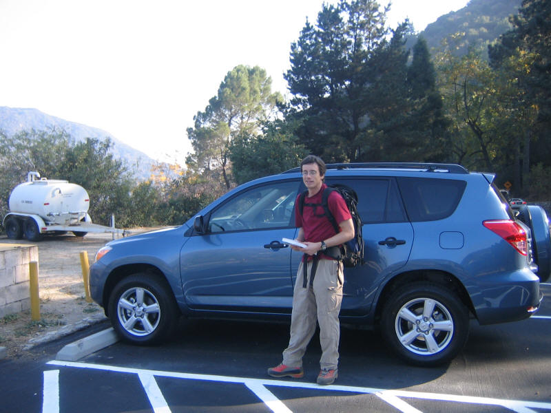
The other new toy was a new car, the second car I've ever owned. The first was a 1996 Honda Civic LX, purchased November 1995, and although it still runs fine and has less than 53,000 miles (since we've never used it to commute) I figured it was time for a new car. My wife and I both independently and simultaneously during the summer decided we wanted an SUV, her because she wants to sit higher and me so that I can drive to trailheads on bad dirt roads. After some research and trying things out we settled on getting a 2007 Toyota RAV4 Base V6. I also wanted 4WD, but was talked out of it by a dealer since there are so few for sale around here. I guess it's not really clear I need 4WD at this point so it doesn't make sense to pay for it. Later on if I do decide I need it I'll think about getting a new car (and I may also need more ground clearance than the RAV4 has, although it's a big improvement over the Civic). I just bought the car Friday night so Sunday for this hike was only the third time driving it, and the first really of any distance, and I must say I loved it. I'm really glad I got the V6--what a nice change to have enough power to get up to speed on the highway and to climb the mountain roads. For the first time after a hike I actually looked forward to the drive home.
I couldn't get Yongning to leave before 6am despite the promise that we'd get an extra hour of sleep due to DST ending, so I got up at 5am and picked her up a little after 6am. The drive to Chantry Flats via the 10, 5, 2, 134 and 210 freeways was quite fast, only 45 minutes or so. However I realized when we arrived that I'd forgotten my "Adventure Pass" (a parking pass for national forests in Southern California), leaving it in the Civic. There was a place that sold them at Chantry Flats, but it was not to open until 8am. However a guy was outside and said he could sell us a day pass. When I told him what happened he said I could buy a "second car pass" for $5, the same price as a day pass. So Yongning bought that and now she can use it until next August.
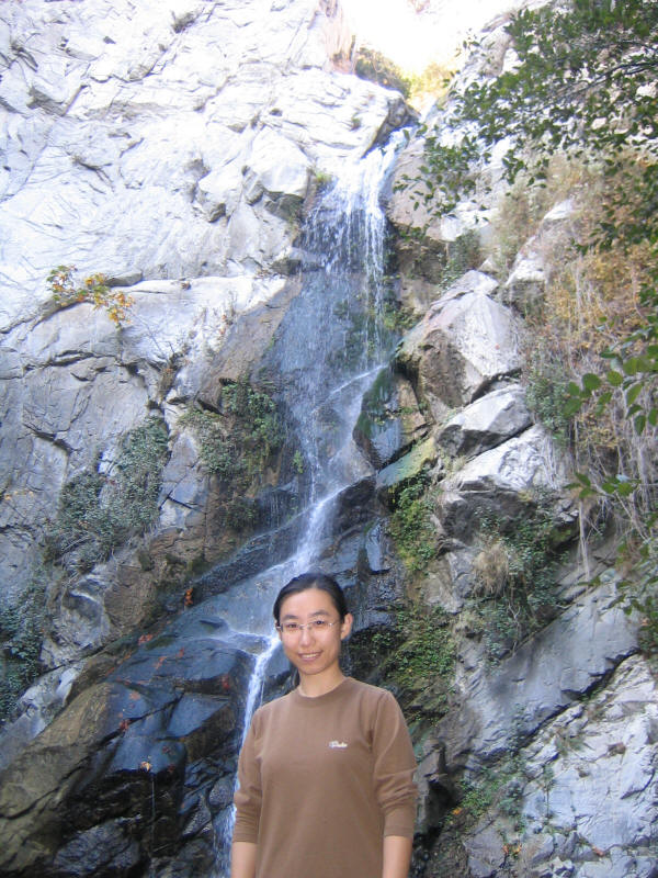
We started the hike finally at 7:08am, going down the road leading to the Gabrielino Trail. So almost immediately we diverged from the route Lydia and I had taken (the Lower Winter Creek Trail). We first headed up to Sturtevant Falls, where we took a picture.
My camera's battery warning was flashing so I didn't take any more pictures until the summit. We then continued to Spruce Grove at 3100 feet, where we stopped for some snacks at 8:50am. I'd brought just random things I scrounged the night before, including a mostly empty bag of Cheeze-It Crisps, an unopened package of dried raspberries that Kyoko had bought months ago but I hadn't tried because they didn't look good (they ended up being delicious!), two Handi-Snacks cheese-and-cracker packages (that my son brings to his kindergarten lunches), and a sort of Japanese powerbar type thing called BalanceUp (which I didn't like much). I just ate some chips and raspberries and saved the rest for lunch. Yongning brought some powerbars for snacks and a real sandwich for lunch.
We'd gone about 3.5 miles but had only climbed about 1000 feet, so the real climbing began after that. I had Yongning hike first as I usually do and she kept up a good pace. I even had to struggle a bit to keep up with her on the steeper sections with my pack, which was good since it forced me to go faster than I would have on my own. However as we neared the top she wore out and started going very slowly. Interestingly on the way down she again started out going fast but the last couple miles again slowed down considerably. I had a slight cold the few days before the hike and was worried that might slow me down, although I felt fine. Interestingly as I hiked along I felt better and better and by the end of the hike it felt like my cold was completely gone! Maybe hiking is a good way for me to keep from getting sick.
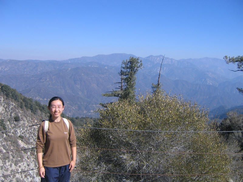
The hike itself was mostly in the trees, which was good and bad. The weather was perfect, and it stayed nice and cool the whole hike in the shade--just right for hiking. I didn't even need to put on sunblock the whole day, although I did get a little burned from the sunny sections. The trees were really nice, and included many you don't normally see around LA. We were high up enough that it was already "autumn", and the leaves of what were apparently sycamore trees had turned yellow and were falling, so that was very beautiful. On the down side being in the woods all the time meant you got very few views, and most of the time it didn't feel like I was on a mountain, but rather in some some kind of woods going uphill. Near the top we did start getting some nice views, and here is Yongning in front of one of them. As you can see it was fairly hazy. We were lucky in that the Santa Ana winds just died down that day so it was cool, but unlucky in that the haze and fog of course returned.
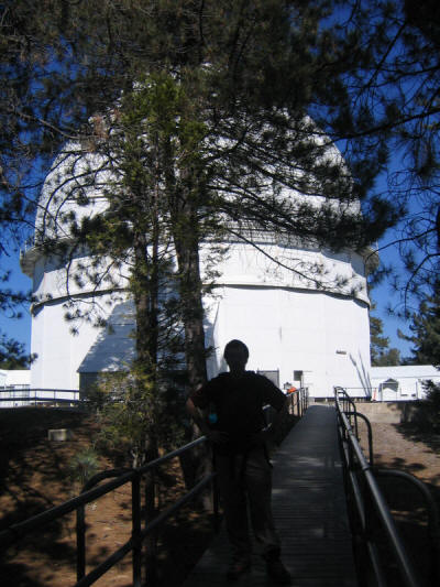
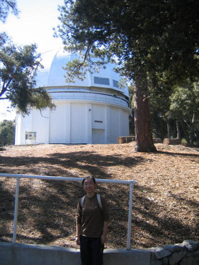
We made it to the top at 10:50, and walked around a bit looking at the buildings housing the telescopes. As there was no one else there at the time (we saw some other people shortly after) we couldn't get a picture together, but here is me in front of the 100 inch telescope and Yongning in front of a smaller one. Despite it being Sunday we saw very few people on the trail the whole day, and almost all of them were just a mile or two from the trailhead or at the summit (which can be reached by car!). So it was great to have most of the mountain to ourselves!
We neglected to try to enter the observatory (which was apparently open) but did explore a small museum which had some great pictures taken with the telescopes. We then headed down to the main parking area and continuation of the trail. I'd intended to have lunch at the picnic area or some spot with both shade and a view, but we must have missed the picnic area and there we no good spots we saw around the parking lot. So we just went down the trail a little, stopped and sat on some rocks, and ate our lunch there.
The hike down was easy and of course much faster than going up. We ran into a nice ranger on the way who was fixing up the trail bit by bit. The trail has eroded away in many spots and is quite slippery and even rather dangerous at times, so it's great they're working on it. The last section we hiked, the Upper Winter Creek Trail, was the same I descended with Lydia earlier in the summer, so it was nice to revisit that trail.
When I'm hiking or cycling long distances I often think of episodes of my favorite TV show Frasier, and for hiking I particularly often recall this scene from one of my favorite episodes (When a Man Loves Two Women), for some reason:
  Frasier: Anyway, what I wanted to say was that- [still worried]
           well, how long you been seeing this other fellow?
Cassandra: Not very long.  You're not upset, are you?
  Frasier: No, no, no, no.  Actually, I was about to say- well, uh,
           what does he do?
Cassandra: He owns his own venture capital firm.  Although he spends
           most of his time racing sail boats and rebuilding trails
           for the Sierra Club.
  Frasier: Oh really, seems a little unfocused, doesn't he?!

Frasier angrily reaches for a plastic stirrer, and like a madman
swirls his sugar into his coffee.  Cassandra picks up the signs.

Cassandra: You are upset, aren't you?
  Frasier: No, no, no, no.
Cassandra: Really, there's no reason to be jealous of Sloan!
  Frasier: [chuckling] Believe me, I am not jealous of Sloan!
           [licking his stirrer] If anything, I pity the man who has
           to go through life with a pretentious name like that!
Cassandra: Frasier!
Finally at 2:22pm we reached the end of the trail and walked down the road back to the parking lot. Here's a picture of me in front of my new car, and notice also my no-longer-pristine mountaineering boots.
After the hike the tradition is to eat Chinese food in the Monterey Park area. Yongning knew of some good places and decided on a Shanghainese place in Monterey Park, but it was closed until 5pm so we went across the street to Yungui Garden (the sign outside said something like Yunchang Garden, and the Chinese name is something like Yunnan Garden which was also apparently a former English name for it...). Yongning picked some excellent dishes which were all delicious, so we left very satisfied and drove home.
In summary this was a great hike on mostly high-quality trails that allow one to move quickly (plus it's not very steep save for a few short sections), with really pretty streams and trees to walk along. Still due to the lack of views for most of the hike I'd rank it below most of the other hikes I've done this summer. I must really be into views. I really enjoyed hiking with Yongning, and hope I can do so again. She's perhaps not quite as strong as Huan but is pretty close, so it would be fun for the three of us to hike together sometime.
Roundtrip distance: 14-15 miles
Elevation gain: 3600 feet
Time up: 3:42 (7:08am to 10:50am)
Time on top: 0:55 (10:50am to 11:45am)
Time down: 2:37 (11:45am to 2:22pm)
Total Time: 7:14