After the training hikes of Strawberry Peak, Mt. Baldy and Waterman Mountain, it was time to show Kaya Yuki my favorite of all hikes, Half Dome. I reserved two tent cabins for $39 per night each (very cheap weekdays before Memorial Day) and Kyoko, Kyle, Kaya and myself drove to Yosemite. We could have all stayed in a bigger tent cabin but it was actually cheaper to rent two smaller cabins. We left around 5am and got to Yosemite around 10am, driving up to Glacier Point, only the third time Kyoko and I have been there (I hiked up the Panorama Trail and she took the bus in 2000 (we walked down the Four Mile Trail together), and we drove there 2002), the second time for Kyle (with us when we drove), and the first for Kaya.
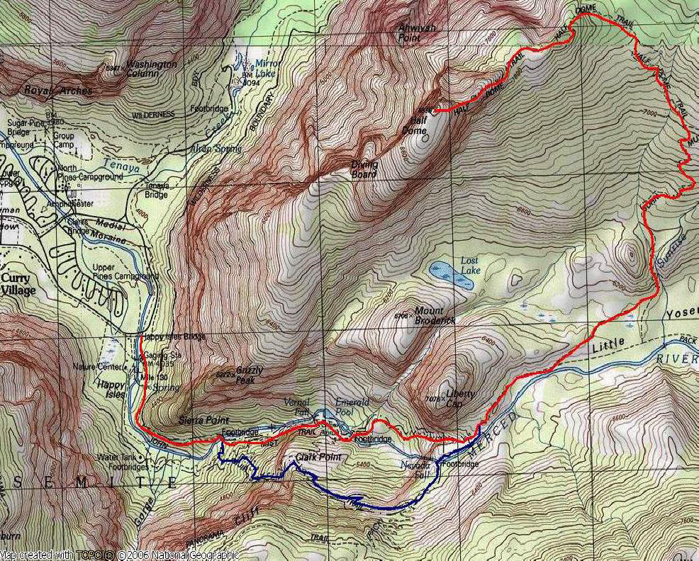
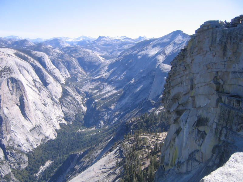
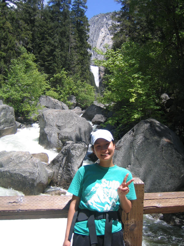
Here are Kaya and Kyle at Glacier point, with Half Dome, Vernal Falls and Nevada Falls in the background. The trail to Half Dome goes to the right of Vernal Fall, crosses the river, goes to the left of Nevada Falls then around the back of Liberty Cap, through the woods, and ascends Half Dome on the unseen backside. I've also climbed the visible Southwest Face via Snake Dike in 2004.
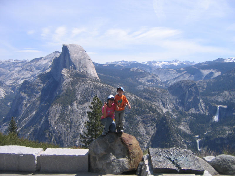
Another shot at Glacier Point.
We also hiked the Sentinel Dome. The usual hike is via a trailhead down the road from Glacier Point, but that looked full (Glacier Point itself was also swarming with people) so we tried a different trail from where we were. It was a little longer--I think 2.5 or 3 miles roundtrip compared to 2.2 from the normal trailhead, but still a short pleasant hike that I thought Kyle would enjoy. However he was in a bad mood--probably not enough food--and we didn't bother to really bring any food since it was such a short hike. He wanted to turn back several times but we kept him going. He also tends to not like basic hiking, but wants something more interesting like scrambling. So when we finally got to the dome itself he cheered up and was energetic. Unfortunately we didn't bring our camera and didn't get any pictures on the dome. Views were terrific, though, and this is now Kyle's high point (8122 feet) that he's hiked to. We then hiked down and got some ice cream at Glacier Point.
We drove to Curry Village, checked in, walked to Yosemite Village and Lower Yosemite Falls, took the shuttle from Yosemite Lodge to Curry Village, and had dinner at the buffet. Then early to bed since we'd get up at about 4:30 to get an early start on Half Dome. I didn't sleep well and kept waking up and checking my watch. Then I started dreaming that I was checking my watch, and it would show different times than when I checked it in reality. I ended up getting up at 4:18am before my watch alarm went off.
It took us a while to get going and we didn't leave until 5:10am. I brought my headlamp but we didn't need it from the start. Kaya used my lumbar pack and carried a half liter each of tea and water. I carried the rest (1.5 liters) of Kaya's tea in the original bottle, plus 3 liters of my own water. This was on the low side but I figured it would be a cool day and we'd be fine. Indeed we each drank about 2 liters or less, and Kaya never really drank the water. We brought snacks purchased at the Curry Village store--some energy bars, Clif Shots (which we didn't use), beef and cheese sticks, and candy. Kaya brought Skittles which she'd liked from our Strawberry Peak hike, and I brought gummy bears. For some reason the gummy bears tasted perfect on the hike. I didn't weigh my pack but would guess it was around the usual 22 pounds.
We walked the mile to the trailhead, and then stopped briefly for "breakfast", an energy bar each. I also ate my beef and saved the cheese for later. While we were stopped a group of four people passed us, but we soon repassed them on the way to the Vernal Falls footbridge. We saw one person with a large backpack a little later who seemed to be coming down from Little Yosemite, but otherwise we would not see another hiker again until just before the picnic area. Doing the hike early in the morning on a Monday before Memorial Day really paid off, and we had the incredible luxury of the trail going up almost entirely to ourselves.
We started at 5:44am. Kaya was still sleepy and not in a particularly good mood, but kept a good pace. She likes to keep walking without stops when going uphill (as do I) so I didn't take any pictures, figuring we could take them on the way down. When we reached Vernal Falls, it was flowing quite strongly, but there was surprisingly almost no breeze this early in the morning, so there wasn't much water being blown onto the Mist Trail. It was indeed just mist. I figured we didn't need to stop to put on rain jackets, so we just kept going and made good time to the top, arriving around 6:19am according to the time stamp on the pictures I took (so 35 minutes from the trailhead to the top of the falls, 1.5 miles gaining about 1200 feet). We then continued on to Nevada Falls, which was really flowing strongly and perhaps the most impressive waterfall we saw this trip. We took another quick picture here at 6:43am, an hour into the hike.

At the top of Nevada Falls we took off our top layers, which were wet (Kaya's cotton sweatshirt was soaked) and put on sunscreen, since it was getting warm and we were about to hit the sun. I put everything in my backpack and we continued on through the sandy "beach" section and then the gradual uphill through the forest. We reached the 2 mile marker (where the Half Dome Trail branches from the John Muir Trail) at about 8am. Kaya started to get tired and hungry, and I suggested we take a break at my usual spot, which I call the "picnic area". At some point I told her we were close, but then (as would be the case several times during the hike) it was further than I indicated.
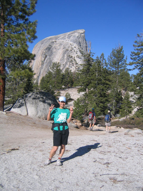
Here is Kaya pretending to be tired as we near the picnic area.
When we arrive a minute later (8:28am), though, she is already feeling better. Half Dome is in the background. We passed these two guys just before the picnic area, but then they repassed us when we stopped. We passed them again much later going down the Muir trail, and found out they'd started a half hour before us at 5:15am.
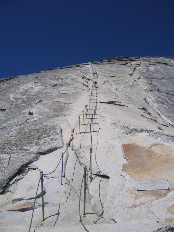
We stopped for a while, maybe 10 or 15 minutes, and ate some more food. Then it was time to head up the switchbacks to the saddle. I'd been worried Kaya would be scared of some parts of the hike, since she doesn't like narrow trails with exposure. However she said she was fine on the trails up the side of the two falls. The switchbacks, it turns out, she didn't like, although she didn't say anything at the time. Where she did finally protest, however, was the saddle, where she saw the cables for the first time. It's impossible to appreciate looking at photos just how intimidating the cables look in person. The two guys we saw at the picnic area were maybe halfway up at this time. Kaya nearly started to cry, and said she couldn't make it up the cables. They were too scary, and too hard, and so forth...I forget exactly what she said. She didn't sound completely serious when she said this, but then she never seems completely serious so I wasn't sure just how she felt. She told me afterwards that she wasn't in fact serious--she was just releasing her fear and stress that partly had built up from the switchbacks and partly from seeing the cables. She had in fact every intention of going up, but at the time I was worried she would bail and regret it later. So I encouraged her to give it a try, to concentrate on just moving from wooden step to step, to look only at the path and not down.
I'd brought gloves for both of us but they were cold-weather gloves and not optimal for the cables (plus I didn't want to tear them up). However there were plenty of gloves in the usual crack at the base of the cables. I found some decent ones for both of us. There's a sign now saying to pack out the gloves as they are trash, but there weren't a huge number there and I figured with the tourist season just starting there would be plenty of people needing them, so we returned them to the crack when we were done.
Kaya did a great job going up, and very soon I knew she was going to make it. We had the cables to ourselves save that one guy started coming down when we were near the top and we moved to one side to let him pass. I thought it was one of the two we'd seen and wondered where his partner was (especially mysterious as we at first saw no one else on top) but it turned out to be a solo hiker. He must have been the first up that day, so we were number four and five. We reached the top at about 9:28, so 3:44 to get up. I'd told Kaya my record was 3:30, and she was disappointed not to beat it. However I misremembered and my record was actually 2:55, so we were quite a bit slower than that pace. My second best was 3:45, though, and we just beat that.
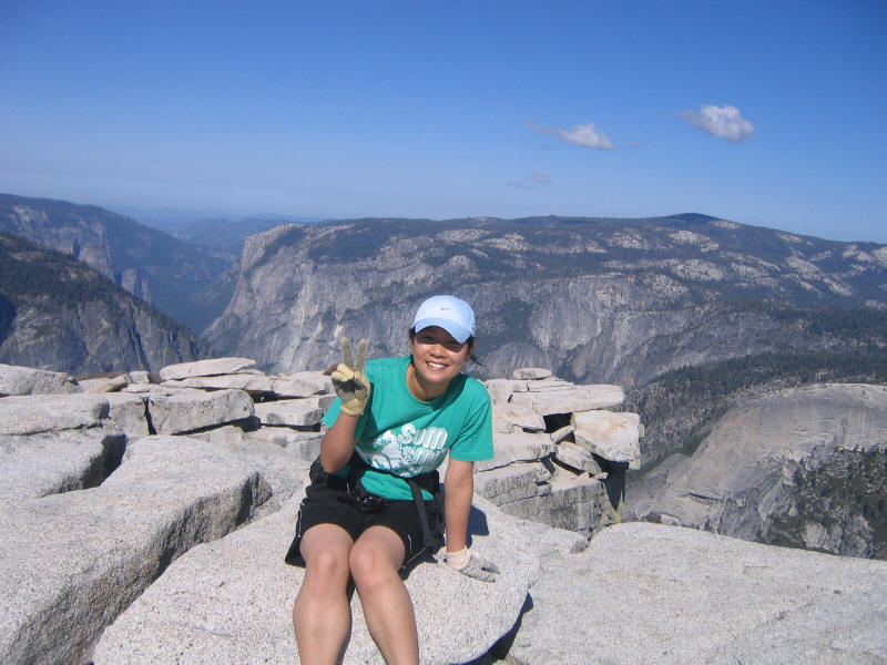
Here is Kaya on top. Note the mismatched gloves.
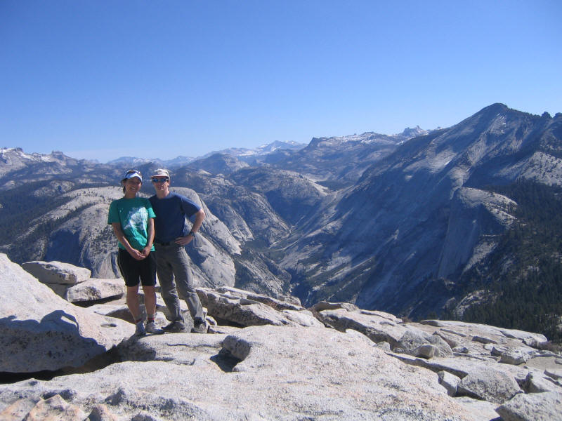
In a way it was lucky we were not alone on the summit, as we had someone to take pictures of us together! The two guys were hidden on the north side of the summit and it was a while before we realized they were there. Here is us on the summit, with a view toward the south.
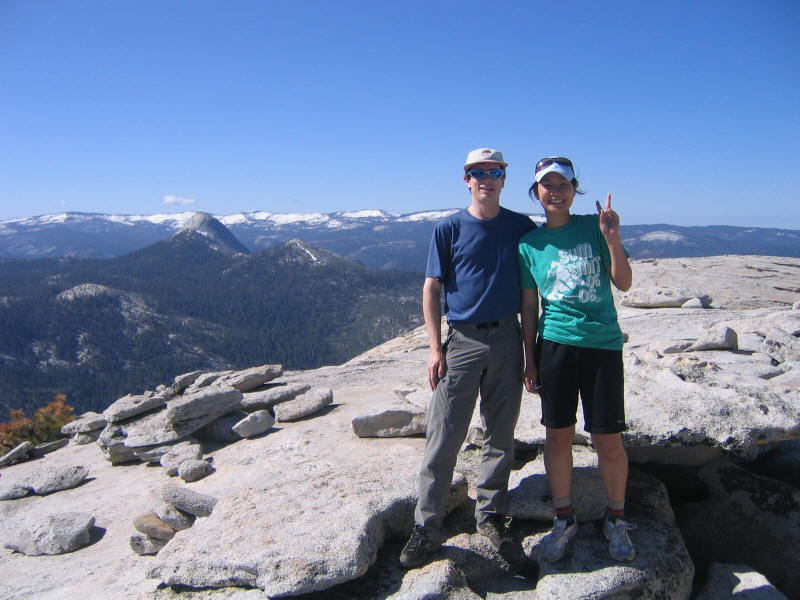
And a view toward the north.
The two guys left a bit before us so for a while we had the summit to ourselves, and even when they were there we didn't see them for the most part. Normally there are hundreds of people on the summit when I hike up so this was an incredible experience, certainly the highlight of the hike for me. Kaya on the other hand didn't realize how lucky she was! We ate a bit and explored a little, in particular walking and crawling out to the edge of the Visor (often mistakenly called the Diving Board, which is elsewhere on Half Dome). I don't believe I've ever been on the Visor, actually, since it is always crowded with people. We took a lot of pictures, but here is just one: Tenaya Canyon from the Visor.
Sometime after 10am (probably 10:05) we started to head down. I was even more worried about how Kaya would feel going down the cables. I normally like go down facing outward, a hand on each cable, and enjoy the incredible view and exposure while descending. Even though I'm scared of heights normally for some reason this doesn't frighten me at all. I wasn't sure how Kaya would react, though, and told her she could back down if she felt scared. To my great surprise, Kaya wasn't scared at all going down and faced outward as well. In fact she started to really enjoy herself, sliding down the rock at times and only stopping her slide at the next board. This frightened me a bit at first as I thought she might lose control. But she was fine, and when the slope lessened a bit I hurried ahead so I could take some pictures of her descending. Here is one of them.
I also took some video with my camera. We again had the cables all to ourselves, but when we reached the bottom there was a guy about to go up. Kaya thought the cables were a blast, and wanted to go down again even though she hated going up. In the spirit of her "Broken Friendship Hill" from the Mt. Baldy hike, she came up with names for the cables--two names this time, one for going up and one for going down. The former was the "Re-Broken Friendship Up Cables" and the latter was something like the "Not-Yet-Mended Friendship Down Cables". She wanted a helicopter to take her to the top so she could go down the cables, something like a ski lift it seemed. In fact helicopter rescues and helicopter trips to the summit were common themes in our conversation. This was part of her recent plan to live a wealthy "madame life" of ease and luxury. I feel it is my duty to save her from this terrible fate, and convince her that struggle and suffering are far more fulfilling.
At the top of Nevada Falls we decided to take the longer Muir trail down for variety. I should note that we started passing more and more people who were going up, and of course no longer had the trail to ourselves. The Muir trail is longer (8.2 to 8.5 miles depending on who you believe, compared to the Mist trail which is 7 miles) but is less steep and has different and also spectacular scenery so it was well worth taking. I hadn't gone down it since 2002, and had only taken it once before, I think, with Kyoko in 1999. (Well, maybe I also took it once or more on a solo hike.)
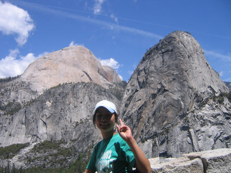
Here is Kaya on the Muir Trail, with Liberty Cap in the background.
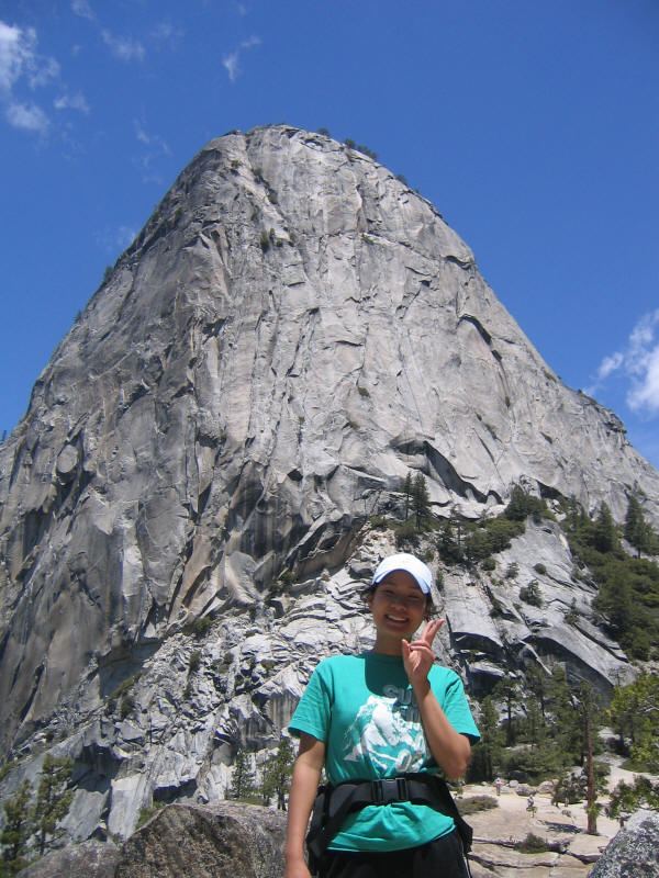
The south face of Half Dome, Mt. Broderick and Liberty Cap. You can just make out the saddle where the cables (around the corner and hidden from view from this angle) start.
High up on the Muir trail there's a lot of water dripping down onto the trail, and I always wondered where it came from. Kaya immediately suggested what must be the right answer--it must be snowmelt, and not everything directly flows into the streams of course. She tried drinking a little that was flowing down and thought it tasted good. She later tried the drinking fountain at the Vernal Falls footbridge and thought that was good too, both being better than my water from the restrooms (which should be the same water). Probably the only difference is that my water was warm by the time she tasted it.
Our feet started to get quite sore partway down the trail, the penalty for not doing another long hike before this one. Kaya started to slow down a lot, but we ran into a group of noisy middle-school students and Kaya suddenly sped up a lot to keep distance from them. We made good speed from there, although we did stop at the Vernal Falls footbridge near the end of the hike to take a quick picture.
We arrived back at the trailhead at 1:51pm, so 8:07 for the hike, a very respectable time and by far the fastest of any friend I've done the hike with. It was terrific fun for me, and despite the bad parts Kaya seemed to enjoy it as well. At first she said she'd never do it again, but not soon after she was trying to convince our friend Lydia to do it with us sometime. I told her later that the only bad thing about this hike is that she may never find another hike as good again. I certainly haven't.
At this point we were both tired and sore, though, and we limped into Happy Isles where we bought some overpriced ($3.25 or $3.50 including tax) hot dogs. They weren't anything special but tasted great at the time. Kaya at first wanted to take the shuttle back but after resting a bit felt good enough to walk, so we walked back and arrived at our tent cabins around 3pm. Kyoko and Kyle were back at this time and surprised to see us so early. They'd planned to do the Mist Trail perhaps but ended up just walking to Happy Isles and playing in the Merced River. They'd just gotten back so it's possible they were playing there while we ate our hot dogs! We had no idea they were there at the time.
Kaya and I showered and took short naps and then we all had pizza for dinner in Curry Village, ordering a large and actually managing to eat all of it. Then Kaya and I tried to work on some algebra but now it was my time to be very sleepy and we only did one problem. A very large group of high school students had checked in that afternoon on some kind of school trip and they were running around everywhere and making a lot of noise. However I was so tired I went to bed at 8pm and didn't wake until after 4am. Apparently they did quiet down at 10pm.
Distance: 15.5 miles (plus 2 miles roundtrip from Curry Village)
Elevation gain: 4800 feet
Time up: 3:44 (5:44am to 9:28am)
Time on top: 0:37 (9:28am to about 10:05am)
Time down: 3:46 (about 10:05am to 1:51pm)
Total Time: 8:07
Intermediate times are approximate (+/- 5 minutes)
| Location | Time |
| trailhead | 5:44am |
| top of Vernal Falls | 6:19 |
| 2 mile marker | 8:00 |
| picnic area | 8:28 |
| summit | 9:28 |
| leave summit | 10:05 |
| trailhead | 1:51pm |
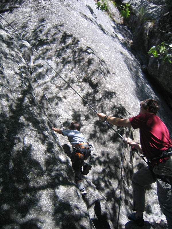
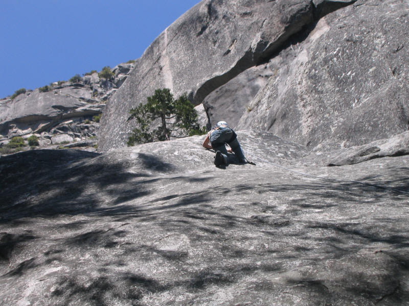
In the morning we got started late enough that the high school students, who were all talking about a bear they thought they'd heard the night before, were lined up for the breakfast buffet and we thought we'd have to eat at Yosemite Lodge. But it turns out they had a separate line for them and only let in about 10 at a time so we were able to get our own food without much trouble. We then drove to Camp 4 to climb at Swan Slab before driving home. I couldn't quite remember where the slab was and so ran ahead until I found it. By the time we got there (around 10am), there was a couple just about to start up the Oak Flake and a climbing class further to the right. Fortunately the section I wanted to do, the Unnamed Gully and friction climbs to the left of it, were free. The gully has a lot of sentimental value since it's Kyoko's first outdoor climb and my first lead, and I thought it would be a good first outdoor climb for Kaya and also one Kyle could make it up and enjoy.
We walked up to the left to set up a toprope anchor. I had Kaya carry my cams and Kyle the stoppers on his new harness, which I'd bought for him for Christmas but which he sadly still hadn't used yet. Here he is examining the stoppers.

I set up the toprope using a cordellete in a sliding X connected to the tree and two nuts in cracks, using another accessory cord to extend to the edge. This was my first toprope to set with no help and I think it worked very well. It was nice to have dynamic equalization so we could move it around easily for various climbs.
I climbed the Unnamed Gully (5.1) first to make sure there were no problems with the anchor, and then Kyle climbed. Here he is starting up.
And now negotiating the tree.
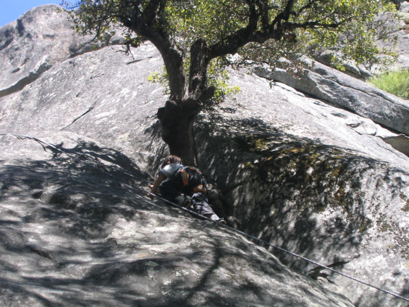
He did a great job and then climbed it two or three more times, getting better going up and being lowered each time. I climbed it a couple times as did Kaya. Here is Kaya at the tree.
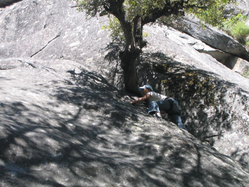
When Kyle used to climb he'd stop often to brush his hands together to get dirt off them, since he hates getting his hands dirty. This is not something one should do while climbing. He didn't seem to do it this time, however. On the other hand Kaya developed her own habit of stopping several time while climbing to pull the tail of her shirt down, since she didn't want us to see her panties, an effort which had only limited success. Inspired by Kaya's own naming schemes, and since this gully has previously been unnamed, I proposed the name "Kaya's Hidden Panties Gully", which I sincerely hope will be adopted.
After we got tired of the gully we tried some friction climbing. I had earlier tried something further left and found it hard to get started, so I suggested that Kaya try to climb nearer to the gully which seemed easier. It was only easier on the bottom, though, and then clearly got much harder. Still with some help from the rope and tension traverses she made it up.
It looked hard to me so I declined to try myself and just had her move the anchor left. I then made it up some kind of friction climb (the supertopo guide says they are between 5.6 and 5.8) and Kaya made it as well. We moved a little further left for a slightly easier variation. Kyle also tried but couldn't really get anywhere with normal shoes so I ended up pulling him up with the rope, which was a lot harder and more strenuous than actually climbing myself. He had a great time, though, as did all of us (except Kyoko who was suffering from allergies and declined to climb; she did take the pictures though). Kaya, as I hoped, really enjoyed her first time climbing outdoors and thought it was a lot more fun and interesting than the gym.
By around 2pm or so we'd climbed enough and headed home. We were still full from the big breakfast and didn't eat until a McDonalds at Gorman around 5pm or later. I was thinking we might just eat Japanese food in Sawtelle but Kaya and I both liked the symmetry of beginning (breakfast at McDonalds near Fresno on the way there) and ending the trip at McDonalds. The one in Gorman was nice but I'm glad I got my gas earlier ($3.40 versus $3.60 in Gorman). We got home around 7 or 7:30, I think. A fantastic trip!