As mentioned in the Strawberry Peak trip report, I planned to take a snow travel course on Saturday, May 5. However the class was cancelled (hopefully to be rescheduled soon). I was originally planning to do a shorter hike with Kaya Yuki (to continue our preparations for hiking up Half Dome on May 21) on Sunday, but with Saturday now free we decided to try the longer Mount Baldy loop on May 5. The hike is almost twice the length of Strawberry Peak and at much higher altitude (the trailhead at Manker Flats is at 6160, almost the same elevation as the top of Strawberry Peak at 6461!), but doesn't involve the rougher terrain and rock climbing of the latter. Mount Baldy seemed a good next step from Strawberry Peak, and the two are my favorite hikes near LA.
I'd already done this hike three times alone (in 2003, 2004 and 2006), and once with another friend Wang Huan last September, the last time I'd done the hike. I'd originally thought Huan would be a stronger hiker than Kaya, but after Strawberry Peak I realized Kaya was the stronger of the two. It had taken Huan and I 6.5 hours to do the hike (my fastest solo time, in 2006, was 4:46) and I figured Kaya could do it in 6 hours or maybe even less. We decided to leave early both to beat the afternoon heat and to have some of the rest of the day left, so the plan was for me to pick her up at 5am. Unfortunately due to drinking too much green tea and people partying in her building Kaya managed only to get 3.5 hours of sleep, and was almost going to cancel, but fortunately decided to try going anyway. I ended up picking her up around 5:15 but we got there quickly and arrived at 6:30; she managed to sleep a little in the car.
Nevertheless Kaya was still very tired and unhappy, and I was worried she was going to be miserable on the hike. We started at 6:39am and indeed she was very unhappy at the beginning, but I know from experience one always has good and bad times on a longer hike and I was hoping there would be some good moments to come. Just as on the Strawberry Peak hike I wore my mountaineering boots and medium-size pack. This time I made sure to bring plenty of water, over 6 liters. I also brought a lot of cold-weather gear including jackets, gloves, mitten, a wool cap and balaclava, both to add weight and bulk and more importantly from the weather forecast it seemed it could be cold and windy high up the mountain. My pack was over 25 pounds this time. Kaya carried her own things in my lumbar pack.
I'd somehow managed to cut my left foot a couple days before when trying on my new crampons (despite keeping the point protectors on), and although it was not serious and on the side of the foot, it somehow still hurt quite a bit when I walked. I was worried that would affect my hiking but aside from the pain I didn't have any problems.
From the Strawberry Peak experience Kaya had figured out that she likes to hike non-stop, with no breaks at all. So I let her set the pace and we started up. We did stop a few times, very briefly, once at the trail register near the start of the Baldy Bowl trail to sign in, at about 6:57am. It was chilly near the start of the hike and at some point Kaya wore my softshell jacket over her sweatshirt, but then took it off when we warmed up. We were down to tee shirts at one point but then had to put back on fleece and sweatshirt as we got a little higher and it got colder. I stopped to put on sunscreen when we got high enough that the mountain no longer blocked the rising sun. And I drank a little at the breaks as well, although Kaya would more typically just keep walking when we took a drink. Neither of us drank much this hike, a big change from Strawberry Peak. Of course the difference was the heat. We each drank only about a half-liter each for the whole hike, and I ended up carrying almost all the water weight the whole distance.
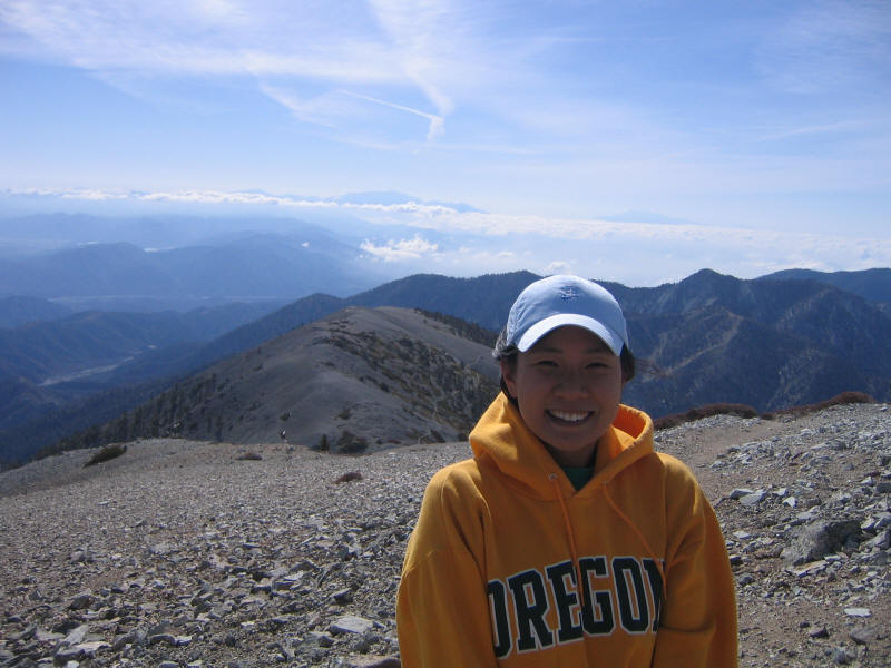
I honestly thought Kaya would stop a few times during the hike up, but she just kept going. Her pace was superb and mostly just right for me, although at times I had to struggle to keep up. Other times she would slow down and I could recover, but she still kept going. She didn't want to stop for photographs on the way up either, so I stopped briefly to take the picture below and then ran to catch up.
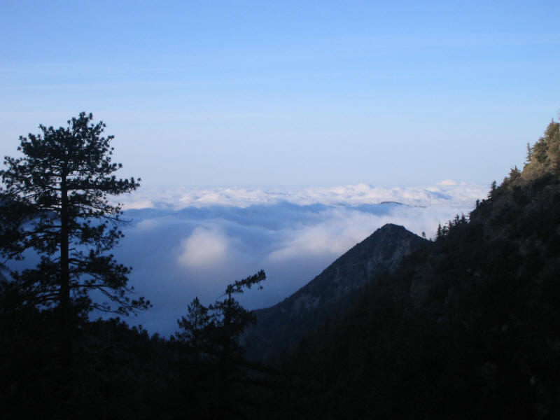
As the picture shows the LA basin was filled with fog. It never cleared up, in fact, so kind of sad that two hikes in a row we didn't get good views into LA, but on the other hand the clouds themselves were really cool to look at.
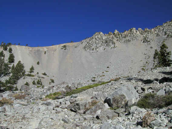
Kaya was both sleepy and tired, and mostly very quiet, which indicated she was unhappy. She didn't seem to enjoy the beginning of the hike at all, but cheered up a little bit when we reached a rocky section which she liked more. Her silence was typically only broken by sporadic shouts of "I hate hiking!" and "I hate John!". Nonetheless she continued her relentless pace. After the rocky section came steep switchbacks working up the left side of the Baldy Bowl. In the picture below, from my 2003 hike, the trail goes up the wooded section to the left of the picture. On the map at the top of this page it is the distinct switchback section around the middle left, just before the final ridge leading to the summit.
This was the low point of the hike for Kaya, and she named this section "Broken Friendship Hill". We should petition to put a sign up there and also get this name on maps. Nevertheless she had gone up the switchbacks without a pause and at a very impressive pace. We did stop to rest briefly at the top where we met two men with a boy who seemed about the same age as Kyle (6). They were debating whether to continue up or go down. They were the first of what would turn out to be many people we saw that day. The previous entry in the trail register was 6:25am, and that might have been them.
We continued up the ridge and the final switchbacks to the summit. Kaya was in a little better mood now and didn't find this section as bad as Broken Friendship Hill. I was curious how Kaya would react to the altitude, as this was likely the highest she'd ever been (she didn't remember just what mountains in China she'd climbed as a kid, but they were ones near Shanghai and for example the famous Yellow Mountains are all less than 6200 feet). She didn't seem affected by altitude at all, and surprisingly this time I was also unaffected.
It seemed we would make the summit by 9am, but Kaya slowed down a little near the top and we ended up summiting at 9:02, and so in 2:23. I knew this was fast but it wasn't until I got home and looked up my old times that I realized how impressive it was. My own fastest solo time was 2:28, so we'd beaten it by 5 minutes! It took me a full 3:50 to go up my first time, and Huan took 3:08. Kaya is an amazingly strong hiker already. And I was very happy with myself that I was able to beat my old time while wearing a much heavier pack and boots. I'm still progressing.
As we neared the summit the wind started picking up, and it got colder. Still it was sunny and didn't seem so bad. We saw some other people reach the summit via a trail from the west, but they immediately turned back. We would soon realize why. When we reached the summit there was an extremely strong cold wind, and the temperature seemed colder as well. It was strange because it still seemed warm in a way, but my hands seemed to freeze instantly. It was a very strange feeling and also a bit scary. I'd brought along my pocket weather meter and measured the temperature to be 28 F and wind chill 15 F. The actual temperatures were perhaps lower as I didn't really give the device time to settle. We measured the wind speed at times and got readings up to 34 mph; it was probably higher at times.
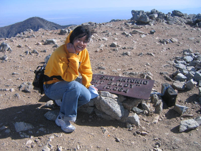
I wanted to get a picture of Kaya and me together on the summit but at the time there was no one else there (a woman did come up as we were leaving) so I took a quick picture of Kaya. I noticed the registry box for the first time (maybe it wasn't there on previous hikes) and made sure to sign this time, with the simple comment "windy!". We were the first to sign for that day, so the people we'd seen earlier must have not bothered.
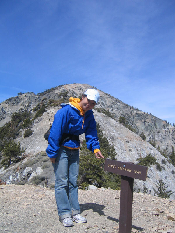
It was so cold and windy that we did this all very quickly, in 4 minutes or so, and then quickly headed toward the Devil's Backbone Trail. Here we are near the start of that section, which has my favorite scenery of the hike. You can see San Gorgonio and San Jacinto in the distance sticking out of the sea of clouds.
The cold and wind didn't subside, and we decided we'd better bundle up. We wore my two rain jackets, which were excellent as windbreakers, and Kaya wore my gloves (purchased in Yosemite for Whitney) and I my new mittens. I wore my balaclava and Kaya just used the hood of her sweatshirt instead of my wool cap. So we'd used just about every item of clothing I'd brought and it worked wonderfully. My hands still felt cold in the mittens at first but eventually warmed up and they felt great. In a way it was more fun to have harsh weather on the top of the mountain--it felt more like a real mountain this way.
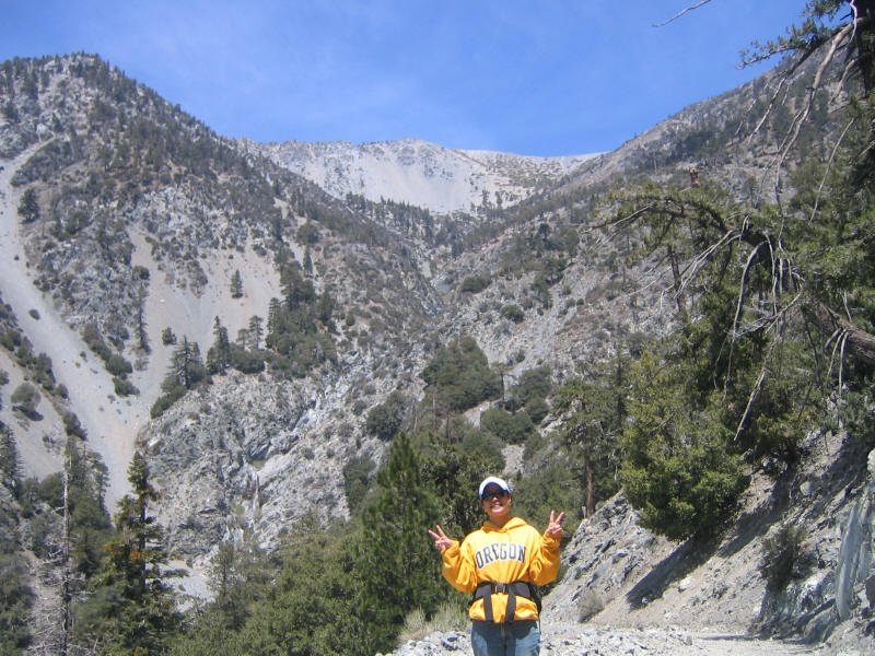
Kaya like me is slower going down than up, and we took our time descending. We started passing many people heading up, as the usual and easier way to go up is the Devil's Backbone Trail. We warned them about the cold and wind, but wondered if conditions would improve as the day went on. Certainly as we got lower it became warmer and less windy, and the people hiking up probably wondered what we were doing bundled up. Eventually we took off the gloves and hats, and by the end of the Devil's Backbone Trail it was more pleasant. Here's a picture looking back toward the summit.
I didn't take any pictures along the backbone, but the scenery was interesting in that the view toward LA was still hidden in fog and low clouds while the view toward the desert was mostly clear. We reached the edge of the ski area and dirt roads to walk on. This is my least favorite part as some of the roads are extremely steep and slippery to get down. I was wondering how vehicles could ever get up them. But interestingly this time, the first time of the five I've done this hike, we managed to bypass all of the steep sections! Kaya, whose route finding skills seem already to surpass mine, suggesting taking a flatter fork of the road rather than going straight down the steep way. I'm not sure why I never tried this myself before--maybe I thought the road went the wrong way. But this was the best way to go down--although it was longer than the steep bypassing it was enormously more pleasant. I'll certainly do this in the future and now the hike has no real parts I dislike.
We finally reached the ski center at Baldy Notch which was open serving food, and the ski lifts were operating as well. Of course the ski season was over and there was no snow at all left on the mountain save for some small tenacious patches, but the lifts operate on weekends still to save lazy hikers some time and energy. We used the restrooms, which with flush toilets, real sinks and soap seemed an incredible luxury in the middle of a hike. We also stopped to eat some food, finally, at a picnic table outside. Kaya had a Luna Bar, I opted for a bag of Cheetos, and we both shared a little candy. This was all we ate during the hike save for a couple pieces of delicious Oregon berry pate candy that Kaya brought along. It was just enough for the hike, but we were hungry and ready for lunch by the end. At the ski center there were many people preparing for their hike up the mountain, including a large group with huge backpacks who were apparently starting a backpacking trip.
The walk down the fire road was uneventful. Here's a picture of Baldy Bowl with Broken Friendship Hill hidden by the ridge in the left foreground.
To complement the fastest time up, our time down (including stopping at Baldy Notch) was the slowest ever, at 3:19. But overall the 5:46 time was very good. Kaya was still very sleepy and although we were going to stop in Claremont to look around (since she'd never seen the Claremont colleges--she'd been accepted to Claremont Graduate School for a masters in math but decided to go to San Diego State instead) but she ended up sleeping the whole time I drove through Claremont. I drove right to the usual Chinese mall in San Gabriel, where we decided to try a new restaurant this time. At first we thought of the big dim sum place but it seemed the wait was long, so we tried out another place called Paradise Cafe, I think, which was crowded but still had a free table. It also turned out to be Cantonese style, and very inexpensive. It was not quite up to the two Shanghainese places in my opinion but still the food was great. You can see the San Gabriel mountains well from the mall, of course, and it seemed one mountain we could clearly make out was Strawberry Peak, which we had just climbed the previous week, so that was cool.
We then drove to Alhambra to visit a Chinese musical instrument store Lydia Yue had told us about. However when we got to the address Kaya had written down it seemed the store was not there, and a woman we asked in the same building seemed to know nothing about it. As we didn't have a phone number nor anyone we could call to help us out, we just gave up and will try again some other time.
We made it back home around 3:30, I think, rested up a bit (Kaya took a nap) and then met again at UCLA with a couple of Kaya's friends to see the Chinese Cultural Dance Club (which our friends Shelly Chang is a dancer and choreographer in) perform in Royce Hall. So a terrific day. I had a fantastic time hiking with Kaya and I hope she enjoyed it a little too and that we'll be friends again some day.... Depending on how she feels we may do one more hike next weekend (my vote would be for San Jacinto Peak via the Devil's Slide Trail) and in any case I'm looking forward to Half Dome.
Distance up: 5.1 miles
Distance down: 6.8 miles
Total distance: 11.9 miles
Elevation gain: 3904 feet
Time up: 2:23 (6:39am to 9:02am)
Time on top: 0:04 (9:02am to 9:06am)
Time down: 3:19 (9:06am to 12:25pm)
Total Time: 5:46