In Trails of the Angels, John Robinson writes "8007' Iron Mountain is by far the least accessible peak in the San Gabriels." Having done the "big three" near LA of Baldy, Jacinto and Gorgonio multiple times, Iron Mountain (or Iron Mountain #1 if you need to be more specific) seemed like the next most interesting peak to climb and was one I've wanted to try for a long time. Now that I'm moving back to the Bay Area it became especially urgent to do it this summer. When Jim Ralston solicited suggestions for a last math department hike of the school year I jokingly requested Iron Mountain. Of course Jim did not approve it, instead selecting a Mount Wilson loop I'd already done that was cancelled due to a threat of thunderstorms. However he was willing to separately hike Iron Mountain with me. He invited a few other people who might be up for a difficult hike and Ernie Esser agreed to join us.
The hike is described as 14 miles roundtrip (I'm not sure if that's from the parking lot or the Heaton Flat trailhead) with 6000 feet of elevation gain, which seemed quite reasonable. One worry was that only the first 2500 feet of gain was supposed to be on a trail, and "the last 3500' up a trailless, chaparral-and-forest-covered ridge." My main worry however was heat, and I figured the entire hike would have no shade whatsoever, so it could be quite unpleasant on a hot day. I can usually handle heat fairly well but I've had some bad times too. It turned out the day we planned to do the hike was in the middle of a heat wave, with temperatures topping 100 degrees in the valleys and I expected about the same along the hike. Of course we were not ones to be deterred by hot weather, but I did want to minimize our suffering. I would have been happy to start the hike at midnight or 1am and do the entire climb in the cool of night, but Jim and Ernie are not so interested in alpine starts. We originally planned to leave Westwood at 6am but I managed to convince them to make it 5am to give us an extra hour of cooler weather.
Jim had done the hike twice before, in 1980 and 1989, taking 9 and 10 hours respectively. He said that linear extrapolation would indicate the hike taking 12 hours this time, but I was optimistic we could beat his first time. Jim said to bring enough water, and that 3 liters was right for him. He'd run out of water the last time he did the hike, but that was because he'd had to lend out a lot of his own water. Three liters sounded about right to me as well, given that this hike should be a little more difficult than Half Dome, which is normally a 3 liter hike in hot weather for me. However I wanted to practice carrying weight for our upcoming backpacking trip, which this was a conditioning hike for (Taboose Pass should be quite similar, gaining 6000 feet in 8 miles in hot, unshaded desert conditions, but have the additional difficulty of being at higher altitude), and so decided to bring my usual 6 liters. I brought 1 liter of gatorade and 5 of water, freezing 3 liters of the water and refrigerating the rest before leaving. I figured this would be way more water than we'd need, and I could lend some to Ernie or Jim if they ran out, and not worry about drinking as much as I'd like. I used the same backpack I plan to use for the Sierra trip, and brought random other things including fleece and a light raincoat (in case we needed to bivouac!), my GPS (in case we got lost on the ridge), my weather meter (to verify just how hot it was) and new camera. I brought a few snacks but not a whole lot, having run out of a lot of my usual hiking food.
I offered to drive but Jim said he would; however he indicated he might want me to drive back. Everyone was picked up by 5:10 or so and we made it to the trailhead a little over an hour later. It was amazing how many people were parked around the San Gabriel River, fishing and camping there, especially on such a hot weekend. I guess you could jump in the river and cool off at least. There was no potable water at the campsites and you also had to carry everything quite a distance from where you parked your car, which made the popularity of the area this weekend even more remarkable.
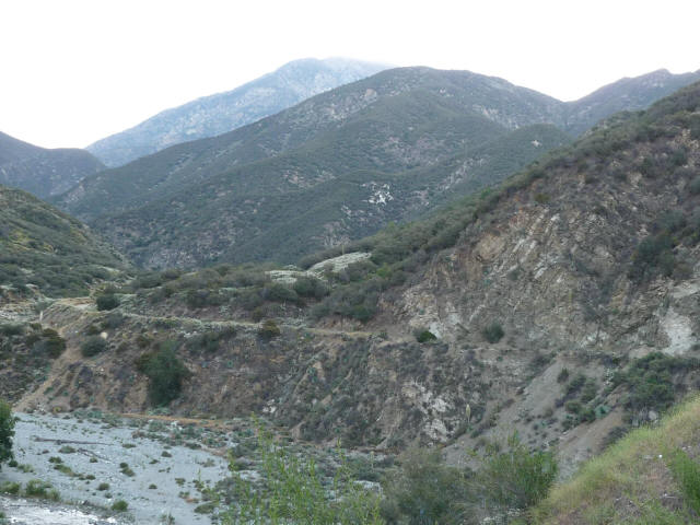
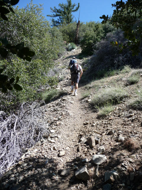
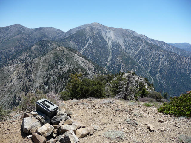
We started out at 6:34pm. The picture below shows the scene from the trailhead; we guessed the furthest mountain we could see was Iron Mountain.
We reached the start of the Heaton Flat Trail, a half mile from the original trailhead, at 6:42am. There were a few campsites here. Early on the temperature was pretty mild; I think my thermometer registered 85 degrees or so. It was useful to have it as we found it difficult to really judge the temperature by feel; due to low humidity perhaps it didn't feel as hot as it really was. Starting early we had the advantage, which I had counted on, of the mountains blocking the sun while it was low in the sky, so it was fairly comfortable at the beginning. Still it was warm enough that I drank my liter of gatorade within the first hour, despite the fact that the temperatures were the coolest of the day. I drink gatorade faster than water, but this still should have been a warning that this would be no ordinary day.
We had no worries about water, though. Jim brought 4 liters, I had my 6, and it turns out Ernie had brought 7 liters! With 17 between us, we felt ridiculously overprepared. I felt free to drink as much as I wanted, and I knew we would have plenty left at the end. None of us realized just what toll the heat would take that day. As I expected there was no one else on the trail that day (well we did run into a group at the very end of the hike close to the Heaton Flat trailhead); no one else would be stupid enough to do this hike in 100 degree heat!
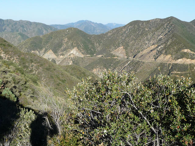
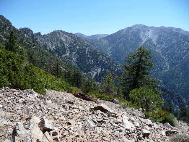
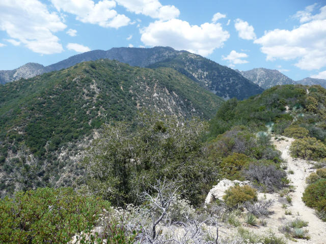
Here's some scenery from early in the hike; the picture below taken at 7:12am.
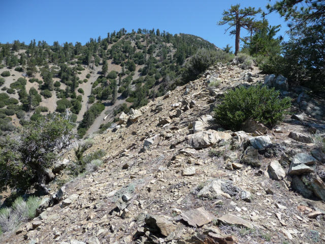
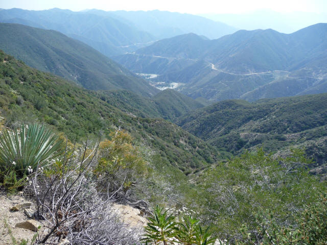
The picture below was taken at 8:34am.
I set the pace for the hike; I thought Ernie might want to go faster but he said my pace was fine and he usually hung back a bit. He'd stop often to drink a little whereas I would stop less often but drink more. Every now and then we'd take a short break and eat some food. As usual the other two had better food than I had, and I ended up mooching a lot of food. Ernie was particularly amazing. It seemed that at every stop he'd pull out a different container of food, and each container was quite large. I couldn't believe he could fit that much, plus the 7 liters of water, into his small backpack. I recall dried apricots, oranges, grapes, almonds, carrots, and I think one or two other things.
The trail was fine but I was starting to dread the trailless ridge. Particularly toward the end the trail was getting quite a bit overgrown, so I was imagining a lot of painful bushwhacking up the ridge. We finally reached the Heaton Saddle at 8:42am, so 2:08 from the start and exactly two hours to do 3.9 miles with over 2600 feet elevation gain. We were making fine time.
I was relieved to find the ridge to be not exactly trailless. In fact there was a perfectly good trail all the way to the summit, as good or better than the trail we'd already been on, the only difference being that some sections were extremely steep and slippery. I asked Jim if this trail was new, but he said it was just the same back in 1980. I think Robinson needs to update his book.
The ridge may have a fine trail up it, but it is very steep. It gains the 3500 feet in something like 2.5 miles, so 1400 feet per mile, which already should be the steepest hike I've done, but it's actually even steeper because you're going up and down quite a bit. You apparently gain 2000 feet in the last mile (see here). To be sure a tough hike, although not as bad as I feared due to the trail. Although the hike is advertised as 6000 feet elevation gain, that's net, and there seemed to be enough intermediate climbing to add an extra 1000 feet. Actually according to the Sierra Club site there is an extra 600 feet of climbing one way, which translates to 1200 feet total, and so 7200 feet of elevation gain overall.
There were parts of the trail which were so steep and loose that they seemed just on the limit of what someone could actually climb. What's more the chaparral made things miserable in parts, especially the yuccas. Some of them were trimmed, but there were still plenty to be avoided. I managed to get stabbed twice. One I ran straight into and it poked me in the left forearm. The second one was worse in that the tip broke off and embedded itself in my left forefinger, a painful souvenir of the hike. It still hurts quite a bit. I'm not sure how to get it out, but Jim said it will come out eventually. I was actually stung by a bee a few weeks ago (either in the same finger or the middle finger) and that stinger seems to be gone by now so hopefully this one will be forced out eventually.
The trail was so steep and loose in parts that it required all one's effort and attention just to get get up. Having yucca plants right in one's way on top of this seemed needlessly cruel. I was even more worried about the descent--losing control and sliding down right into one. However I luckily managed to avoid getting pricked on the way down.
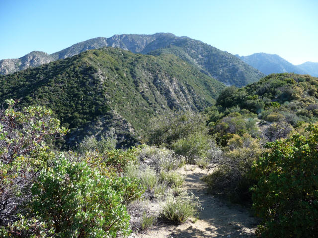
At 9:59am we reached a strange sign that said "W17"; I have no idea what that means. Sometime after that I let Jim and Ernie set the pace for a while and here's a picture (10:15am) of a relatively gentle section of the "trailless ridge".
I soon went back to the front. Here's a picture (10:36am) of West Baldy with Mount Baldy behind it and San Antonio Ridge to the left.
Finally at 11:01am the summit (or maybe this was just in front of the summit and blocking it) comes into view.
I made it to the top at 11:29am, so 4:55 to get up. Here's Ernie coming up right after. Jim made it up some 10 minutes later.
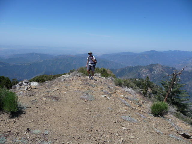
Below is a shot of the San Antonio Ridge and Mt. Baldy with the summit register in the foreground. I signed it with the first thing that came to mind: "Piece of cake!" Indeed the climb was a lot easier than I thought it would be. The most recent entry was exactly a week earlier (6/14), by some guys who made it up in 5 hours with 30 pound packs (I guess mine was 22-25 pounds, at least at the start). One earlier entry said they made it up in 4:02, which seems doable with a lighter pack and milder weather. Anyway I was quite happy with our time, and it seemed we could finish up in 9 hours or less. Some people seemed to be continuing on to Baldy via the San Antonio Ridge, and some of them doing the trip as a 2 day backpacking trip. This seems a popular option (Schad even describes it in his book) which is more difficult than the hike we did. There's a list of difficult day hikes in the San Gabriels, most of which involve Iron Mountain and/or Baldy, and Baldy via Iron Mountain and the ridge ranks number 3 whereas this hike is number 5.
We stayed on the top, eating and enjoying the fantastic panoramic view, until about 12 noon. We then headed down, and now I wanted Jim and Ernie to go first since I am terribly slow at descending. Jim tended to go fairly fast, but ended up slipping and falling on his butt quite a few times. I would go extremely slow, trying to stay in balance the whole time, which is not the best way to descend but I don't feel comfortable getting out of control. Still I managed to land on my butt four times, all soft landings fortunately. Ernie would leave a big gap, then run down out of control and somehow get back into control again in time. I wish I could do that but it may never happen, especially since I'm unwilling to practice.
For the steepest sections there was really no good way to go down, as I feared. I found in places that crouching on my left foot and holding the right one out as a sort of rudder worked; for others I crouched on both feet and sort of slid down. Anyway it wasn't quite as bad as I feared. What I did fear was the weather. Whereas our elevation gain had been enough to counteract the rising temperatures, and it was comfortably in the 80s (I seem to recall) at the summit, we were now descending into hotter temperatures which would only increase with both time and elevation loss.
I think we reached the W17 sign at 1pm, so an hour to descend to the point that took 1.5 hours to climb from. However at some point Jim slowed down considerably. He didn't seem to be walking very steadily either. We feared he wasn't drinking enough and as we still had plenty of water gave him more. A little later it seemed he was okay and just going slow so he said we should go ahead and he'd go at his own pace. I was getting worn down myself at the slow pace and the sun was getting to me too, so I went ahead and Ernie followed. I was getting worried about becoming severely sunburned as well, as the sun was relentless and I was sweating so much that my sunblock (I'd applied a second layer on the summit) was probably being washed off, and there seemed no way to put more on. I did get sunburned, but luckily it wasn't too terrible.
At some point I myself felt a sudden bout of severe lethargy--I felt it must be heat related and could understand how Jim felt. I had been drinking very freely and was well hydrated, though, and this feeling went away soon, probably after drinking a little more. After a half hour or so Ernie thought we should wait for Jim. Jim seemed to be going about half our pace but seemed okay; he's always so strong that I had no worries about him. But now when I thought back to seeing him I started to worry that something really was the matter. I let Ernie pick a spot to stop and he found one that while far from ideal seemed like it was the best we were going to get. There were basically two little spots in the chaparral that you could sit down in and get a little shade. There was also a bit of a breeze there. Surprisingly it was bearable to wait there. There were a lot of bugs flying around (as there were throughout the hike) but no mosquitoes at least, although I did feel like I was bitten once (maybe my imagination) and Ernie said he got a few bites. I tried to put on more sunblock but don't think I really succeeded. I should note that the temperature was in the high 90s and low 100s on the way down. I measured it at several points and the highest measurement was 102 in the shade. I'm sure there were even hotter portions, and it was quite a bit hotter in the sun of course.
At a couple points we noticed a helicopter hovering overhead as well. We wondered if someone had seen us start off on the hike and alerted the authorities that they'd better check up on us. Certainly we didn't want to have to rely on a helicopter rescue, though.
I thought it would take Jim 20 to 30 minutes to reach us. When 30 minutes passed I started to get worried and headed back to find him, but fortunately he was just a minute or so away. He was very happy to see us, having run out of water again and was in even worse shape. He rested in the semi-shade for a while, drank more water, and felt a little better.
We stayed together from this point on. It was clear we were in serious trouble. Jim was in the worst shape, but we were still far from the trailhead, and now despite supposedly having a huge surplus of water we were actually in danger of running out. I had drunk nearly 5 liters of my 6, and Ernie only had 1 or 2 liters left after already haven given Jim, who had run out earlier, a liter of his store. Jim still wanted to ration the water it seemed but we tried to get him to drink more. The good news is that I at least was fully hydrated and it seemed I could go a while with no more water; Ernie seemed thirstier though. We still had a long way to go through increasingly hotter temperatures, and I really felt we needed to get down as quickly as possible. But Jim was in very poor condition, panting hard even when he wasn't moving, and needed to stop every 10 minutes or so to lie down and rest for a few minutes in whatever shade he could find. Serious trouble indeed.
Jim thought he was suffering from heat exhaustion, and it certainly looked like it. However things somehow just barely worked out. Jim did start to recover a little and was able to walk a little better and take fewer breaks. We got a little cloud cover, as the picture (2:30pm) shows, although the sun was mostly uncovered. There was shade in parts were we had steep rock walls to our west, as the sun started sinking a bit (this was the longest day of the year, of course, not a good thing for us!). Little by little we were making it down.
A picture taken at 3:47pm shows the San Gabriel riverbed, our destination, still a long way away.
There were a couple creek crossings near the end but mostly the creek was dry; there was one point with some water but it wasn't much better than pond scum. Jim wanted to drink from that but we still had some water left so we made him drink ours instead. We did manage to make it to the end of the Heaton Flat trail with the tiniest bit of water left. I'm not exactly sure when we reached the trailhead. I took a picture at 4:36pm which was probably meant as some kind of timestamp, but it doesn't seem to be the trailhead. I think we probably got back to the Heaton Flat trailhead a little after 5pm, which although we still had a half mile to go was essentially the end of the hike for us. So something like 10.5 hours.
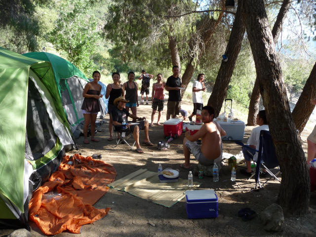
We went to the nearest campsite and asked if there was there were any pipes with potable water, but they said there were none. We were just going to drink out of the river, but the campers thought that wouldn't be safe (and they were no doubt right, as there were plenty of people playing in the water) and offered us bottled water. We tried to refuse but they insisted saying they had plenty, and gave us each a half-liter bottle. I talked with them briefly, asking if they were students. They said no, so they must be recent graduates. None from UCLA, but there were some from USC, UCI, and UC Davis. A very nice group, and before we left I asked if I could take their picture.
We headed down to the river to cool off. I wasn't really thirsty still so Jim drank most of my bottle in addition to his. He waded in a little and splashed water on himself, which seemed to help. Ernie waded to the other side which meant knee-deep water in places. I normally don't even stick my feet in but decided to this time, wading in slightly, and it felt quite good. We were all filthy, coated with dirt from the hike, and it felt good to clean myself off a little with cool water.
Finally, feeling a little better, we staggered back the last half mile to the
car. Here's one last picture up the riverbed taken at 5:49pm.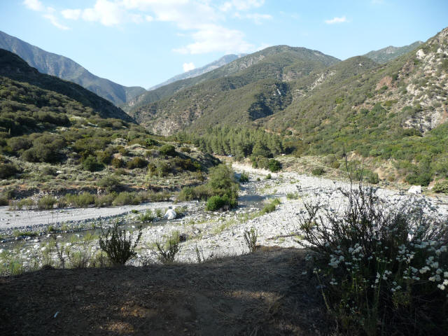
We arrived at the car at 5:57, and so 11:23 for the whole hike. Jim's estimate was not far off! Jim lay in the back and I drove, with the air conditioner on at the max. We needed to stop for gas, and Ernie offered to buy some drinks at the station. Jim thought he might be low on electrolytes, so Ernie got 4 liter bottles of gatorade (the 4th was free) and again although I didn't drink much they both finished off theirs. Jim felt quite a bit better after that, so the electrolytes must have been important indeed.
We ended up going to Hakata Ramen Shinsengumi as originally planned, and by now Jim was back to his old self again, which was wonderful to see. If it had been scary for us watching him I'm sure it must have been even more frightening for himself. He said he'd never felt that way before. Hopefully never again! It's incredibly lucky we brought so much water and that it somehow all worked out okay. I'll certainly always bring more than I think I need in the future, especially when it's to be hot. And we'll have to be very careful with Taboose Pass next month.
I can see why Jim waited 9 years between the first two hikes up Iron Mountain and 19 years before this third time. I'm glad I did it (although it would have been nicer to have less adventure!) but the hike just wasn't a whole lot of fun (except for Jim and Ernie's company). It wasn't particularly hard except for the weather and the steep slippery sections. I felt fine at the end, and surprisingly my legs were not in the least bit sore--it seems I'd gotten that taken care of after the Baldy hike. Certainly I've done harder hikes although not in the San Gabriels. And I've done plenty of hikes that have been a lot more enjoyable as well. I'd rather concentrate on them, and I'd be surprised if I ever do this hike again, but one never knows.
I'd forgotten a couple interesting events regarding maps when I first wrote this report. One was that on the way up my map somehow fell out of my pocket, but luckily Ernie saw it and picked it up. Otherwise I would have been worriedly looking for it the whole way down! Jim had his own older version of the map, but something interesting happened to his map during the hike. I'll let him have the last word: "Iron Mt. was on a part of my map that wasn't waterproofed, and it was completely obliterated by rubbing against the water bottles. Somehow this seems fitting. I do not plan to return for a 4th ascent!"