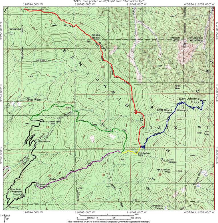
The plan is to do the Fuller Ridge Trail (the red route) to the Deer Springs Trail (blue), and return via the same route. The Tom Harrison San Jacinto Wilderness Trail Map claims the one way distance is 7.6 miles, whereas John Robinson's San Bernadino Mountain Trails claims the roundtrip is 12 miles, but then in his description he has the one-way distance at nearly 8 miles. So say the former is more accurate and the round-trip distance is 15.2 miles. Starting elevation is 7720 and San Jacinto Peak is at 10804, so a gain of 3084. So this will be a longer hike and at higher elevation than the Mt. Baldy hike of the previous week, but less steep and less elevation gain. It should be part of a nice progression leading to the Vivian Creek Trail hike up San Gorgonio Mountain planned for July 23.
I then have one more week before my trip to Colorado (August 7-10). So July 30, assuming I survive these hikes, I could get in one more hike up San Jacinto. A good route to try would be the Marion Mountain Trail up (purple, yellow and blue; 5.9 miles) and then the Seven Pines Trail down (blue, yellow and green; 6.9 miles). I'd then have to walk back to the car along the road (shown in black) for another 4 miles (or do that at the beginning). So 16.8 miles and both trailheads are at about 6300 feet so about 4500 feet elevation gain.
Another possibility, not shown on the map, is the Deer Springs Trail all the way from Idyllwild to the summit. This would be 19 miles roundtrip starting from 5620, so 5184 feet elevation gain.
I don't recall when I first heard of the Pacific Crest Trail (PCT), but I immediately became very interested in it. What a fantastic idea to have a 2650 mile trail from Mexico to Canada, following the crest of the great mountain ranges of the west coast. Although I doubt I'll ever do a thru-hike, I'd certainly like to day-hike or backpack sections of it. In my first hike up Half Dome in August 1999 I first walked (if only for 2.5 miles) on the John Muir Trail, and a month later when my wife and I hiked up Half Dome together we came back via the Muir Trail and so did a little more. The Muir Trail (218 miles from Mt. Whitney to Happy Isles) is another of the great trails in the US and happens to coincide with the PCT for most of the Muir Trail's length, but that doesn't include the section from Happy Isles to Tuolumne Meadows.
The first time I actually saw the PCT, then, was on an unlikely occasion--in the middle of a bike ride from the Bay Area to Las Vegas via Death Valley. We crossed the Sierra Nevada at Walker Pass on Highway 178, and what should be there to my surprise but a sign for the PCT! I must say this was one of the highlights of the trip for me. This beautiful trail leading off into the unknown...it seemed it would be so much fun to hike along it. Little did I know that although the Owens Peak Segment lasts for only 41 miles, if you keep going for 113 miles from Walker Pass you reach the junction with the Muir trail, near the latter's other end at Mt. Whitney.
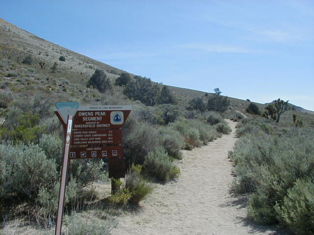
This picture was taken May 1, 2000. There's also a picture of me in front of the trail heading south in Mike's trip report. This trail of course leads toward the section of the PCT that I hiked along on this trip.
The first time I actually hiked on the PCT was at the beginning of my trip around the High Sierra Camp Loop. The first couple pictures from that trip may have been taken while on the PCT, which I was only on for about 5 miles up to Glen Aulin.
In December 2002 I drove to Joshua Tree for the first time to climb with some friends, and from the 10 highway I first saw San Jacinto Peak. It was a huge surprise to me as I had no idea there were such big mountains near LA, and the desert face of this mountain, which rises 10,000 feet in 5 horizontal miles, is one of the steepest escarpments in the US and incredibly impressive. (According to this article it's nearly 7 horizontal miles, and the escarpment is the steepest in North America. The 5 mile figure is from John Robinson's San Bernadino Mountain Trails, but he says "almost 10,000 feet" and is probably measuring from a different point.) I haven't taken a picture of this face yet myself, but there are pictures everywhere, including on the cover of Robinson's book, no fewer than 3 in Pacific Crest Trail: Southern California, and so forth. Strangely I can't find any pictures on the web just now, but there are a couple on my Joshua Tree page taken from there that give something of an idea, except they are from much farther away and a different angle.
Anyway I of course thought it would be great to climb this mountain, even though it looked like a dangerous technical climb that was beyond my ability (Robinson describes some routes in his book, which are 4th class). I didn't realize that there were all sorts of easier trails up the much more gentle backside of the mountain. Of course once I found out about these I had to try one out. Robinson's book describes several and I picked the Fuller Ridge Trail as the first to try, as it was one of the shorter and easier trails. Also a big draw was that it intersected the PCT for 5 miles, so another chance to hike along a little of the PCT! In fact this segment is famous for being dangerous, because it is often covered in ice in the early season when south-to-north thru-hikers reach it. At the time I did it the trail was of course completely dry and seemed so innocent it was hard to believe it could be dangerous. I was expecting something more scary similar to some sections of the Devils Slide Trail I'd done last week on Mt. Baldy, but there was only one section a few feet long that seemed like it would be dangerous. But I'm sure it's very different when the trail is covered with ice and snow.
Incidentally on that drive to Joshua Tree I unknowingly crossed the PCT again, which intersections the 10. If you hike along the PCT southward from there about 20 miles, you'll reach the Fuller Ridge campground where this hike begins.
Part of the idea of doing these hikes now is to get in shape for Longs Peak in August, so I am especially concerned with how my fitness seems to be. Mt. Baldy took a lot longer than I expected, and one reason I attributed that to was not being in the best shape. For this hike I felt much better. I'd done a 50 mile bike ride into the Santa Monica Mountains above Malibu, which was itself wonderful, as well as my usual ride up Sepulveda Pass the day before this hike, not to mention the Mt. Baldy hike the previous week! Furthermore this hike, although longer than Mt. Baldy (15.2 miles vs 11.9) and at higher elevation, had less elevation gain (3084 vs 3904) and combined with the longer distance it seemed this trail should be quite easy. Especially the Fuller Ridge section, which gains a mere 1220 feet in 5 miles. Indeed the PCT, which was designed so that horses can walk the length of it, is fairly gently graded throughout. So I expected to really cruise up (and down) this trail. Also I expected no knee problems going down, and that at least turned out to be true.
Once again however I was surprised to go much slower than I expected. I thought it was realistic to make it up in under 4 hours and down in under 3 hours. Instead it took 4:30 to go up and an embarrassing 4:15 to go down. The main reason, I think, was that just like last week (you'd think I'd learn) the trail was harder than I expected. In particular the Fuller Ridge segment: It's hard to tell looking at the topo map, but the trail, far from being a gentle incline, is actually constantly going up and down. In fact I'd estimate there's a good 500 feet total of descent, which means another 500 feet of climb, and of course another 500 feet of climb on the way down. So there was likely more total climb than the Mt. Baldy hike. The trail was fairly gently graded and a good quality trail, but somehow that didn't translate into speed--I hiked rather lethargically all day. Perhaps part of that was due to the elevation, and part to not being in as good of shape as I hoped. I might have been battling yet another bug, as my son turned out to have a fever when I got home. I used to only get sick about once a year, but in the last few months I've been sick four times, plus battling illness successfully at other times. I'm sure just about everything I've gotten from my son.
I was wondering if the hike at elevation last week would have any positive benefit this time. I actually believe it did--I didn't feel my heart beating fast so much as I did last time (although maybe that was due to the less steep trail too) and generally felt more comfortable, even though this trail was at higher elevation than the last.
I took 3 liters of water again, but with the longer trail was worried that wouldn't be enough. So I brought another liter and drank about half of it before starting (and the rest at the end), which was a good idea and which I'll do more in the future. The day turned out to be cool and much of the walk shaded by trees so that helped, and the water was just enough. Again I passed some streams and also some humans who offered me water, as I'll describe below. As for food since I figured this would be longer than last week I took along the same food as before, plus an extra packet of cheese crackers and a box of Cracker Jack. I ate everything but the extra cheese crackers, and that seemed to be enough, but thinking back maybe more food would have helped. I'll perhaps bring a sandwich next time.
I underestimated both the time of the drive and the hike, and told my wife I'd be back by 6pm, figuring that was well on the safe side. It turned out I'd call her around 5:30 from Idyllwild saying I'd be back by 7:30, 8, or worse if the traffic was bad.
Now I'm worried about Vivian Creek Trail up San Gorgonio Mountain next week, which will be much harder: 15.6 miles with 5420 elevation gain, going up to 11,502 feet. At least not too much up and down, apparently. I'd better expect this one to take 11 hours, and I hope that's not an underestimate.
I expected to get to bed earlier the night before this time, but somehow stayed up until midnight and so only got 4 hours of sleep. Once again I got up at 4am and was off after getting gas (there is conveniently a station just before the 405 onramp, which is only a couple minutes from our place) at 4:40am. The drive was quite a bit longer this time, and what's more I had to stop at the ranger station in Idyllwild to get a self-issue wilderness permit, which added 16 miles to the trip. I got to the ranger station in about 2 hours, and then went back to the 8 mile dirt road heading up to the Fuller Ridge campground and trailhead. This dirt road was what I perhaps dreaded the most the whole trip, and for very good reason. It turned out to be reasonable as far as dirt roads go, meaning I could get my Civic up it, but just barely. It was still a completely miserable experience, both up and down. Thankfully the steeper switchbacks were paved, but it was very slow, bumpy and dirty going, taking a half hour to go each way. One interesting incident on the way up is that I ran into a couple wolves or coyotes. It was pretty cool, especially since I was safely in my car.
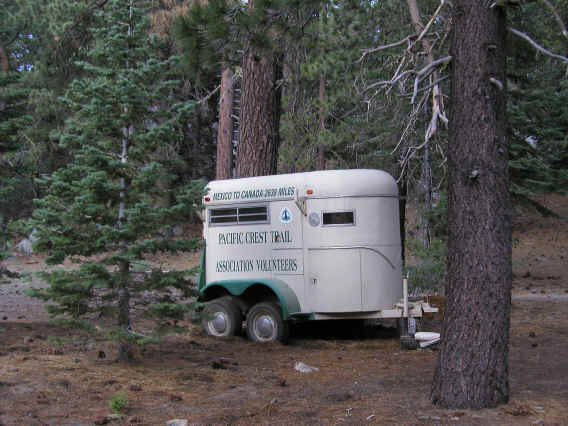
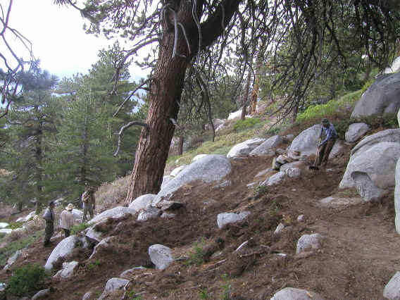
Finally I made it to the trailhead, and not really knowing where to park ended up in a space probably intended for campsite 6, reserved by the Pacific Crest Trail Association Volunteers. They had a huge and lavish camp set up--these people really knew how to camp. I didn't go to talk with them, but a woman called out good morning which was nice. This was all very cool to see given my interest in the PCT. The group was there to do maintenance work on the trail, and I would run across those people later. What I first noticed was one of their horse trailers, pictured below. They had at least one other one, bigger, and I was amazed they got these things (with horses in them!) up that steep dirt road.
I drank some water, ate my energy bar, and started off. Of course I had to take a picture of the sign at the trailhead with the famous PCT logo. I was off to hike part of the PCT!
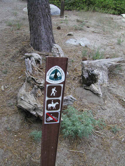
Starting out, I was soon reminded of a disadvantage of the PCT: As the sign indicates it was intended for horses as well. I immediately ran across a lot of fresh horse droppings which I had to be careful to avoid. The John Muir Trail is also for use by horses, which is one reason I almost always choose the Mist Trail, even on the way down, when hiking Half Dome. Here it was clear that horses had recently been on the trail, and sure enough I would run into them later.
Aside from that the start of the hike was quite pleasant. It was mostly in the woods, with a lot of nice trees and some beautiful wildflowers. But not much of a view. The sky was also mostly overcast. Indeed the weather forecast was for a 30% chance of thunderstorms, so I was a little worried about that. Due to the long drive I didn't get started until 8am, but I figured I should make it to the top by noon and be done by 3pm, which should hopefully beat out the storm. Such wishful thinking.
Since I was coming down the same way I went up, I figured I'd take pictures only on the way down. This way I'd keep my momentum and also have a good idea of just what I wanted to take a picture of and so not waste so much time trying to find the best views. In any case it turned out there were very few views and good pictures to be had on this trail at all, which was something of a disappointment. Mostly it was like a walk in the woods--enjoyable enough, but I'm more interested in spectacular scenery. Like Mt. Baldy, there were a fair number of flies and so forth swarming around me, but again no mosquitoes (save down at the campground). It seemed like the flies weren't nearly as bad as Mt. Baldy, and again I didn't feel the need for insect repellant.
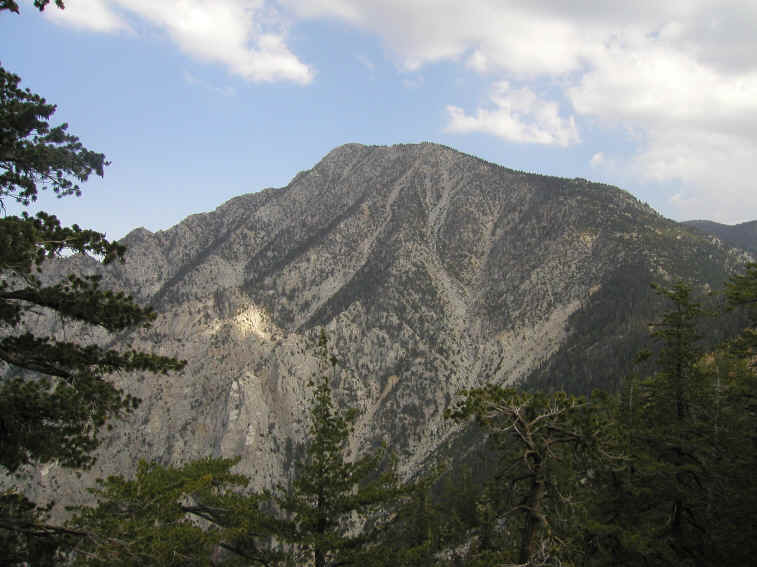
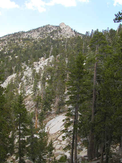
Fairly early on (after 2 miles, say), you get an excellent look at the peak. The trail goes around to the right. This picture was taken on the way down, and so was actually one of the last I took, but it's more interesting to put them in order of the way up.
At some point past this view, I think, I ran into my first navigational problem. I had some trail-finding difficulties on Mt. Baldy, but expected there would surely be no problem on the well-marked PCT! Yet I ran into a place where the trail forked and there was no sign or clear indication of which way to go. Furthermore there was no indication on my map, or indeed any map I've seen, of the existence of this extra trail! I should have asked the people PCT volunteers I met later about it, but I forgot. Perhaps I'll call the ranger's office and ask them. Anyway there was a duck set up, but it was on the trail I'd just come on (so I guess for the south to north hikers which is the normal direction on the PCT). Of the two branches, one went up to the left, while the other looked to go very slightly down. The latter seemed a continuation of the trail I was on, so I assumed the former was some spur up to a view. I continued on the straight route. However it started going down more precipitously, and after maybe 5-10 minutes I decided this was probably not the right trail and backtracked. I had my GPS unit but didn't use it here. Instead I tried out the other trail and it did seem more likely the right one, so I continued on. Indeed it was, and this motto of when in doubt, go left and up, would be one that repeated throughout the hike, although of course I didn't see the pattern until it was all over.
The next interesting experience of the hike was running into a clearing with a half dozen horses, a lot of hauled equipment and so forth, but not a human being to be seen. It was both beautiful and eerie. I took some pictures here both on the way up and down, but the one I've used below was from the way down. One on the way up came out very well but only looks really good at full-size.
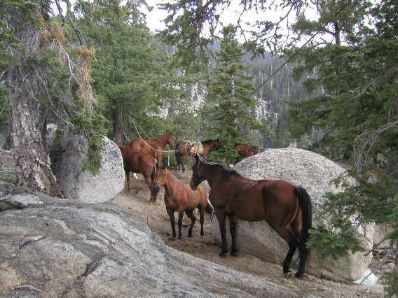
This is the second place I lost the trail. What happened is that the trail skirts around the edge of the clearing, but the horses drew me in and I became sure the trail went through the clearing. However no matter which way I went (and I tried several ways, often having to walk between the horses which fortunately were very well-behaved) nothing seemed right. I was especially worried because it seemed like this might be where the junction with the Deer Springs Trail was, which I was supposed to take next and I didn't want to end up on the wrong trail. The experience of the mystery trail earlier on left me doubtful of everything and often worried I was somehow on the wrong trail. I was worried also when the trail headed right, switchbacking downhill, these sort of details not represented on the map. But that was just part of what the trail did. I should have read the PCT guide more carefully: "The PCT's route along Fuller Ridge is a tortuous one, composed for the most part of miniature switchbacks, alternately descending and climbing, which wind under small gendarmes and around wind-beaten conifers."
After a bit I got worried. I could hear some human voices in the distance but could only tell the general direction, which wasn't enough for me to guess which way to go. I sat down on a rock, ate a little, and turned on my GPS. I had loaded a map of the region into it but hadn't set any waypoints. And the map wasn't quite detailed enough to tell me where I was, so for the first time ever I read off the UTM coordinates and determined my rough position on the topo map I'd brought. This worked well and gave me an idea of where I was at least, which was roughly where I thought (not yet at the junction). But I still didn't know where the trail was. So I went back to the sure trail and looked around some more, finally realizing my mistake of going into the clearing. It was a little tough to see the trail but not too bad.
A little further down (maybe another 10 minutes or so) I finally ran into the people. They were eating at the moment, but when I ran into them again hours later they were hard at work, and I took a picture of some of them then. It looked like very hard work, but at least it was cool out. I should have asked if they thought it would rain, but then afterwards I figured they wouldn't be there if they thought there would be a thunderstorm. On the way down we did talk about the weather and it turned out they knew no more than I did--they'd heard the 30% chance of thunderstorms also. They were very nice and we chatted briefly. I asked if the junction was still ahead and they said indeed--still a ways to go.
The junction didn't turn out to be quite as far as I expected from their comment, but I did pass a small waterfall before it, I believe. The waterfall is a bit hard to make out in the picture, but the rocks look cool anyway. This was also taken on the way down.
All the while the clouds were getting darker and it was threatening to rain. Now I don't have much experience in mountains, but from bicycle trips and general walking I've gotten reasonably good at interpreting clouds. These didn't look like real rain clouds, and I didn't imagine much more than a sprinkle. But again it could be quite different in the mountains. I started to feel a few drops and got more worried. But I figured I'd keep going--I was far enough in that I was going to get wet anyway, so I might as well visit the peak. But if it started raining hard I'd turn back. At least I was not too worried about lightening, since there were plenty of trees around.
Nearer to the top it did start raining, but only a light sprinkle. In fact it felt quite good and I never felt the urge to pull out my rain jacket. After less than 10 minutes it stopped, and the sky actually began to clear right around when I reached the peak. So that was really nice. And very lucky--as I mentioned above I underestimated how difficult this hike was even in good weather. In a rain storm it would have been completely miserable. Also I wouldn't have taken any pictures....
Returning back to earlier in the trail, sometime shortly before or after the junction with the Deer Springs Trail (which I did find, although only the PCT segments are marked--also the map indicates there's supposed to be a mostly treeless area adjacent to the junction which in person seemed clearly not true) you get to see some more excellent scenery, which the camera cannot capture well. I should have paid more attention to where I was and what this was, because now I'm not sure of either. My guess is that this is either Marion Mountain (10,362 feet) or Newton Drury Peak (10,160 feet). Again this picture was taken on the way down, and you can see the good weather.
When you reach the junction you take the Deer Springs Trail, which starts gaining elevation much more rapidly. In a mile you supposedly climb 860 feet to the Little Round Valley campground in one mile, but it didn't feel that steep. I say supposedly because my altimeter (a Suunto Vector watch I've had for many years) read only 9700 at the camp, whereas the map says 9800. I took this as a sign that a low pressure system had moved in and there might be a storm coming. However a sign for the camp said it was at 9700 feet, which was amusing.
The campground looked huge, and I wasn't really sure where its boundaries were and where you were supposed to put tents. It was fairly flat and had a nice stream running through it. Not a soul was there, although on the way down I ran into some backpackers heading toward it for the night. There were a lot of trails crisscrossing through it, and for once I picked the best trail to go through (which turned out to be to the right this time, on the way up). I should mention that again going on a Wednesday was a great idea because I saw very few other people. A few more than Mt. Baldy, which was a little surprising since San Jacinto is more remote and requires a wilderness permit. But still just a handful, and they were going the opposite way so I only saw each for a few seconds. Otherwise I had the trail to myself.
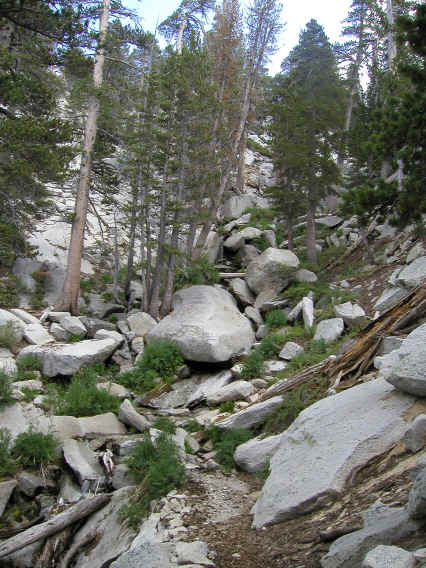
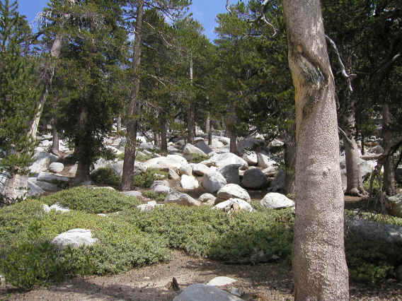
This trip had a couple elements that made me think of Longs Peak. One was the threat of thunderstorms. Another was a sort of "boulder field" that I'm sure is very different from the Boulder Field of Longs Peak. But anyway there's this large area (probably much of the mountain, actually, but it is particularly pronounced as you near the top) that is just full of boulders and trees, and that's all you can see. This picture should give an idea (again taken on the way down).
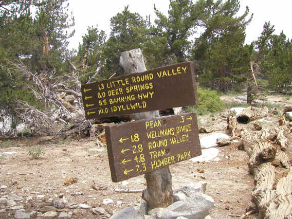
Finally 1.3 miles and 800 feet more of climbing past the campground you reach a well-marked junction indicating only 0.3 miles left to the peak itself!
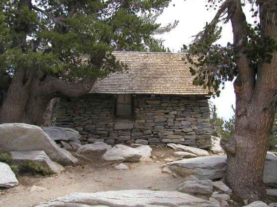
A little before the summit is a nice stone hut which I'd read about. I figured this would be good shelter if it rained, but by the time I got to it the weather was already nice. I didn't try going inside which was too bad; I'll have to next time. I remembered to look for a summit register on the peak this time, but didn't find it. When I got home I found out the register is in the hut! So once again I missed a chance to sign a summit register. This picture was taken on the way down.
The peak itself was quite a surprise. First of all the path pretty much disappears at the end, into a big pile of boulders. I was expecting the summit to be some large expanse like Half Dome or Mt. Baldy or Longs Peak, but it is actually just a pile of talus, the peak being the rock that happens to be on top. So you have to do some 2nd class scrambling at the end (another similarity to Longs Peak?). This was quite fun but also a little scary as I didn't want to go the wrong way and get in trouble. I backtracked a few times when it seemed the path got closer to 3rd class. Again the mantra turned out to be left and up. At least the up part turned out to be obvious. I was worried I was going to get quite lost going down, but knew there was the stone hut which should provide some guidance, and indeed it was a big help once I got low enough to see it.
Fortunately there's a sign so you know when you're at the top. The picture doesn't give a good idea of the situation at all. It seemed very raw and wild, like a real mountain should be, and so quite exciting to reach the top. A bit scary, too, especially as footing was not so good to take pictures.
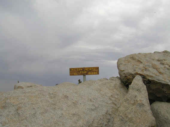
There's a famous quote by John Muir: "The view from San Jacinto is the most sublime spectacle to be found anywhere on this earth!" Even though I couldn't see very far on this day, I wouldn't disagree. This was surely the most spectacular scenery I've seen from a mountain top yet (if Muir is to be believed, ever). Not only do you get a beautiful panoramic view, but there's a great variety of scenery at this meeting place of several climates. On a very clear day you can supposedly see all the way out to the ocean to west and to Arizona to east. That would be amazing.
Unfortunately there's no way to capture this view by camera, and none of the pictures I took came out well. But here are a couple just to give a vague idea of what you can see. I didn't really pay attention to what I was photographing, but fortunately I found a site with much clearer pictures and directions identified properly. This guy took a different trail up, the Devils Slide Trail, that I didn't even know existed until I saw his page. It looks like an excellent trail and one I should certainly try out. San Jacinto Peak seems to have the biggest number of day-hikable trails to the summit of any of the nearby mountains, ranging from a 12 mile roundtrip from the top of a tram ride that takes you to 8500 feet (that will be a fun one to do with friends who visit), to the famous Cactus to the Clouds hike (see also here for waypoints and here for more info), which completely overlaps the former but is 20-22 miles total, with the the first 14-16 miles climbing 10,500+ feet, apparently the greatest elevation gain of any hike in the continental US.
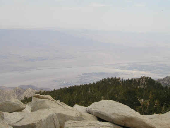
Anyway the first picture is to the northeast and Palm Springs.
.
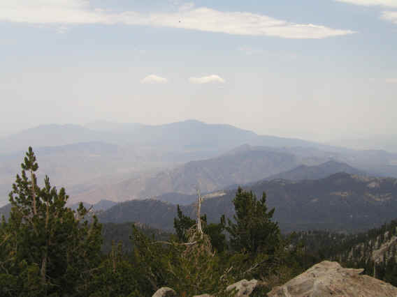
Below is a view to the southeast and more of the San Jacinto mountain range.
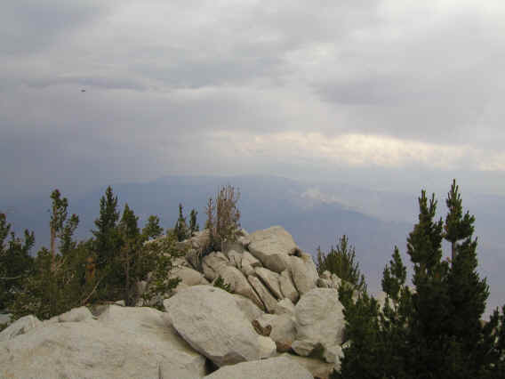
Finally to the north we just barely make out the San Bernadino mountains and San Gorgonio Mountain, the goal of next week. Again the pictures on the site noted above are much clearer and I highly recommend looking at them.
The peak isn't really a place you want to hang out on for a long time, so I soon headed down. The hike back is when I took almost all the pictures, and it ended up just being a long slog down, with a lot more up than I expected on Fuller Ridge. I got back to the car by 5pm, down the dirt road a little after 5:30, and then had to worry about traffic since it was getting into rush hour. Fortunately no traffic on 243, and I tried taking the 60 back into LA for a change. It was a nice alternative and against the rush hour flow, so it went very fast. Then the 10 out of downtown LA was also against the flow. The 405 was of course jammed in both directions but I only have to be on that for a mile or so. So it only took 2 hours to get back from the base of the dirt road (arriving home about 7:40pm), about the same amount of time it took to get there. I should add that the San Bernadino mountains are quite spectacular seen from 243.
Overall an excellent hike. Although it was exciting to be hiking on the PCT and the trail is in great shape I'd have to say the Fuller Ridge segment itself is not all that interesting scenery-wise, with just a couple really great views. So I'm not too tempted to hike it again, especially given that 8 mile dirt road. Next time I'll try one of the many other routes to the summit, which have much easier drives to the trailhead. Again Marion Mountain/Seven Pines may be what I'll hike in two weeks (or Devils Slide), although if San Gorgonio turns out to be especially good I might try San Bernadino Peak (10,649 feet) instead. That trail is 16 miles roundtrip with 4600 feet elevation gain. There are plenty of great mountain hikes left to try here.
Distance up/down: 7.6 miles
Total distance: 15.2 miles
Time up: 4:30 (8am to 12:30pm)
Time on top: 0:10
Time down: 4:15 (12:40pm to 4:55pm)
Total Time: 8:55