[8/4/06: Corrected the trail length from 7.8 to 8.6 miles, and the trailhead elevation from 6160 feet to 6080 feet. See the 2006 trip report.]
This was the third of my hikes up the three major peaks of Southern California, the other two being Mt. Baldy and San Jacinto Peak. This reminds me of my "Conquer the Mountains" bicycle trips back in 1998, in which I bicycled from home up the three major peaks of the Bay Area. Those three mountains were much smaller and had paved roads leading to the top; the challenge was to cycle to the top of each as part of a 100+ mile roundtrip. Here the challenge was to hike up from a trailhead reached by car. It's hard to pick which was more difficult, but I'd say the cycling trips were probably harder overall.
San Gorgonio Mountain is the highest peak in Southern California at 11,502 feet. The Vivian Creek Trail is the shortest route to the summit, 8.6 miles one-way for 17.2 miles round-trip (at the time I thought it was 7.8 miles one-way for 15.6 miles roundtrip, however). The trailhead is at 6080 feet, so 5422 feet of elevation gain. This was going to be the toughest of all three hikes in every respect: length, elevation gain, and elevation at the top. I hoped the other two prepared me enough.
Perhaps the best preparation I got was simply to lower my expectations. I'd done my favorite hike up Half Dome in 3:45 to the top (2:55 a couple years ago), and 7:40 total; this for a 14 mile hike gaining 4800 feet. But Half Dome is only 8800 feet high, and elevation really does seem to have a major affect on my speed. After taking 9 hours to do San Jacinto Peak, I figured 6 hours up and 5 hours down, or 11+ hours total, was a realistic goal for this hike. I hoped that I could somehow get up in 5 hours and down in 4, though. When I started the hike at 6:45am, I was hoping to get up by noon at least which would be 5:15. It turned out that was a little too optimistic: I made it up in 5:30. Still I was pretty happy with that, and happy also with 4:20 to get down.
I found myself slowed down considerably above 10,000 feet. I felt fine and was breathing fine as well, but my heart would start racing and I had to stop every minute or so to let it slow down. It didn't seem like the trail was that steep but going down I realized it was steeper than I'd thought, so that might have been a factor as well. This doesn't bode well for Longs Peak, though, where the trailhead is at 9400 feet. Going down I had no trouble with my heart rate at all, though. I did have knee problems on the steep switchbacks at the very end (that is, the very beginning), but fortunately there was only a mile left and I made it down without too much pain. Mostly I was just exhausted after 10 hours of hiking.
This was probably the second most difficult hike I've yet done, the most difficult being North Dome in Yosemite which was a similar amount of climb (although at lower elevation), but a total distance of some 20 miles. One can of course make up arbitrarily more difficult day hikes either here or there, but I think I'd better get into shape to do them before I try. I expect Longs Peak will be harder than anything I've yet done, but I hope not too much harder. I felt in okay shape before this hike but not particularly strong.
For food this time I took pretty much the same as the other two trips, plus a couple tiny boxes of raisins. I was going to bring a sandwich as well due to the hike being longer, and even deliberately walked past the 7-11 on Westwood Blvd the evening before, intending to stop by and buy a sandwich. However I somehow completely missed the store! Just as well, as I didn't even eat everything I brought (leaving the candy bar this time). Every trip the item that tastes particularly good changes. This time it was the Slim Jim beef jerky (a little different than the kind I brought the previous trips) and the raisins.
I was worried about water since 3 liters had been just barely enough the previous two trips, and this one was going to be longer and harder, and at higher elevation. However I didn't want to carry any more than that. There were a few water sources on the hike, though, and I brought iodine tablets just in case. (The excellent San Gorgonio Wilderness Association page has detailed updates about water availability along trails.) Once again I drank nearly a liter of water before starting. This time, however, I somehow didn't need as much water as the previous hikes. I have no idea why, since it wasn't particularly cool. I drank only a liter on the way up, and then another liter on the way down, and so was still carrying nearly a full liter by the end. So I hauled around 5 extra pounds for nothing.
My GPS unit, a Garmin GPS III+, had proven useful the previous hike, but it was old and I'd been intending to replace it for a while. I was waiting for Garmin to release a sequel to their eTrex series, but they seem to be very slow to improve their products. On the other hand the prices had come down quite a bit, so I didn't feel bad about buying one. I ordered the eTrex Legend for $180 from a place in Las Vegas through the internet, and it arrived the day before the hike. Much smaller and lighter than my old unit, with far more map memory and a bigger screen with higher resolution and grayscale! Progress is wonderful. I loaded it with topo maps of much of SoCal, plus 50 waypoints for my hike. It turned out I didn't need the unit at all--the trail was very easy to follow with all junctions clearly marked. But it was still fun to power it up at various rest breaks to check out my progress.
And now details of the hike itself....
I managed to go to bed at 11pm the night before this time, but somehow slept very poorly all night. Still I had no trouble getting up at 4am, and somehow felt the least sleepy of the three trips. Once again I stopped for gas and was off at about 4:40am, or maybe a couple minutes later this time. The 10 freeway in the early morning now felt like an old friend. More traffic than the previous two weeks, it seemed, but no slowdown. This was a 100 mile drive compared to 66 miles for Mt. Baldy, but it took only slightly longer--just over 1:30. The difference is that you can go fast for almost the entire drive. In particular route 38 takes you up to about 4500 feet and the speed limit most of the way is 55mph. Route 38 is part of the Rim of the World Scenic Byway, and is a very nice road through beautiful scenery. Well-paved and with little traffic, it seems it would be an excellent cycling route, so I'll have to try that some day.
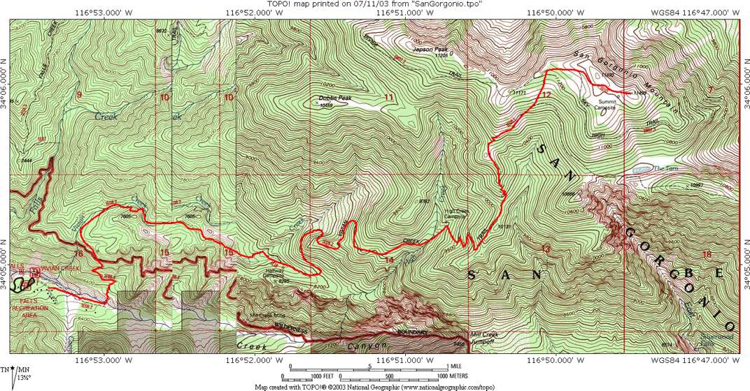
After the ordeal of getting to the trailhead last week, it was a pleasure to find it so easy this time. The trailhead was well-marked as you can see below, with plenty of parking and an outhouse. There's a quota on all the trails into the San Gorgonio Wilderness, and I made sure I had my wilderness permit with me. I never saw a ranger, though. In fact once again I had the mountain nearly to myself. I passed a day hiker near the peak (he was just coming down, so I had the summit all to myself), and saw a handful of people in the backpacker camps along the way. Also at the very end I saw a couple people going up the trail carrying almost nothing; they were probably locals just hiking up the first mile of switchbacks (up to the wilderness boundary) for exercise. Again wonderful to feel alone on the mountain.
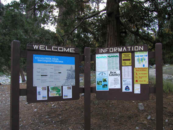
Soon after the start you have to ford Miller Creek. Now in the early season after a big snowfall this wide riverbed could be filled with water, making for a dangerous ford (and indeed there's a sign that warns of this). However now there was just a trickle of water to cross, not even visible in this picture. This was taken on the way back from the far side.
After the ford the trail heads up along Vivian Creek, immediately starting up switchbacks which are the only really steep part of the hike. They are steep indeed, gaining 800 feet in about a half mile or so. At the one mile point you reach the boundary of the wilderness, beyond which you have to have a permit.
Just 0.2 miles further you reach the first of four backpacker camps along the trail. For a place with quotas they certainly have plenty of campsites. This is the Vivian Creek camp, and the trail crosses the creek as this point. Strangely on the way back I crossed the creek at a different place than the way there (which I couldn't find again), and saw yet a third crossing. Water was flowing pretty well in the creek still.
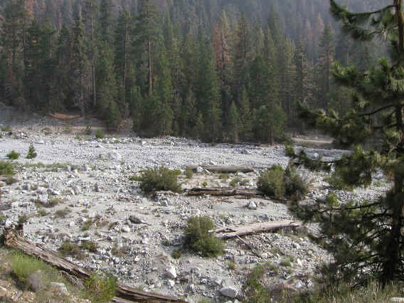
Much of the trail lower down was in the woods, which were quite nice as this picture (taken on the way down) shows. There were a lot of wildflowers and also some trees of different colors, so a pretty place to be.

I should mention the insect situation. On the way up this was not too bad. There weren't many mosquitoes, and they seemed to disappear above 9000 feet. There were flies everywhere including on the summit, but they seemed less persistent than the previous two hikes. On the way down, though, I ran into some sections with a lot of mosquitoes and other bugs. It was quite bad and if you stopped for any reason they would swarm around you. This was the worst I'd encountered of the three hikes and it was definitely good motivation to keep moving. I ended up with quite a few mosquito bites.
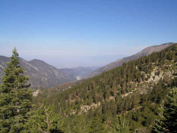
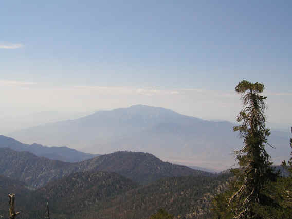
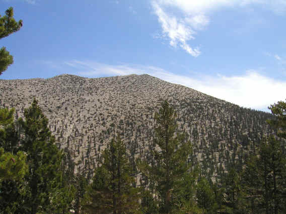
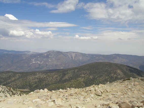
After a while you get up high enough to get your first view from the trail down Mill Creek Canyon to the west. The mountain that can be barely seen in the distance is I believe Mt. Baldy.
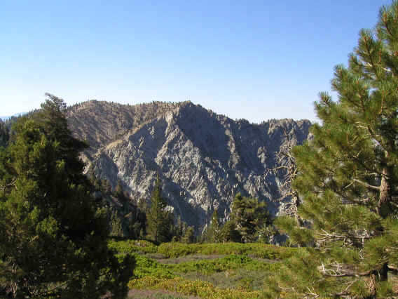
As you go up you see more of the mountains lining both sides of the canyon, with the bottom of the canyon, sort of looking like a slanted meadow, down below. Here's the mountain ridge to the south of the canyon. This is probably Galena Peak (9324 feet).
At some point I passed the Halfway Camp, which is actually less than a third of the way up the trail so I'm not sure how it got its name (it is about halfway between the start of the trail and the next camp, though). The next camp after 2.3 more miles is High Creek. There was no one there on the way up and I stopped at one of the sites to rest and eat some food. A very pleasant location next to another creek running strong.
After High Creek there are a series of switchbacks that are extremely long and almost flat, just the opposite of the switchbacks earlier. You can see them above or below you and it's almost infuriating how far you have to go back and forth gaining almost no elevation. You can see several places where people have cut the switchbacks, and although that's illegal (and a bad idea) I can understand the temptation.
At some point after the switchbacks you get your first view of the desert face of San Jacinto Peak, which is terrific. You get nearly constant views the mountain, Fuller Ridge (the right side ridge, where I hiked last time), San Gorgonio Pass, and so forth. Unfortunately it was rather hazy this day. This picture was taken not at the first glimpse but a little later on.
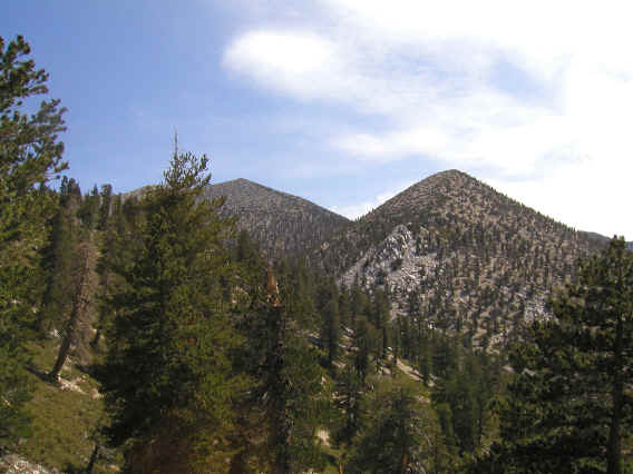
A little later you get your first view of San Gorgonio Mountain (to the left). It still seems so far away.... The peak to the right is unnamed (10,997 feet).
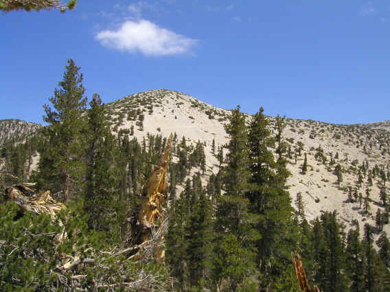
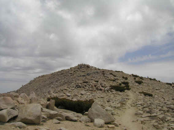
As you near the tree line, you can see the entire remaining path to the top, which is very cool. It's hard to see in this picture, but there's a sort of diagonal path across the face of the hill here, leading to the saddle. The diagonal path on the side of the hill was fine on the way up, but somehow a bit scary on the way down.
The saddle leads directly to...San Gorgonio Mountain! Here the twin peaks can be seen. It seems from this picture that the one on the right is slightly higher, and indeed it is. However on top I couldn't decide which one was higher. In the old measurements, they are 11,490 and 11,499, so that's pretty close.
As mentioned above I was going very slow along this last part. However it was beautiful and certainly the highlight of the hike. Particularly great was the last stretch along the saddle, as you can see the peak ahead..
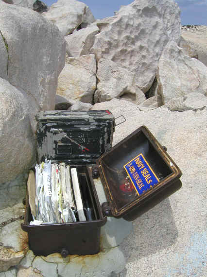
Summit registers in a box on the northwest peak. At first I thought the box was for emergency equipment. I wasn't sure which notebooks to sign, but the black book on the right looked the nicest so I opened it and the most recent entries seemed to be there. I wrote my name and some inane comments. This is the first time I've signed a summit register.
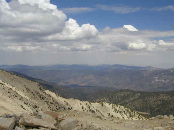
Two parts of a view from the top; I forget the direction. There are other great views and San Jacinto Peak is also clearly visible, of course. Notice some possible rain/thunderstorm clouds. They seemed pretty benign, though, and indeed there were no problems.
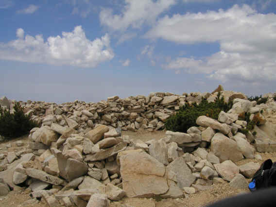
One strange thing about San Gorgonio Peak is that there's a backpacker campsite on top. Each site seems to be enclosed by a sort of stone fortress. I couldn't figure out if the campsite was on the higher peak or the summit register was, and I assumed the latter but had I bothered to look at my map I would have seen it was the campsite peak. I looked at both for the marker with the corrected elevation for San Gorgonio Mountain (calculated with GPS to be 11, 502) but couldn't find it. Something to save for next time.
I stayed on top for a half hour, eating some food, putting on more sunblock, and enjoying the summit. But the clouds seemed a bit worrisome and it was probably over a half hour to get below the treeline again, so I decided I'd better head down. Fortunately it never rained. The trip down was just a long hard slog. Due to my poor memory I'd forgotten most of what happened so the good thing is that it seemed like I was going down a new trail.
On the drive home I stopped by the ranger station, right on the way. I knew they closed at 4:30 and it was already 5:30, but I wanted to see the setup for self-issue permits since the trails have quotas. I found what they do is leave out just a limited number of self-issue permits per trailhead. For Vivian Creek they only had 3, but for San Bernadino Peak they had 5, so it seemed likely if I got there early in the morning I'd get one. Probably best to call the day before to find out the number they're planning to leave out.
The drive home was pretty decent despite hitting rush hour, the only bad spot being the 10 from downtown LA almost all the way to the 405. That segment was fine the week before, and I was only maybe 30 minutes earlier this time.
At this point (7/28) it's not clear what I'll do this week. I might well not do anything, as there's a forecast for thunderstorms in the mountains for most of the week, and after doing all three peaks I don't feel it to be so urgent to do yet another long drive and hike this week. I'll probably decide at the last minute.
In summary San Gorgonio was a fantastic hike, in a way the best of the three although it's tough to compare the three hikes as they were all quite different. In a way Mt. Baldy had perhaps the best overall scenery, and at just 12 miles I still felt I had some energy left at the end which was nice. I'm sure I'll do all three mountains, as well as other mountains around LA, in the near future.
Distance up/down: 8.6 miles
Total distance: 17.2 miles
Time up: 5:30 (6:45am to 12:15pm)
Time on top: 0:30
Time down: 4:20 (12:45pm to 5:05pm)
Total Time: 10:20