
After Wednesday's hike up Baldy I was debating whether to really do one last warmup hike on Sunday before the Sierra backpacking trip due to start Wednesday, July 2. I was a bit sore after that hike and worried more hiking was going to do more harm than good. But by Saturday I felt fine again, and the weather was superb that day, in the low 70s in Westwood with about 50% humidity. The air felt wonderful, and I was in a particularly good mood. I decided one more trip was in order.
This made sense for other reasons as well. I thought this should be my last LA area hike, since after the backpacking trip I wanted to concentrate on the Eastern Sierra before I leave LA, another area that will be much more difficult to get to from the Bay Area. I wanted to give my unused car bike carrier to Lydia and David who had agreed to take it, and I hoped to finally have lunch with Roz as well.
I had been thinking about just what to do for this final hike. An early thought had been San Gorgonio, but I've done the Vivian Creek trail twice already and wanted to try something new. Then I thought of doing San Jacinto Peak via the Marion Mountain trail, which is supposed to be nice and steep, but the drive would be long and there would be the added annoyance of having to drive past the trailhead for several miles to the ranger station to pick up a permit. I was getting sick of driving and wanted to do something closer.
An interesting possibility arose from the Iron Mountain hike. We could see an impressive mountain to the northwest, and looking at my map I thought it might be Ross Mountain. But Jim pointed out that was far too low, and the thought it must be Mount Baden-Powell, which I hadn't at first seen on the map. Sure enough it was. Baden-Powell was also very impressive from Baldy (see that trip report for two pictures). So I thought that I should hike up it. The only problems were the long drive (it seemed near 2 hours) and the short hike (only 8 miles roundtrip) which didn't really justify the drive. I tried to find a hike to the summit that would involve a longer hike and shorter drive, but there really wasn't anything else feasible. However in Schad's guide he mentioned a 13.4 mile hike that first summits Baden-Powell and then descends a ridge to Ross Mountain! I love ridges, and due to my mistake Ross Mountain had a special meaning to me, so this seemed like the perfect hike and I thought I'd try it. The total 5500 feet of climbing would be less than my previous two hikes, but still a good workout. The flow of the hike seemed very interesting to me too, as you descend at the far end. So climb, descent, climb, descent, which seemed nice.
Lydia and David were planning to go clubbing Saturday night, so a late meeting with them seemed just right. I figured I'd leave home around 4:30, start the hike around 6:30, and hoped to finish in 6 hours or a little more. I said (via email that it turned out Lydia didn't read until Sunday night) that I'd probably be done between 12 and 2 and would make it to Lydia's place an hour or so later. My initial plan was to drive all the way up the Angeles Crest Highway to Vincent Gap (much shorter than the other way, but likely longer time-wise) and make a big loop out of it, but I had a vague recollection that the road might be closed, and looking it up sure enough it was closed between Islip Gap and Vincent Gap (and apparently has been closed for the past 4 years!). So I drove via 210, 15, 138 and 2, the same way I'd taken before to get to Mountain High, and indeed Vincent Gap is just a few miles beyond Mountain High. I left at 4:40 and got there at 6:15, so just over 1.5 hours and not bad at all.
Surprisingly there were already a couple other cars in the lot and a couple guys started just before me, although they went toward Mine Gulch. Here's a picture taken at 6:19 at the trailhead just as I started.
The weather was excellent and the trail, gaining 2800 feet in 4 miles, reminded me immediately of Mount Si, which gains 3200 feet in 4 miles. So 700 feet elevation gain per mile versus 800, which is a fair difference and the hike certainly seemed less steep, but still a good workout. What's more, Mount Si has posts every half mile, and this trail too has posts of a sort, but just a few arbitrarily placed ones, and what's more they've been vandalized so you can't read them anymore. Here's the one that's still in the best shape, believe it or not.
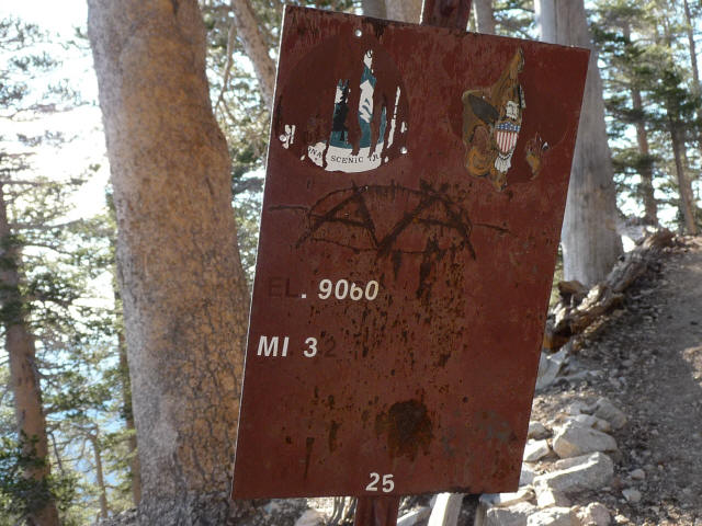
Some seemed to have miles listed to the hundredth, which was very funny since I'm sure there's no way they got that kind of precision. What's more for some reason both Schad and the Tom Harrison map give the trail distance as 3.8 miles! I'm not sure what justification they had for that, but my feeling is that if anything the trail is longer than the stated 4 miles, so I'll stick with that distance for now. I forgot to calibrate my altimeter at the trailhead but instead did it at one of the signs which listed the altitude as 7903. Surprisingly the altimeter stayed quite accurate most of the rest of the day after that.
As the sign sort of shows this trail is a part of the Pacific Crest Trail, so that was a bonus as the PCT carries a special aura for me and I'd still love to hike the whole trail some day. Baden-Powell is the high point of the PCT in Southern California. I'd hiked several other portions of the PCT so it was nice to add this segment. It is a very high-quality trail, one of the best I've been on in California, a little rocky in places but mostly very smooth which some long sections of comfortable dirt. What's more there are trees along much of the trail which provide shade and make it very beautiful and pleasant. One of the best trails I've hiked on.
I thought I should be able to get up in under 1:30 but it took 1:33. So 2.6mph, slower than my pace up the steeper Mount Si, but like I said I think this trail is longer than 4 miles (on the other hand if it's just 3.8 miles then my pace was 2.5mph). Of course I was carrying more weight (my usual 22-25 pounds including 5-6 liters of water and 1 liter of gatorade) and this was higher elevation (Baden-Powell is 8399 feet tall versus 4167 feet for Si), but I also seemed to be taking a more leisurely pace. I was thinking maybe this was my "cool-down" hike before the backpacking trip, and I should just take it easy.
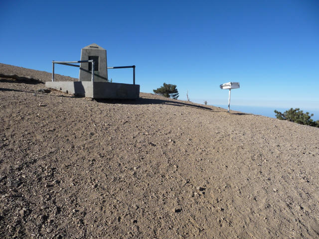
Here's the rather desolate summit. The hinge of the lid of the register box was broken. I signed my name and enjoyed the panoramic view. I took a lot of pictures and some video, but the lighting was better on the way down, so I'll display those pictures later in the report. I thought of eating a little here, but still wasn't hungry, so I just continued on without much of a break.
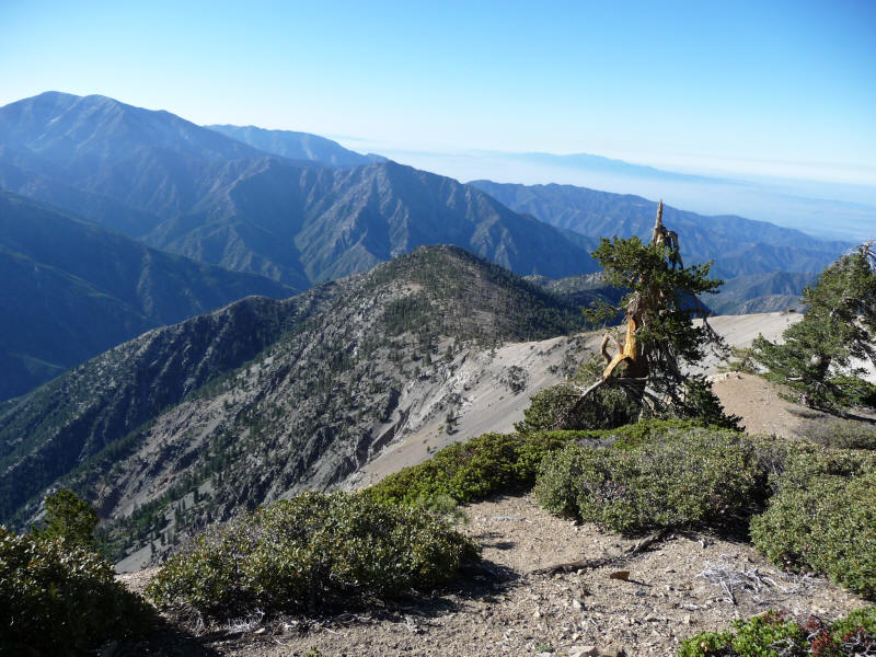
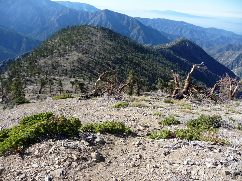
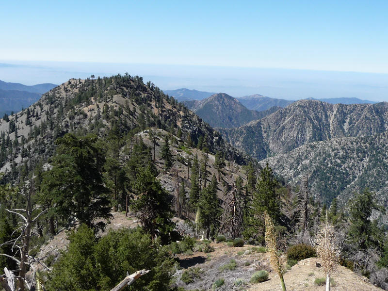
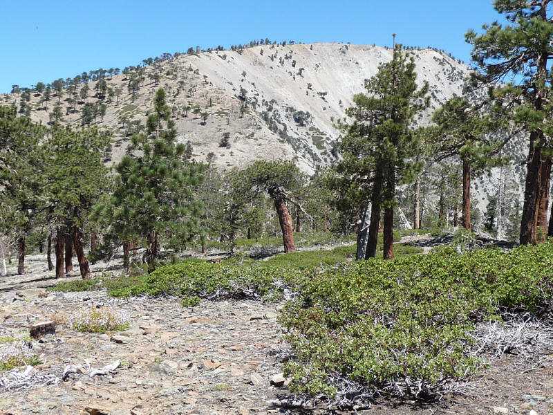
I was eager to see what the ridge leading to Ross was like, and at the beginning it was fantastic. Very dramatic (sadly I didn't take any pictures of the first part, but I suppose it would have been impossible to capture the feeling) and there was actually a trail of sorts so it was easy to follow. The quality of the path seemed a lot better than Schad implied. You could see pretty much the entire ridgeline leading to Ross Mountain so that was fantastic. I was thinking I had stumbled upon a really great hike, and it was sad this would be my last chance to do it for a long time! Here's a picture of the last section of the ridge, leading to the plateau that Schad mentions is a good place to camp. In the background sure enough there's Iron Mountain, and the San Antionio Ridge heading left leading to West Baldy and Baldy. Ross Mountain is to the right blocked by the tree. In the sea of fog rises the Santa Ana mountains capped by Santiago Peak (5687 feet).
A closeup of the plateau and Iron Mountain.
The plateau with Ross Mountain to the right.
The plateau was a lot larger than I expected, and the trail disappeared there, but I guessed where it might lead and was right.
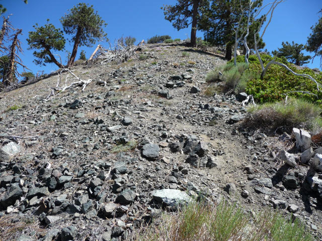
After the plateau the hike went downhill. Now finally were the really steep loose sections, for the most part not as bad as Iron Mountain but there were a couple that were close. It was a lot longer to Ross than it seemed at first, with a lot of intermediate "false summits" except the elevation was going down so I'm not quite sure what to call them. The only good thing was that I figured it would be less painful to climb the loose steep sections than it was to descend them, and indeed it was. Furthermore the worst sections were at the end, which meant on the return trip things get better and better. So not too bad, but not as much fun as I'd hoped. I'd say a hike just to the plateau would be ideal as far as enjoyment goes. But I'm glad I went all the way to Ross this time. Here's the summit register container, which consists of two concentric cans one inside the other, held down by a rock.
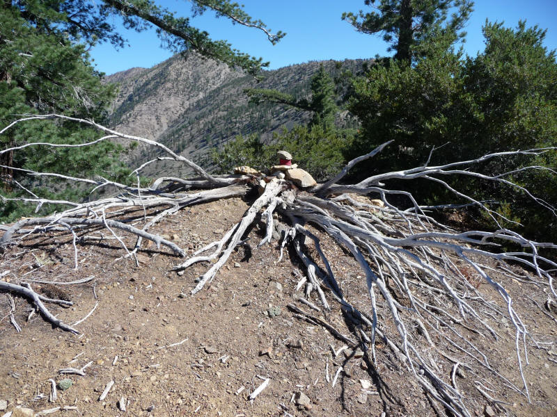
The register itself was a tiny pocket notebook. Impressively it was maybe only a a little over half full, and the entries dated back to 1995! (In contrast the Baden-Powell register went back only a week or two). Schad said only about 12 people climb this peak a year based on when he looked at the register, and at first I thought it was a lot more these days (indeed there were fresh-looking footprints on the trail and the most recent visitor was only 3 days ago) but when I think about it there couldn't have been more than a couple hundred entries over the 13 years, so maybe the average is the same. Schad must have looked at an earlier register though as he said some people wrote their times, whereas I didn't see that in this register, so I didn't include my time either, which at 3:20 was not very impressive. I was pleasantly surprised to see an entry by Bob Burd who had summitted at 7am on June 7. I had just recently joined his Sierra Scrambles Yahoo group. I looked at his web page and found his own trip report. He had started at 4am and so took 3 hours to get to Ross (3 hours had been my goal, but I was slow) and then hiked to a few more summits that day after this hike.
Most people signing the register seemed to be peak baggers and many drew a little mountain with the number in it which is I assume how many peaks they had bagged. They were probably members of the Hundred Peaks Section of the Sierra Club, and indeed Ross Mountain is on the list (which is a lot more than 100 peaks---275 apparently, and I seem to recall some people with numbers close to that).
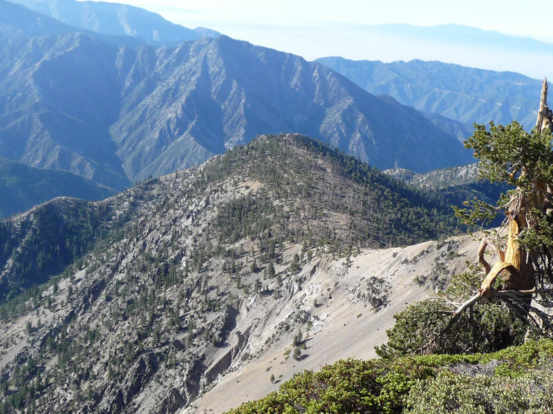
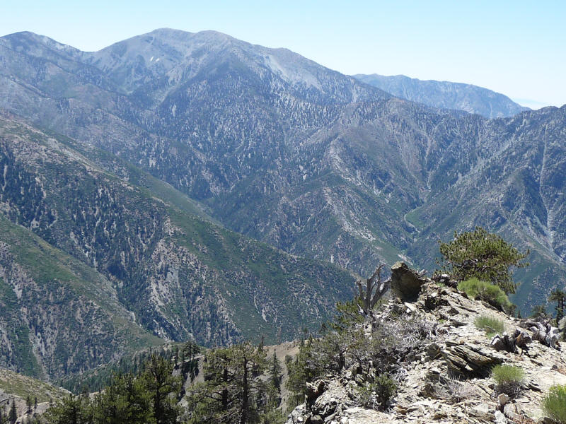
I was feeling a little worn out and didn't go all the way to the southern part of Ross where I could supposedly look down the canyons, but the views near the summit were stunning enough. Here's Baldy near the center with Iron to the right. I stayed on Ross for a half hour, eating a little and enjoying the views. The weather was perfect, about 74 degrees with a very light breeze (it had been windy back on Baden-Powell). It was wonderful to be alone there---well, just me and the flies.

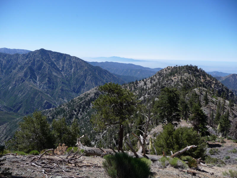
I had finished off the liter of gatorade on the way to the summit and started on the water on the way back. I decided I'd better carry all the water back to Baden-Powell just in case, and then empty some there, but I think I actually did empty out a couple liters earlier, like around the plateau. The hike back up the ridge was indeed more pleasant than going down it. It was warm with the sun high in the sky and no shade, and I was going slowly, but it was just a measured trudge and not too bad. Here's a view back up the ridge first to the plateau and then Baden-Powell in the background.
A look back down to Ross with Iron to the left and the Santa Anas in the distance.
Ross again. To its right is I think Rattlesnake Peak (5826 feet).
Here's a picture of one of the steeper sections. Of course it doesn't look as steep in the picture as it was, but you can get an idea if you pay close attention to the direction the trees are growing in.
A great view of Baldy.
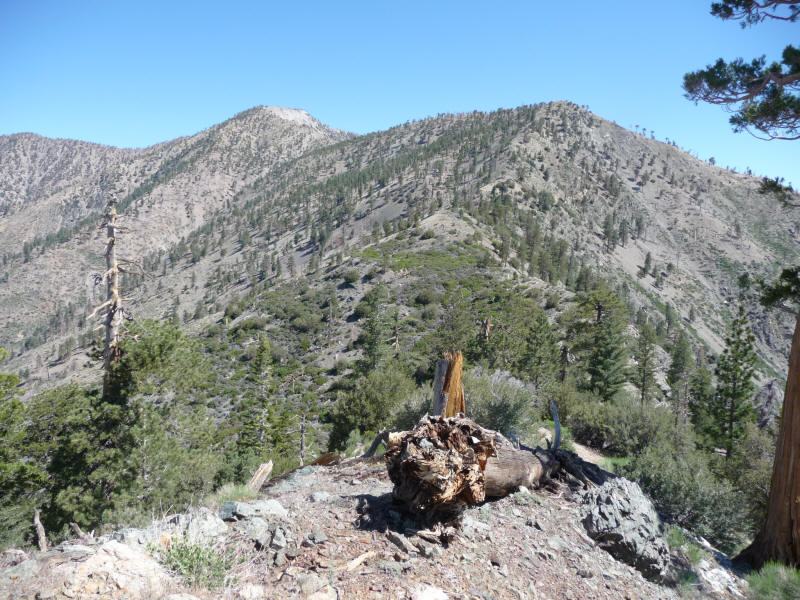
Finally reaching the plateau with the last ridge to Baden-Powell visible.
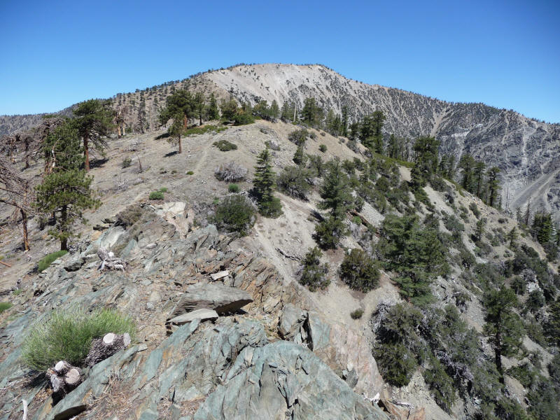
The final ridge seen from the plateau.
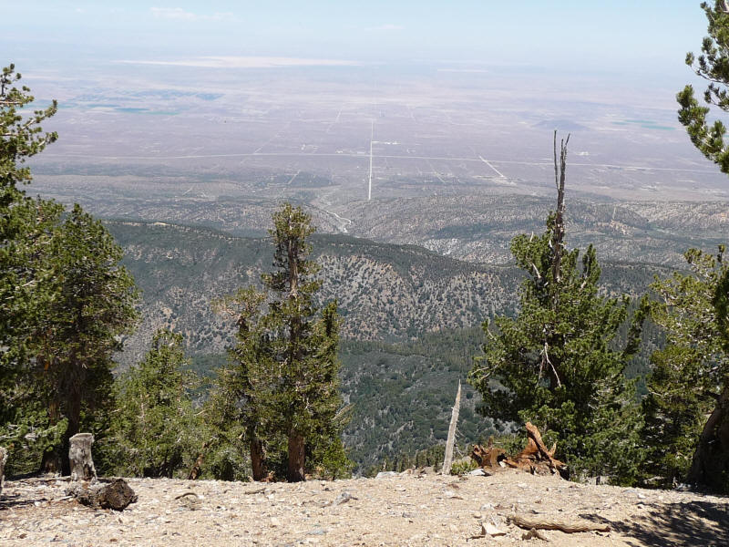
I made it back to Baden-Powell in 2:13, quite slow, and took some more pictures from the summit. It was especially clear toward the desert and you could see the Tehachapi Mountains very clearly. Here's a view into the desert that also shows the transition of plant life---really interesting.
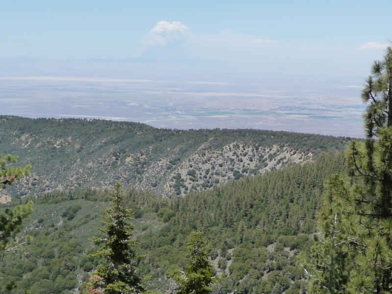
Although it didn't come out so well in this picture (zoomed in) I could also clearly see a huge plume of smoke from a forest fire. This is most likely the Piute Fire near Isabella Lake although it's possible it's the Clover Fire near Olancha.
On the summit I got rid of all but two liters of water, which was still a lot but I thought better to be safe. After enjoying the view one last time I headed down the trail back to Vincent Gap. Since it's so high quality it was easy to jog down, but I was also a lot more tired than I expected and slowed to a walk for much of it. I noticed something going down that I hadn't noticed going up: all sorts of use trails cutting the switchbacks! Many were so well used that they were just as high quality as the original trail. I can understand cutting the switchbacks but many of them were way too flat and long. I took a couple of the shortcuts that were well-developed and not steep, but skipped almost all of them and just followed the trail.
At one point I reached for my water bottle only to find it not there! It must have fallen out of the pocket at some point down the trail. I don't recall hearing anything fall, though. Another possibility is that I simply forgot to put it back in the pocket when I was on the summit, but that seems less likely. I used to clip the loop holding the cap onto the nalgene bottle onto a backpack strap using a mini carabiner precisely so it wouldn't fall or (or more likely be pried out by a twig or somesuch) but that makes it a pain to get the bottle out and this trail was so straightforward I thought I didn't need to do that. It was a good thing I still had my extra liter inside the pack, although as I was so close to the end it really wouldn't have mattered. I felt less bad about losing my bottle and water than I did about littering the mountain, and although I feel bad for making someone carry my bottle out I hope someone did find it and take it back to the trailhead. It's yours if you found it, and I hope you get good use out of it!
I thought I should get down in 45 minutes (6mph) or at the very worst an hour (4mph, my normal walking pace) but it took 83 minutes, for a miserable 2.9mph! I did stop for a few minutes, for example to look for my water bottle, but if you say it took 78 minutes then that's still only 3mph. Even though I was going slower than I should have I still feel like I must have been going around 4mph. So that's one reason I think the trail must be longer than 4 miles, but a better explanation might be that I was more tired than I thought. Still the trail did seem to go on forever, with extremely long sections between the switchbacks. I wonder if anyone has tried to measure the length accurately.
I thought this hike would be easier than Baldy via the Baldy Trail but it felt harder, particularly due to the steep loose sections along the ridge. I was worried doing this hike would do more harm than good, but despite feeling tired at the end I was otherwise fine, and not sore at all afterwards.
I managed to get cell phone coverage in Wrightwood, and used probably my last chance to talk on the phone while driving before it becomes illegal July 1. I called Lydia at about 1:40pm, waking her up (she'd gone to bed at 4am) and told her I'd be there in an hour. Unfortunately Roz, having not been informed that we were meeting so late, had already eaten lunch and didn't join us. So this was the third time David, Lydia and I ate together in a week. Sadly our last for probably a long time. I was thinking of just going back to Shinsengumi, but David and Lydia suggested a Chinese noodle place nearby in Temple City whose named is Happy Noodle. This was a great choice. I was going to just let the two of them order as usual but noticed hong you chao shou (dumplings in hot oil), one of my favorite dishes, on the menu, so I insisted we order that. Surprisingly Lydia and David had never tried it before. It was my favorite dish at Joy in the Bay Area, and I'd been hoping to try it down in LA but no place I'd been to had had it on the menu. Finally I'd have a chance! It wasn't nearly as good as at Joy, sadly, but I still really enjoyed it.
The noodles themselves weren't that great, certainly nothing compared to ramen, but the steam buns were very good. The surprise of the day, however, was a simple dish called liang tiao huang gua (cold mixed cucumber), which amazingly I'd never had before. Lydia had ordered it since it would be refreshing on a hot day (it was in the high 90s in the valley) and did it ever taste incredible, one of the best things I've ever had! We ordered two dishes, in fact, and had no trouble finishing it off. It's just cucumber with sesame oil, garlic, onions, salt and sugar (Lydia also added vinegar to half of it, and it tasted great with or without) and I guess it must be because those are all among my favorite flavors that it was so awesome. A great last meal for my last LA hike before I move.
Distance from trailhead to Baden-Powell Summit: 4 miles
Baden-Powell to Ross: 2.8 miles
Total distance: 13.8 miles
Elevation gain: 5500+ feet
Time trailhead to Baden-Powell: 1:33 (6:19am to 7:52am)
Baden-Powell to Ross: 1:47 (7:52am to 9:39am)
Total time to Ross: 3:20
Atop Ross: 0:30 (9:39am to 10:09am)
Ross to Baden-Powell: 2:13 (10:09am to 12:22pm)
Baden-Powell to trailhead: 1:13 (12:22pm to 1:35pm)
Total time back: 3:26
Total time: 7:16