I'm not sure just why it took me so long to try hiking up Mount Whitney. One factor must have been that it's a very long drive from the Bay Area, but after I'd moved down to LA that was no longer a point--in fact from LA it's one of the easiest Sierra mountains to get to! Worries about altitude were certainly a factor, as well as the 22 mile hike which sounded like it would be a long trudge and not very interesting (was I ever wrong about that). Also it just seemed too popular, and even when I figured out it wasn't too hard to get a day permit I was still too lazy to actually go and do the hike. And most of all from what I read and heard I somehow had the impression that Whitney itself just wasn't that interesting a mountain--that it's only real claim to fame was that it was the highest peak in the US outside Alaska, but otherwise other mountains like Longs Peak or Mount Rainier were somehow better. Again I was completely wrong about that. However in any case after hiking up Fujisan earlier in the summer and realizing I hadn't even been to the highest point in my own state, I knew it was time to finally climb Whitney.
Since I was going to Colorado to climb some 14ers this summer, it seemed logical to do Whitney soon after, giving myself some time to rest, but not too much time since I was hoping to save some acclimatization. I have no idea still how long acclimatization lasts before it wears off, but I ended up doing Whitney eight days after Quandary Peak and didn't have any altitude problems. I'm sure it also helped a lot that I slept in Tuolumne Meadows (about 8700 feet) two nights before Whitney, and also climbed a bit there for parts of two days before Whitney. I did sleep in Lone Pine (3700 feet) the night before. I was considering camping at Whitney Portal (around 8000 feet) the night before, but decided after two nights of camping I wanted the relative luxury of a motel room before the hike. I was quite worried I wouldn't be able to make it, and wanted to do everything possible to help my chances.
My main worry was the combination of length, climbing and altitude. Mount Whitney is apparently 14,505 feet according to the latest measurement (see this Wikipedia article), and the trail is 22 miles out-and-back with a net elevation gain of 6130 feet (but also some descent in the middle, so there is more overall climbing).
The longest hike I'd done to this point was North Dome in Yosemite which was about 21 miles, but with only 5000 feet or so of climbing and at considerably lower altitude. I'd done it several years ago (around 2000?) and remember being absolutely exhausted when I was done. The longest I've walked in a single day was about 27 miles, to and from work my last day at Siebel four years ago, but that was all on flat sidewalks at sea level and with a big break for the work day (actually I spent all day saying goodbye to people) in between. I'd also done a 19 mile day in the middle of two 15 mile days in the High Sierra Camp Loop, but again lower elevation and less climbing. More recently my longest hike was San Gorgonio at about 17 miles (gaining 5400 feet--it's a typical training hike for Whitney), and my feet were quite sore after that. Still, just 5 more miles...it doesn't seem like much alone, but after 17 miles I was sure it would seem like a lot.
As with anything new there's a lot of doubt about whether I can do it or not, but again I did what I could to increase my chances. I hiked and bicycled a lot this summer, and so was in pretty decent shape. The Colorado trip got me used to altitude, and spending a few days in Yosemite right before was sure to help. The weather seemed like it would likely not be too bad. I was fairly confident things would go well.
I was thinking of perhaps climbing the Mountaineers Route up and taking the trail down, which would make for a shorter and seemingly much more interesting (although harder and potentially dangerous) ascent, but although I read up a lot on the approach I wanted to go with someone who had already done it and knew what they were doing, since I felt I could easily get lost on the approach or perhaps run into snow on the climbing portion and not know what to do. I recalled my thesis advisor's wife, who is a very serious hiker, having done much harder hikes than Whitney, either having done the Mountaineers Route before or wanting to try it. However she had injured her hip recently and wasn't able to hike, so having to go alone I decided it would be prudent to take the trail both ways and save the Mountaineers Route for the future.
I originally planned to do the hike on the 20th, since Wednesday tends to be the least popular day for hikes. There were still plenty of day hike permits available. However when Cindy Chiu planned out our trip to Yosemite it seemed Tuesday the 19th was the better day. Fortunately there were still plenty of permits for that day as well (in fact when I got home there were still 48 (out of 100) available day hike permits listed on the website), and although I could have saved myself the $15 reservation fee by just trying to pick up a permit the day before, I decided it was worth the money to ensure I could hike when I planned. I didn't reserve early enough to get the permit in the mail, so I had to make sure to leave Tuolumne early enough to get to Lone Pine by 6pm to pick up my permit, or else make arrangements to get it after hours. When I got the mail later after doing the hike I realized they don't send you the permit anyway and you still need to pick it up in person, so it didn't matter.
I first drove to Yosemite, and the report of that trip should ideally be read before this one. Then at about 1:30pm on the 18th I left my friends at Pothole Dome and drove over Tioga Pass. This was my second time down this road, the first time being on bicycle. The scenery going down was even more spectacular than I remembered. Certainly one of the most beautiful roads I've ever been on. I first drove to Bishop, which was something of a shock because 395 had been practically devoid of cars, but Bishop was jammed with them. Where did they all come from? I wanted to get gas but every station (and there were many) was filled with cars waiting for the pumps. Finally at the south end I found a Shell station which wasn't too crowded. It was good to get gas in Bishop because the towns further south were even more expensive. I also had lunch at McDonalds (a Big Mac and small Hi-C orange, which after drinking mostly water the previous couple days tasted extremely good). Finally I wanted to stop by Wilson's Eastside Sports, a fairly famous mountain sports shop, but it took me a little while to find it even though I had the rough location written down from their website. I'd forgotten to bring a couple key items for the Whitney hike--even though I'd gone through a checklist I somehow convinced myself I had packed them when I hadn't. I need to be more systematic about packing in the future. One was a baseball-type cap to keep out the sun, and the other was a rain jacket. Neither was essential, perhaps, but the latter was particularly worrisome. I could try to go without it and hope it didn't rain (rain wasn't in the forecast) but such a jacket is also an important part of my layering for cold. Otherwise I'd just have my technical tee-shirt and fleece, plus perhaps long underwear. I thought I should at least get a cheap plastic raincoat.
I ended up visiting the Tuolumne Mountain Shop Monday morning while my friends were still lounging about camp. By good luck they had a 30% off sale on winter gear (rain jackets counted), probably as they are closing for the season fairly soon. I found a nice Sierra Designs Hurricane parka marked down from $55 to $38. It didn't look nearly as breathable as my GoreTex rain jacket, but it was much cheaper and also lighter and smaller, so it seemed like a good complement to my other jacket. I also picked up some Black Diamond Jetstream gloves. I had considered bringing my ski gloves but thought they were too bulky and it would be unlikely it would be cold enough that I'd need them. Still I was going to use my trekking poles and so my hands would be exposed and just in case it was cold it seemed like a good idea to have some lightweight gloves. Both of these turned out to be ideal purchases. I also bought a Yosemite baseball cap at the grocery store next door--red colored and so a bit gaudy but it was the only one I liked and also the cheapest at $13. This was the one item I ended up not using!
It was good I got the rain jacket and gloves in Tuolumne, since the best jacket for my needs I saw at Wilson's was also the Hurricane and it was full price. I was hoping they'd have some Arc'Teryx climbing harnesses because I want to get a new harness and no one seems to carry Arc'Teryx (a favorite maker of mine) harnesses around LA. But Wilson's didn't have them either. Still it was a big and very nice store. They had some mountaineering boots (La Sportiva Trango S EVO GTX) that I wanted for $250, far less than the $285 REI charges, so I was tempted but didn't want to buy them right then.
After more driving, some through very beautiful country (I hadn't been on this part of 395 before, having only been on the section between Lee Vining and Reno, and having briefly crossed it while traveling on 178 through Inyokern, on previous bicycle trips), I arrived in Lone Pine. I need to both get my wilderness permit at the station south of the town, and to find a motel room. There seemed to be plenty of motels so I got the permit, which was my main worry, first, but I should have gotten the motel first! At the permit office there was a large noisy group of middle-aged men getting their permits. After I got my permit I wandering around a bit looking at books, and could hear the leader of the group suggesting they do the Mountaineers Route to save a lot of distance (taking the trail back). He was saying only the chute was third-class, and the rest was first-class and would be no problem. From what I'd read that was not the case. I was very curious if I'd meet this group the next day. The ranger said the weather for the next day looked very good except for strong winds. No thunderstorms in the forecast so that was a big relief. Still I wanted to be off the summit as early as possible.
Back in Lone Pine I tried to find a motel that looked inexpensive but decent. The first place I tried just gave their last room to the guy in front of me. Other places were either full or one place had only huge rooms with four beds left for $125 a night. The nicer hotels, the Best Western and Comfort Inn, both a mile or two south of the main city, had "No Vacancy" signs taped on their windows. I started to get desperate. I certainly didn't want to drive back to Independence and try my luck there. I could possibly try camping after all at Whitney Portal, but given all these places were full it seemed likely the campground would be as well, and I didn't want to have to drive 13 miles up a winding road gaining 4300 feet of elevation to find out. I was amazed that Lone Pine could be so crowded on a Monday night in late September. I wished I'd tried earlier, as I probably wouldn't have had any trouble just an hour before. Every motel seemed to swarm with last-minute people trying to find a room. Finally one place suggested I try the Timberline Motel which was a block off the main street and so perhaps easier to get a room at. The Timberline did indeed have a room, although with 2 beds and $92 including tax. I forget how much our motel rooms typically cost on our bike journeys, but this seemed high. Still I didn't care at that point. I paid and took the room, which was at least non-smoking. I ended up leaving my sunglasses, which I've nearly lost many times including the recent Japan trip, on the counter, but the woman was nice enough to find me and return them. The room itself was fine--quite clean and decent. It had air conditioning and a refridgerator, both of which were very noisy but at least working. I set off to eat a small dinner and get some food for the next day. I was still not very hungry after the big meal the previous night in Tuolumne, although that was a little worrisome since I felt I'd need a lot of food to keep my energy up for the long hike. I ended up eating at the only fast-food restaurant in town, McDonalds, although I had a chicken sandwich to distinguish the meal from lunch. I again drank the Hi-C orange, refilling twice and bringing the last one home to put in the refridgerator and drink for breakfast.
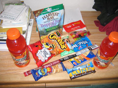
I found a supermarket but had a lot of trouble finding good food to bring along. I ended up with this:
It's interesting to compare it with what I brought to climb Fujisan. The two half-liter bottles of Gatorade I put in the refridgerator and combined into a one-liter Nalgene bottle, then filled the other two Nalgene bottles with tap water from the bathroom sink. I only brought three liters of drinks which I was very worried would not be enough--I've done shorter hikes in hot weather and three liters was just barely enough. But there were places to get water along the way so I figured if I ran out I'd be okay. As it would turn out, the refridgerator wasn't that useful because by the time I took my last sips of Gatorade near the summit the drinks were already much colder than they were coming out of the fridge! I drank all of the Gatorade but almost none of the water I brought, so just slightly over a liter drunk for 22 miles and 13.5 hours. I did drink maybe a half liter of Hi-C before leaving. Still although I worry I'm drinking too little on cold hikes, I didn't feel I needed to drink more. At the end of the hike I drank just a little more, and when I got home some four hours later I wasn't particularly thirsty either.
As far as food goes I ate the Luna Bar (my first ever--okay but not great)
and half the Cheetos (for some reason I was in the mood!) for breakfast.
During the hike I finished off the Cheetos, cashews, and beef stick, ate half
the Mike and Ike and 2/3 of the crackers, and just a little of the dried fruit
which wasn't very good. I didn't touch the jelly beans or Cliff Bar.
This was again fine as far as amount of food goes. I did find when I
weighed myself that night that I was only 136 pounds, though! Before the
trip I was probably 140-142.
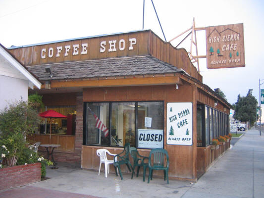
I wandered around town a little which was fun. I thought this place might
be good if I wanted a really early breakfast, but on closer inspection it was
more amusing than useful.
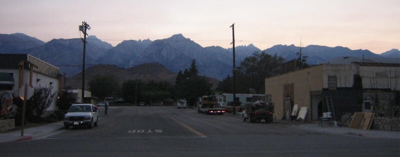
It was already getting dark, but I could still make out the mountains. It was cool to see Mt. Whitney, which I would be climbing the next day, from Lone Pine.
I went back to motel and took a shower which felt great. I then got all my stuff organized. I planned to get up at 3am and then would start hiking around 3:30 or 4 depending on how long it took to get to Whitney Portal. I didn't want to start too early since I didn't relish hiking in the dark for a long time, and that seemed like a good compromise. However after getting to bed at 8 or 9pm the last two nights, I found I couldn't sleep this one! One reason perhaps is that I slept rather late that morning--until about 7am--but I think the main reason was the excitement and anxiety of the hike the next day. I ended up staying awake until at least 10pm and was able to see the season premieres of How I Met Your Mother and Two and a Half Men on TV. But even then I could hardly sleep. By around 1am, having slept an hour or two at most, I decided to just give up. I felt wide awake and fine, so my only worry was that I'd fall asleep during the hike! Since it was still too early I took my time eating breakfast and getting going, and left between 1:30 and 2am. After a slow dark drive up to Whitney Portal I first tried to find the trailhead but gave up and just parked. I thought the trailhead was near the store, but couldn't find it. There were a few other people who had just arrived and I asked one guy if he knew where the trailhead was, but it turned out he didn't speak English well. I got him to figure out what I was asking, and he tried to show me where the trailhead was, quite near to our cars (which I was sure was not close to the trailhead) and considerably east of the store, but he couldn't find it either. I was surprised they would make the trailhead so hard to find especially since most people start in the dark! I had thought there would be big signs at the beginning. A woman who was with the man came and she spoke considerably better English. She said I could hike with them if I liked; they were putting their food in the bear lockers now. I declined as I preferred to hike alone, especially at the beginning where I tend to stop a lot to adjust things until I'm comfortable. So I set off to look again near the store, but I couldn't find anything. I wasn't sure if I should look further west or go back east, but then the woman came up and said they'd found the trailhead. It was back where the guy thought it was, very close to my car indeed. I thanked them but as they were still not ready I started off alone.
The trailhead sign is just a small wooden one which somehow I didn't notice in my car's headlights. However just a little farther along are all the information signs arranged as a sort of tunnel. I started at 2:30am. It felt great to finally be hiking. The temperature was not too bad and I don't think I even needed the rain jacket or gloves at first, but I figured it's always most cold just before dawn. I don't like night hiking much since you can't see anything, but unlike Longs where you hike through a forest to start with on Whitney the trees are reasonably sparse at the start and you have a lot of views of the sky. The stars were beautiful and the experience quite enjoyable--by far the best night hiking I've yet done. You have to cross several streams early on, which were not hard but a bit spooky in the dark. I was surprised how strong the streams were running so late in the summer, but then we did have a lot of rain late in the spring this year. I started out using my trekking poles, which I haven't used in a year or two, but I thought they would be helpful to take some weight off my feet for the long hike. They were useful for the stream crossings too. But I found them to be more of a hindrance than a help, and sometime after sunrise I collapsed them and attached them to my backpack, never to use them again. So they ended up putting more weight on my feet instead of less! On top of that since I didn't drink much water I still had two liters I was carrying at the end of the hike. Well, I wanted to practice carrying more weight on hikes and I guess this is a start....
At 3:43 I came across a junction to a side trail leading to Lone Pine Lake. I pulled out my map to see where I was, and a woman came out of the darkness and asked if I was checking the location. I thought at first it was the same woman who told me where the trailhead was (their group seemed a little behind me, more or less keeping my pace), and I wondered why she wasn't with her companions. But it turned out to be someone else entirely, a woman named Michelle Totman (as I would learn later) who had set off at 2:15am, but took the Lone Pine Lake side trail by mistake and then returned when she realized she was losing too much elevation. We walked together for a little bit and I learned she was a junior at UC Davis, grew up in San Jose, and wanted to go into management at a national forest office. Our hiking paces were pretty much identical which was great. However at some point I had to stop to pee and she hiked on. I had to stop to pee many many times during the hike, which always happens during cold hikes and which is always a pain. It was fine in the dark but the Whitney Trail is very exposed so it was tougher during the day. Fortunately thanks to the quotas there aren't many people around.
Not too long after Michelle went ahead I got confused about where the trail should go. The trail for the most part is extremely easy to follow, which is a great help when you are doing so much of it in the dark. Indeed Michelle said she practiced doing a lot of night hiking before doing Whitney, but found Whitney was the easiest of all the trails she tried! And she must have had no trouble at the spot I was at, because she was nowhere to be seen. Fortunately soon after the group behind me caught up. I would learn later that the man and woman I'd spoken with before were Spanish, and there was another Austrian woman with them. I don't know if they knew each other from before or not, but they stuck together the whole hike. I decided to follow them and they started by going the exact wrong way I had! But then they backtracked and found the right trail. So I just stuck with them, keeping a reasonable distance, which helped with staying on the trail. They went at a good pace and never seemed to stop at all. After a bit I started to get quite cold and stopped to put on my rain jacket, gloves and wool hat. I caught up with them and then they stopped to put on warmer clothes. They later got ahead of me. After it got light enough to see the trail without a headlamp I ran into Michelle, who was stopped eating some food. As I hadn't eaten anything since my small breakfast I was hungry as well and stopped to eat with her. We ended up staying together the rest of the hike.
I had intended to just do the whole hike on my own as I usually do, but it was enormously more enjoyable having company. Our paces were nearly identical, and we took turns leading. Even when one of us would stop the other had the same thought in mind! It was really interesting to talk with her as well. Like me she also loves rocks and trees, but unlike me she's actually seriously studied them so she was able to teach me quite a few things. She had some great summer jobs, working summer last year in Lassen National Forest and this summer at Teakettle Experimental Forest. While at the former job she'd had the chance to climb Lassen Peak, and was immediately addicted to mountain climbing (as happened to me the first time I climbed Half Dome). She was in the middle of an outdoors road trip with her father (I hope Kyle wants to do similar things with me someday!), who unfortunately couldn't hike himself due to a knee injury. She in fact had her own knee injury--she'd sprained her knee a month or two before and was wearing a brace. It got to be painful near the end of the hike, but although I offered her many times to use my hiking poles she declined, and she was fine. Unlike me she'd done plenty of long hikes--typically 25 miles--but fairly flat ones. She'd never been at such elevation before, though. To prepare for this hike she did Half Dome just a week or so earlier, and also spent some time at 12,000 feet I think. She ended up having no altitude problems either.
Not only did we talk with each other but we ended up talking with a lot of other people on the trail as well. I was surprised how social a hike Whitney is. I think it's because of the quota system--somehow the number of hikers on the trail is just right. Everyone we met was extremely nice. Some were really into mountain climbing as well so we heard a bit about climbing Kilimanjaro from one guy and about climbing volcanoes in the Cascades (including Rainier and Shasta) from another. A lot of guys we ran into were part of a 14 man group that started out together but got dispersed into a lot of little groups. I didn't realized until near the end of the day, when we hiked for a while with one guy in the group, that this group was exactly the one I'd seen at the permit office! Partly it was my terrible memory for faces and partly it was because I didn't expect them to be going up the trail. They'd decided not to use the Mountaineers Route after all, surely a wise choice. They were from Santa Barbara, and were apparently quite wealthy--some of the group had flown in in two private jets piloted by two of them. However I never would have guessed that by just talking to them--they were just ordinary very friendly guys having a fun time on Whitney.
Another group we ran across was three guys carrying ropes and climbing gear down the switchbacks. It turns out they'd just climbed the East Buttress, a classic technical route (5.7), and had done it in the dark! They said they summited at something like 3:45am, but they didn't say when they started. There wasn't much if any moonlight that night either. I'd love to climb the East Buttress someday, but during the day with plenty of light....
One person we never did see all day was a ranger! I thought there would be some checking permits since this is such a highly regulated hike, so it was a little disappointing in a way. We did see some people in the Whitney Zone without tags on their backpacks, but it wasn't clear if they just didn't bother to attach the tags or if they were sneaking in. As there were so many day hike permits still available that day it probably didn't matter.
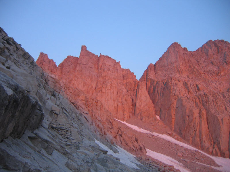
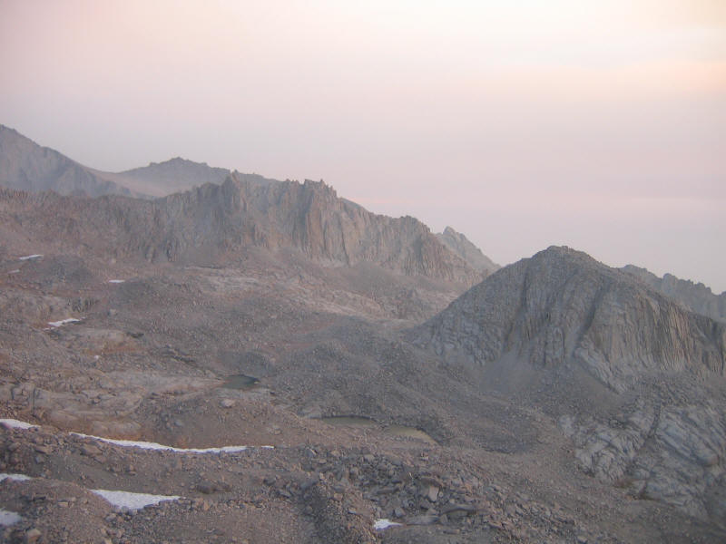
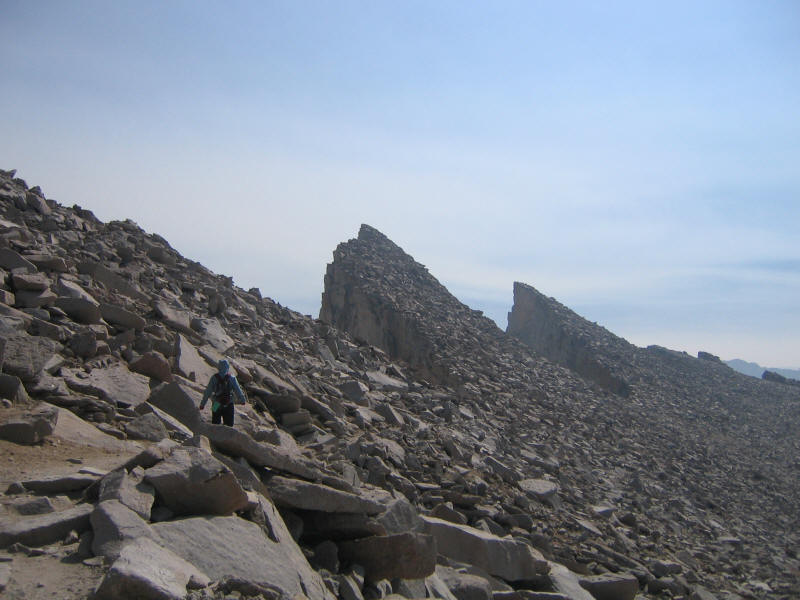
I think my watch read 5:57 when it was light enough to see the trail without my headlamp. Apparently civil twilight was 6:12am and sunrise was 6:38am. It must have been a little after 6am that I ran into Michelle the second time, and we were somewhere in the famous "96 switchbacks" section leading up to Trail Crest (13,480 feet) at which you move from the east to the west side of the mountain. I don't know if 96 is an accurate number or not. Supposedly one guy that day counted and got 104. Anyway they do seem endless, but they're not bad. As soon as the sun started to rise, Michelle and I stopped and started taking a lot of pictures. After over 3.5 hours of hiking in the dark we could finally see where we were, and we were amazed how beautiful it was. My earliest pictures didn't come out well due to the poor light, but plenty of them came out beautifully and it was tough to just pick a couple. Here's one I particularly love with the contrast between where the sun hits and doesn't:
Here's a look down at what we passed. The mound to the right is called Wotans Throne, especially appropriate as I'm about to see Wagner's Ring performed in Orange County in early October.
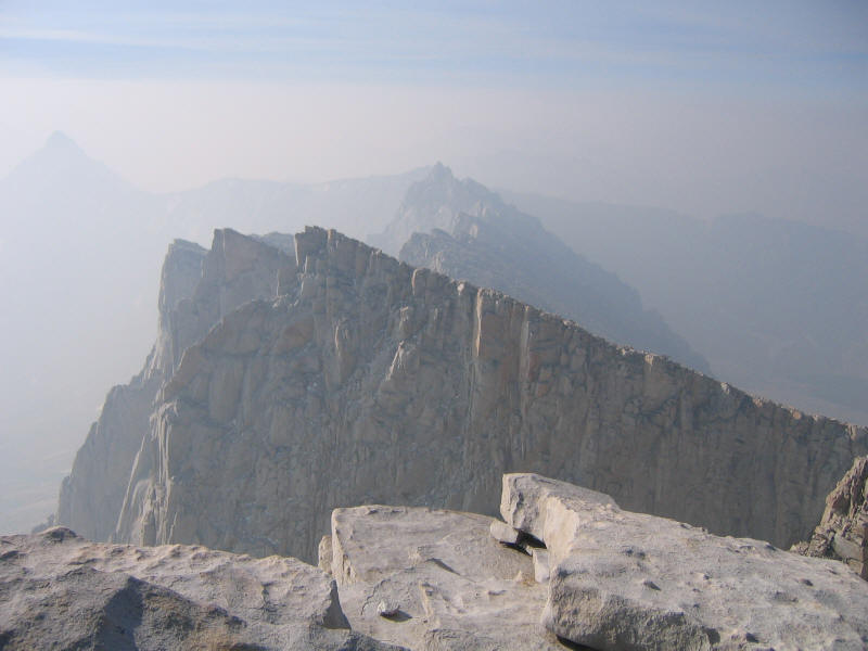
And here's a shot showing the summit of Whitney itself. The puzzle is: Which one is it? We had a lot of trouble figuring this out ourselves. Here are a couple hints. The highest-looking thing in the picture is not Whitney, but rather Mount Muir (14,015 feet). Also the hut near the summit (in a picture below) is faintly visible in this picture.
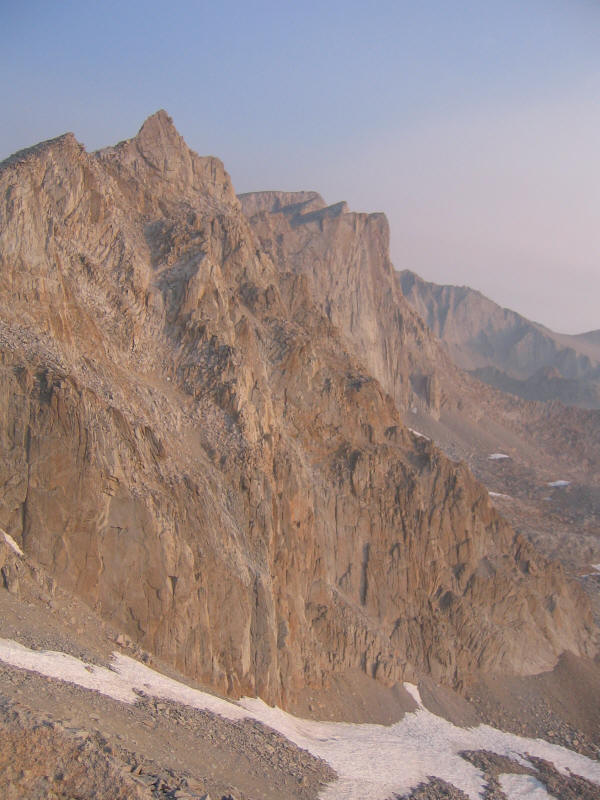
I completely forgot about Mt. Muir, which I'd read about before and was thinking of climbing as a short side-scramble (3rd class) from the trail. I could have ticked off another of California's fifteen 14ers! I don't think it would count as a 14er under the Colorado rule that a peak has to rise at least 300 feet from the connecting saddle, but this is California and it does seem to be one of the recognized peaks. Anyway not too sad that I forgot about it, because it gives me a good excuse to come back! Even without it I would love to climb Whitney again.
I thought that once the sun came out it would get warmer, but in fact it continued to get colder and windier. It seemed like elevation was beating the normal daytime warmup. One nice thing about the wind though was that it always seemed to be at my back! I was very glad I had my rain jacket and gloves, and felt bad for Michelle who had no gloves but she got along by keeping her hands in her coat sleeves and holding the ends shut. We made it to Trail Crest and the other side, but didn't take many pictures here since it was so cold. The winds were quite strong as the ranger had warned. Still this being California the sky was clear blue. Unfortunately there was a lot of smoke, apparently from some fire, which hurt the views but also made the scenery look cooler in a way. Michelle said someone who climbed Whitney earlier had reported it was 60 degrees the entire day. I think someone else mentioned that even the day before the weather was much warmer. Of all the things I worried about Whitney, somehow cold and wind were not among them. If anything I was worried more about heat! In a way it was too bad the weather wasn't nicer, but in a way it felt more like climbing a real mountain to suffer a bit, and I think it made everyone doing it that day feel a little closer to each other.
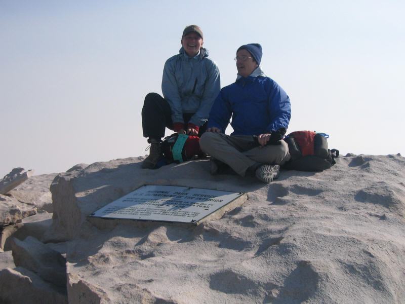
When the sun was really out I put on some sunblock, just on my face, neck and backs of my heads, the only areas exposed during the whole hike. I'd stupidly brought along both a big container of sunblock (for Yosemite) and a little one (for this hike), forgetting that I couldn't leave the big one in the car due to bears. I guess I could have left it in the bear locker, but I just carried it with me, so more weight. We slowed down quite a bit as we got higher, and near the summit were passed by a guy quite a bit older than me who was going strong and had left a good hour after me. So that was impressive. Finally we made it to the summit at 9:20am, and despite the cold and wind of course had to get our pictures taken. One guy, I think from the big group of 14, took a couple pictures of Michelle and me with my camera and with hers. Below is believe it or not the better of the two I got. I'm not sure why I was looking the wrong way.
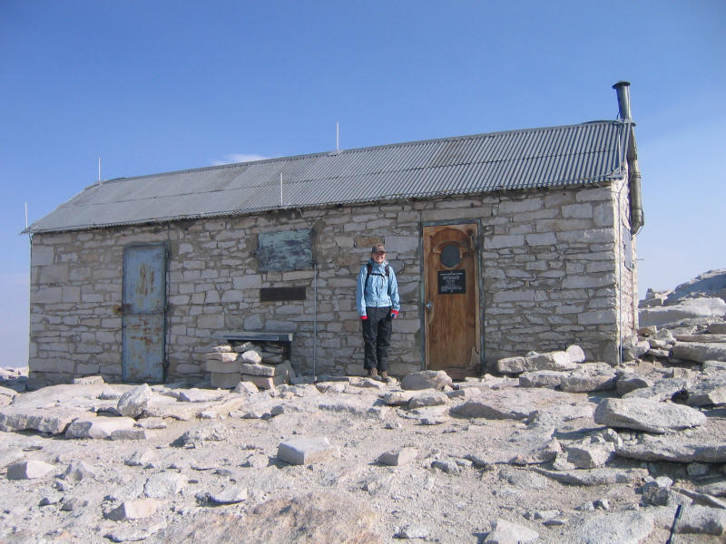
Here Michelle in front of the Mt. Whitney Hut. For some reason only the right half is open; we don't know what's in the left half but guessed it was emergency equipment. We went inside to warm up and eat some food, and were joined by quite a few other guys, mostly (entirely?) members of the 14 man group. It was nice to chat while we shivered and tried to warm up. I later read that there's supposed to be a summit register in the hut, but I didn't notice it and I don't think anyone else at the time did either. So yet another summit register I've failed to sign!
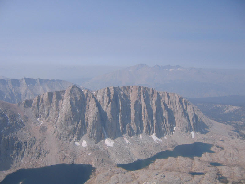
Here is a view of the Needles from the summit. Again the smoke from the valley makes it seem even more unreal. I couldn't believe how beautiful the Whitney area was. I'd seen pictures before but they (including my own) don't even come close to doing it justice. I think it may even surpass Yosemite as the most beautiful place I've been. I love rocks and the whole place was this incredible "wonderland of rocks" to borrow the name of an area of Joshua Tree. Cindy Chiu called Joshua Tree a playground for adults, a phrase I love, and Whitney seemed to dwarf Joshua Tree in magnificence. I could imagine coming here a lot and climbing and exploring all sorts of things. Even though I was there for over 8 hours in the daylight, somehow it was just all too much to really appreciate. What's more the Whitney area has to be the most alien-looking place I've ever been. I don't feel a need to visit another planet--this area already seems like being on another planet. This trip made me want to explore the High Sierra even more.
Here is the the backs of those same Needles.
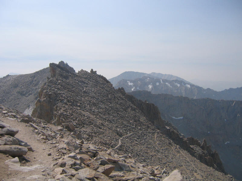
The John Muir Trail zigzags down on the back side.
Mount Hitchcock (13,184 feet) and the Hitchcock Lakes.
We crossed back to the east side, and things got warmer and less windy as we got lower and the day progressed. We were finally able to see all the scenery we'd walked through in the dark, and it was also stunning. Here is the view down the canyon as we return. You can just barely make out the outline of the top of the Inyo Mountains (which we incorrectly thought were the White Mountains, actually further north) through the smoke.

We took our time returning, stopping to talk with people along the way (many backpackers were heading toward Trail Camp in the afternoon), looking at trees, and just enjoying the day. We ran into the Spanish/Austrian trio again near the bottom. I thought they'd passed me long ago, but they said they took a nap in the summit hut. They turned off onto the Lone Pine Lake side trail to visit the lake (they said they'd take a swim but I kind of doubt they did....). Looking at the map later this side trail looks very short, so that's another thing to do the next time I visit.
I had no idea how long it would take to do this hike. At 2mph it would have taken 11 hours, but that seemed unrealistic so at random I guessed 12 hours. I could probably do that or maybe even 11 hours or less if I were in better shape and hurried, but there was no hurry this day and the 13.5 hours it took seemed just fine. Surprisingly my feet felt less sore than they did after the shorter San Gorgonio hike, and I was not tired at all, probably due to being so excited about how terrific the hike was. My knees didn't hurt at all, not a surprise as the trail is very high quality and not very steep.
We got back to the trailhead just after 4pm and said goodbye. Michelle would wait for her father to pick her up at 6pm, and I would head home right away. Although I didn't feel tired I was worried that the excitement would wear off and I'd get very sleepy, but luckily that didn't happen. I left around 4:45 and after just over 3.5 hours of driving (and this was mostly at slow speeds since I certainly didn't want to get another ticket) I made it home a little after 8pm. Despite having hiked for 13.5 hours after less than 2 hours sleep I still felt fine and went to bed normally, immediately back to my normal sleep schedule.
Although the hike is long, it's extremely enjoyable and the stunning scenery makes it one of the best I've done. I'd certainly go back again, and would like the try the Mountaineers Route as well as some technical routes if I can get people to join me. There's so much more to explore!
Roundtrip distance: 22 miles
Elevation gain: 6130 feet
Time up: 6:50 (2:30am to 9:20am)
Time on top: 0:40 (9:20am to 10:00am)
Time down: 6:05 (10:00am to 4:05pm)
Total Time: 13:35
| Location | Time |
| Trailhead | 2:30 |
| Lone Pine Lake sign | 3:43 |
| Outpost Camp | 4:10 |
| 8 mile marker | 7:16 |
| John Muir Trail junction | 7:54 |
| summit | 9:20 |
| leave summit | 10:00 |
| John Muir Trail junction | 11:20 |
| Trail Camp | 12:40 |
| Trailhead | 4:05 |